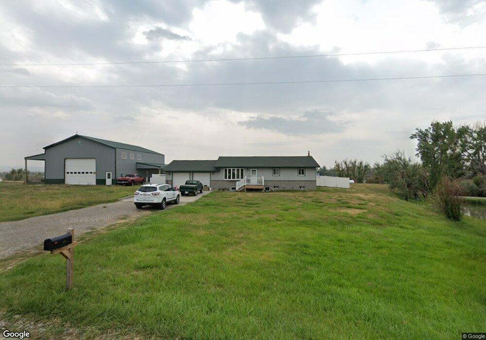
8511 Razor Creek Dr Shepherd, MT 59079
Estimated Value: $477,000 - $536,287
3
Beds
2
Baths
1,232
Sq Ft
$410/Sq Ft
Est. Value
About This Home
This home is located at 8511 Razor Creek Dr, Shepherd, MT 59079 and is currently estimated at $505,572, approximately $410 per square foot. 8511 Razor Creek Dr is a home located in Yellowstone County with nearby schools including Shepherd Elementary School, Shepherd Middle School, and Shepherd High School.
Ownership History
Date
Name
Owned For
Owner Type
Purchase Details
Closed on
Oct 27, 2025
Sold by
Friedrich Daniel E and Friedrich Crystal L
Bought by
Razor Creek Llc
Current Estimated Value
Purchase Details
Closed on
Dec 7, 2016
Sold by
Friedrich Daniel E and Harris Crystal L
Bought by
Friedrich Daniel E and Friedrich Crystal L
Purchase Details
Closed on
Apr 2, 2010
Sold by
Roberson Joshua
Bought by
Harris Crystal L
Purchase Details
Closed on
Mar 23, 2010
Sold by
Harris Crystal L
Bought by
Friedrich Daniel E
Create a Home Valuation Report for This Property
The Home Valuation Report is an in-depth analysis detailing your home's value as well as a comparison with similar homes in the area
Purchase History
| Date | Buyer | Sale Price | Title Company |
|---|---|---|---|
| Razor Creek Llc | -- | None Listed On Document | |
| Friedrich Daniel E | -- | American Title & Escrow | |
| Harris Crystal L | -- | None Available | |
| Friedrich Daniel E | -- | None Available |
Source: Public Records
Tax History
| Year | Tax Paid | Tax Assessment Tax Assessment Total Assessment is a certain percentage of the fair market value that is determined by local assessors to be the total taxable value of land and additions on the property. | Land | Improvement |
|---|---|---|---|---|
| 2025 | $3,599 | $520,000 | $101,829 | $418,171 |
| 2024 | $3,599 | $420,100 | $76,571 | $343,529 |
| 2023 | $3,662 | $420,100 | $76,571 | $343,529 |
| 2022 | $3,151 | $321,800 | $0 | $0 |
| 2021 | $3,143 | $321,800 | $0 | $0 |
| 2020 | $3,055 | $301,900 | $0 | $0 |
| 2019 | $2,531 | $301,900 | $0 | $0 |
| 2018 | $2,279 | $254,400 | $0 | $0 |
| 2017 | $2,237 | $254,400 | $0 | $0 |
| 2016 | $2,047 | $242,400 | $0 | $0 |
| 2015 | $2,029 | $242,400 | $0 | $0 |
| 2014 | $1,661 | $106,053 | $0 | $0 |
Source: Public Records
Map
Nearby Homes
- 6732 Pinto Dr
- 6835 Eagle Bend Blvd
- 7340 Wild Game Trail
- 7420 Whitetail Run
- 5652 Bengston Rd
- 8700 Fox Run
- 8020 Wade St
- 9705 Shepherd Rd
- 5430 Cerkoney Ln
- 0 Shepherd Road Lot Shepherd Rd
- 0 SHepherd Road lot Shepherd Rd
- 3835 Nellie Christine Dr
- 3863 Glenn Edward Rd
- 7684 12 Mile Rd
- 7306 Kendra Lynn Dr
- 7106 Lance St
- 10052 Floating Island Way
- 3625 Nellie Christine Dr
- L5B4 Trumbo Cir
- 7445 Horsemans Way
- 8521 Razor Creek Dr
- 8430 Clark Rd
- 8450 Clark Rd
- 8528 Razor Creek Dr
- 8519 Clark Rd
- 6621 Brave Lookout
- 6609 Brave Lookout
- 8537 Clark Rd
- 8400 Clark Rd
- 6631 Brave Lookout
- 8528 Clark Rd
- 8551 Razor Creek Dr
- 6707 Brave Lookout
- 8556 Razor Creek Dr
- 6708 Bret Ln W
- 6719 Brave Lookout
- 8566 Razor Creek Dr
- 6741 Razor Cir
- 6745 Razor Cir
- 6742 Razor Cir
Your Personal Tour Guide
Ask me questions while you tour the home.