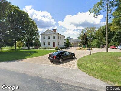
8581 State St Kinsman, OH 44428
Estimated Value: $188,000 - $1,056,997
3
Beds
3
Baths
8,763
Sq Ft
$71/Sq Ft
Est. Value
About This Home
This home is located at 8581 State St, Kinsman, OH 44428 and is currently estimated at $622,499, approximately $71 per square foot. 8581 State St is a home with nearby schools including Badger Elementary School, Badger Middle School, and Badger High School.
Ownership History
Date
Name
Owned For
Owner Type
Purchase Details
Closed on
Apr 2, 2024
Sold by
Thompson Chad R and Thompson Laisa R
Bought by
Richard B And Rhonda M Thompson Foundation
Current Estimated Value
Purchase Details
Closed on
Feb 29, 2024
Sold by
Richard B B and Richard Rhonda M
Bought by
Richard B And Rhonda M Thompson Foundation
Purchase Details
Closed on
Feb 1, 2010
Sold by
Thompson Richard B and Thompson Rhonda M
Bought by
Richard B & Rhonda M Thompson Foundation
Purchase Details
Closed on
Jan 1, 1990
Bought by
Alice C Logan
Create a Home Valuation Report for This Property
The Home Valuation Report is an in-depth analysis detailing your home's value as well as a comparison with similar homes in the area
Home Values in the Area
Average Home Value in this Area
Purchase History
| Date | Buyer | Sale Price | Title Company |
|---|---|---|---|
| Richard B And Rhonda M Thompson Foundation | -- | None Listed On Document | |
| Richard B And Rhonda M Thompson Foundation | -- | None Listed On Document | |
| Richard B & Rhonda M Thompson Foundation | -- | Attorney | |
| Alice C Logan | -- | -- |
Source: Public Records
Tax History Compared to Growth
Tax History
| Year | Tax Paid | Tax Assessment Tax Assessment Total Assessment is a certain percentage of the fair market value that is determined by local assessors to be the total taxable value of land and additions on the property. | Land | Improvement |
|---|---|---|---|---|
| 2023 | $22,571 | $396,350 | $22,020 | $374,330 |
| 2022 | $20,985 | $328,730 | $19,010 | $309,720 |
| 2021 | $11,738 | $183,720 | $19,010 | $164,710 |
| 2020 | $11,788 | $183,720 | $19,010 | $164,710 |
| 2019 | $11,844 | $183,720 | $19,010 | $164,710 |
| 2018 | $9,117 | $141,860 | $19,010 | $122,850 |
| 2017 | $9,077 | $141,860 | $19,010 | $122,850 |
| 2016 | $8,924 | $139,170 | $17,120 | $122,050 |
| 2015 | $4,928 | $77,290 | $17,120 | $60,170 |
| 2014 | $1,657 | $31,260 | $8,610 | $22,650 |
| 2013 | $1,749 | $31,260 | $8,610 | $22,650 |
Source: Public Records
Map
Nearby Homes
- 5845 Burton Bloomfield
- 8638 Youngstown Conneaut Rd
- 5921 Mayburn Barclay Rd
- 9758 Kinsman Pymatuning Rd
- 6563 County Line Rd
- 6027 & 6515 Oh-88
- 8517 State Route 7
- 0 Bushnell Campbell Rd
- 6416 State Route 88
- 549 Kinsman Rd
- 9960 Ridge Rd
- 8074 State Route 7
- 4449 Greenville (St Rt 88) Rd
- 6068 Beach Smith Rd
- 7724 Stanhope-Kelloggsville Rd
- 6003 Youngstown Kingsville Rd
- 53 Acres Bates and Fry Roads
- 5372 Slater Rd
- 8122 Oak St
- 6092 Warren Rd
- 8581 State St
- 8578 State St
- 8590 State St
- 8560 State St
- 8620 State St
- 8525 State St
- 8622 State St
- 6159 State Route 87
- 8661 State St
- 8488 State St
- 0 Sr 87 Unit 2447128
- 0 Sr 87 Unit 2484395
- 8468 State St
- 8465 State St
- 8453 State St
- 8698 State St
- 8447 State St
- 8446 State St
- 6417 Burton
- 6410 Burton Bloomfield