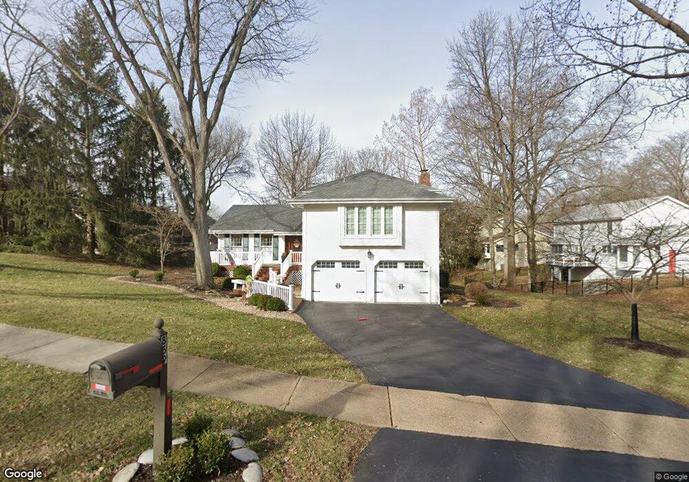
859 White Rock Dr Saint Louis, MO 63131
Estimated Value: $604,752 - $681,000
4
Beds
3
Baths
2,525
Sq Ft
$256/Sq Ft
Est. Value
About This Home
This home is located at 859 White Rock Dr, Saint Louis, MO 63131 and is currently estimated at $647,438, approximately $256 per square foot. 859 White Rock Dr is a home located in St. Louis County with nearby schools including Barretts Elementary School, Parkway South Middle School, and Parkway South High School.
Ownership History
Date
Name
Owned For
Owner Type
Purchase Details
Closed on
Feb 23, 2016
Sold by
Meehan Harry D and Metcalf Meehan Joyce
Bought by
The Meehan Living Trusty and Meehan Joyce M
Current Estimated Value
Purchase Details
Closed on
May 15, 1998
Sold by
Stephen Hamby Harold
Bought by
Meehan Harry D and Metcalf Meehan Joyce
Home Financials for this Owner
Home Financials are based on the most recent Mortgage that was taken out on this home.
Original Mortgage
$225,000
Outstanding Balance
$44,002
Interest Rate
7.11%
Estimated Equity
$603,436
Create a Home Valuation Report for This Property
The Home Valuation Report is an in-depth analysis detailing your home's value as well as a comparison with similar homes in the area
Home Values in the Area
Average Home Value in this Area
Purchase History
| Date | Buyer | Sale Price | Title Company |
|---|---|---|---|
| The Meehan Living Trusty | -- | None Available | |
| Meehan Harry D | -- | -- |
Source: Public Records
Mortgage History
| Date | Status | Borrower | Loan Amount |
|---|---|---|---|
| Open | Meehan Harry D | $225,000 |
Source: Public Records
Tax History Compared to Growth
Tax History
| Year | Tax Paid | Tax Assessment Tax Assessment Total Assessment is a certain percentage of the fair market value that is determined by local assessors to be the total taxable value of land and additions on the property. | Land | Improvement |
|---|---|---|---|---|
| 2025 | $5,056 | $107,330 | $52,120 | $55,210 |
| 2024 | $5,056 | $89,980 | $36,080 | $53,900 |
| 2023 | $4,982 | $89,980 | $36,080 | $53,900 |
| 2022 | $4,914 | $80,640 | $34,490 | $46,150 |
| 2021 | $4,873 | $80,640 | $34,490 | $46,150 |
| 2020 | $4,311 | $68,160 | $27,210 | $40,950 |
| 2019 | $4,251 | $68,160 | $27,210 | $40,950 |
| 2018 | $4,212 | $62,440 | $23,390 | $39,050 |
| 2017 | $4,156 | $62,440 | $23,390 | $39,050 |
| 2016 | $3,703 | $52,850 | $14,740 | $38,110 |
| 2015 | $3,902 | $52,850 | $14,740 | $38,110 |
| 2014 | $4,028 | $59,280 | $19,910 | $39,370 |
Source: Public Records
Map
Nearby Homes
- 12213 Brook Springs Ct
- 2300 E Royal Ct
- 2211 Viewroyal Dr
- 2145 Trailcrest Dr
- 2037 Trailcrest Ln Unit 7
- 2405 Fairoyal Dr
- 698 Trailcrest Ct Unit 5
- 12841 Thornhill Ct
- 918 N Ballas Rd
- 591-593 N Ballas Rd
- 12224 TBB Roger Ln
- 2000 Trailcrest Ln Unit 3
- 2033 Woodland Knoll
- 2025 Woodland Knoll
- 2005 Woodland Knoll
- 12819 Huntercreek Rd
- 2002 Woodland Knoll
- 1824 Topping Rd
- 13124 Huntercreek Ridge Rd
- 467 Tree Top Ln
- 12860 White Rock Ct
- 12859 4 Winds Farm Dr
- 12866 White Rock Ct
- 12865 Four Winds Farm
- 12865 4 Winds Farm Dr
- 858 White Rock Dr
- 852 White Rock Dr
- 12847 4 Winds Farm Dr
- 12872 White Rock Ct
- 864 White Rock Dr
- 12871 4 Winds Farm Dr
- 12861 White Rock Ct
- 12858 4 Winds Farm Dr
- 12855 White Rock Ct
- 12867 White Rock Ct
- 12841 4 Winds Farm Dr
- 870 White Rock Dr
- 12878 White Rock Ct
- 12846 4 Winds Farm Dr
- 12870 4 Winds Farm Dr