
Seller's Agent in 2026
Jennifer Anderson
RE/MAX
16 in this area
49 Total Sales


Estimated Value: $543,000 - $567,000
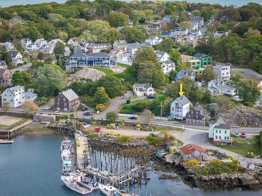
Opportunity knocks in East Gloucester! This 3-family property offers endless potential for investors, contractors, or creative homeowners. Enjoy water views of beautiful Cripple Cove and imagine watching the sun rise and set while sipping your morning coffee. Each unit offers unique character and layout—ready to be reimagined or restored to your taste. With a little vision and creativity, the possibilities are endless. Offered as-is in a peaceful coastal enclave loved for its views, charm, and walkable lifestyle. No off-street parking.
| Date | Buyer | Sale Price | Title Company |
|---|---|---|---|
| Pierre Widy | $550,000 | -- | |
| Warren Maudeann | $82,000 | -- | |
| Calaska Partners A Ltd | $150,551 | -- |
| Date | Status | Borrower | Loan Amount |
|---|---|---|---|
| Open | Pierre Widy | $872,500 | |
| Previous Owner | Calaska Partners A Ltd | $9,924 | |
| Previous Owner | Calaska Partners A Ltd | $29,963 | |
| Previous Owner | Calaska Partners A Ltd | $67,000 |
| Date | Event | Price | List to Sale | Price per Sq Ft |
|---|---|---|---|---|
| 01/06/2026 01/06/26 | Sold | $550,000 | +0.2% | $276 / Sq Ft |
| 11/21/2025 11/21/25 | Pending | -- | -- | -- |
| 10/30/2025 10/30/25 | For Sale | $549,000 | -- | $276 / Sq Ft |
| Year | Tax Paid | Tax Assessment Tax Assessment Total Assessment is a certain percentage of the fair market value that is determined by local assessors to be the total taxable value of land and additions on the property. | Land | Improvement |
|---|---|---|---|---|
| 2025 | $5,689 | $585,300 | $152,000 | $433,300 |
| 2024 | $5,309 | $545,600 | $144,700 | $400,900 |
| 2023 | $5,499 | $519,300 | $129,200 | $390,100 |
| 2022 | $4,986 | $425,100 | $112,400 | $312,700 |
| 2021 | $4,827 | $388,000 | $102,200 | $285,800 |
| 2020 | $4,584 | $371,800 | $102,200 | $269,600 |
| 2019 | $4,284 | $337,600 | $102,200 | $235,400 |
| 2018 | $4,132 | $319,600 | $102,200 | $217,400 |
| 2017 | $3,985 | $302,100 | $97,300 | $204,800 |
| 2016 | $3,777 | $277,500 | $101,500 | $176,000 |
| 2015 | $3,714 | $272,100 | $101,500 | $170,600 |
Seller's Agent in 2026
Jennifer Anderson
RE/MAX
16 in this area
49 Total Sales
Buyer's Agent in 2026
Michele Allison-Elwell
Coldwell Banker Realty - Beverly
(978) 766-8041
1 in this area
13 Total Sales
Source: MLS Property Information Network (MLS PIN)
MLS Number: 73449533
APN: GLOU-000058-000031
Disclaimer: Certain information contained herein is derived from information provided by parties other than Homes.com. All information provided is deemed reliable, but is not guaranteed to be accurate and should be independently verified.
![]() The property listing data and information, or the Images, set forth herein were provided to MLS Property Information Network, Inc. from third party sources, including sellers, lessors and public records, and were compiled by MLS Property Information Network, Inc. The property listing data and information, and the Images, are for the personal, non-commercial use of consumers having a good faith interest in purchasing or leasing listed properties of the type displayed to them and may not be used for any purpose other than to identify prospective properties which such consumers may have a good faith interest in purchasing or leasing. MLS Property Information Network, Inc. and its subscribers disclaim any and all representations and warranties as to the accuracy of the property listing data and information, or as to the accuracy of any of the Images, set forth herein.
The property listing data and information, or the Images, set forth herein were provided to MLS Property Information Network, Inc. from third party sources, including sellers, lessors and public records, and were compiled by MLS Property Information Network, Inc. The property listing data and information, and the Images, are for the personal, non-commercial use of consumers having a good faith interest in purchasing or leasing listed properties of the type displayed to them and may not be used for any purpose other than to identify prospective properties which such consumers may have a good faith interest in purchasing or leasing. MLS Property Information Network, Inc. and its subscribers disclaim any and all representations and warranties as to the accuracy of the property listing data and information, or as to the accuracy of any of the Images, set forth herein.
Ask me questions while you tour the home.