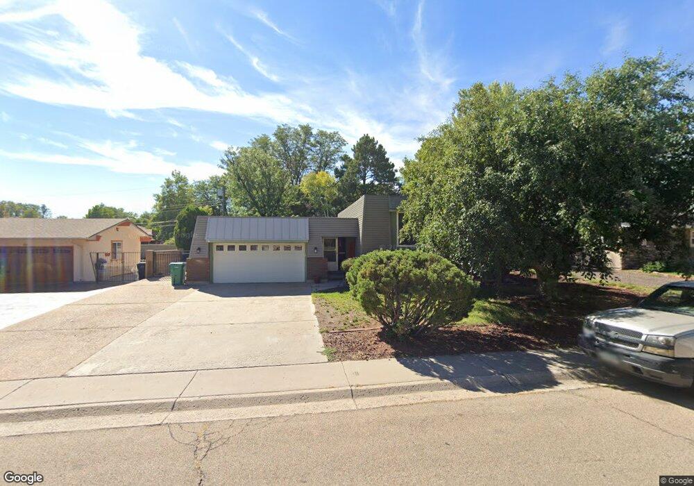
86 Fordham Cir Pueblo, CO 81005
Sunset NeighborhoodEstimated Value: $270,000 - $355,000
2
Beds
2
Baths
1,052
Sq Ft
$284/Sq Ft
Est. Value
About This Home
This home is located at 86 Fordham Cir, Pueblo, CO 81005 and is currently estimated at $298,744, approximately $283 per square foot. 86 Fordham Cir is a home located in Pueblo County with nearby schools including Sunset Park Elementary School, Pueblo Academy of Arts, and South High School.
Ownership History
Date
Name
Owned For
Owner Type
Purchase Details
Closed on
Apr 10, 2023
Sold by
White Phillip A
Bought by
White Phillip A and White Erin Fay
Current Estimated Value
Home Financials for this Owner
Home Financials are based on the most recent Mortgage that was taken out on this home.
Original Mortgage
$319,651
Outstanding Balance
$310,848
Interest Rate
6.65%
Mortgage Type
VA
Estimated Equity
-$12,104
Purchase Details
Closed on
Jun 23, 2021
Sold by
Cummins Tom E
Bought by
Wissel Diane Fay
Home Financials for this Owner
Home Financials are based on the most recent Mortgage that was taken out on this home.
Original Mortgage
$219,024
Interest Rate
2.9%
Mortgage Type
VA
Purchase Details
Closed on
Jun 22, 2021
Sold by
Wissel Diane Fay and Estate Of Tom E Cummins
Bought by
White Phillip A
Home Financials for this Owner
Home Financials are based on the most recent Mortgage that was taken out on this home.
Original Mortgage
$219,024
Interest Rate
2.9%
Mortgage Type
VA
Purchase Details
Closed on
Apr 23, 1984
Sold by
James Frederick T Jr + Maria
Bought by
Cummins Tom E + Beatrice R
Purchase Details
Closed on
Nov 13, 1973
Sold by
Horton James O + Elizabeth A
Bought by
James Frederick T Jr + Maria
Create a Home Valuation Report for This Property
The Home Valuation Report is an in-depth analysis detailing your home's value as well as a comparison with similar homes in the area
Home Values in the Area
Average Home Value in this Area
Purchase History
| Date | Buyer | Sale Price | Title Company |
|---|---|---|---|
| White Phillip A | -- | None Listed On Document | |
| White Phillip A | -- | None Listed On Document | |
| Wissel Diane Fay | -- | -- | |
| White Phillip A | $240,000 | None Available | |
| Cummins Tom E + Beatrice R | $68,500 | -- | |
| James Frederick T Jr + Maria | $44,500 | -- |
Source: Public Records
Mortgage History
| Date | Status | Borrower | Loan Amount |
|---|---|---|---|
| Open | White Phillip A | $319,651 | |
| Closed | White Phillip A | $319,651 | |
| Previous Owner | White Phillip A | $219,024 |
Source: Public Records
Tax History Compared to Growth
Tax History
| Year | Tax Paid | Tax Assessment Tax Assessment Total Assessment is a certain percentage of the fair market value that is determined by local assessors to be the total taxable value of land and additions on the property. | Land | Improvement |
|---|---|---|---|---|
| 2024 | $1,656 | $16,900 | -- | -- |
| 2023 | $1,674 | $20,590 | $2,010 | $18,580 |
| 2022 | $1,419 | $14,295 | $2,090 | $12,205 |
| 2021 | $1,465 | $14,710 | $2,150 | $12,560 |
| 2020 | $669 | $16,210 | $2,150 | $14,060 |
| 2019 | $670 | $13,023 | $1,144 | $11,879 |
| 2018 | $510 | $11,036 | $1,152 | $9,884 |
| 2017 | $515 | $11,036 | $1,152 | $9,884 |
| 2016 | $498 | $10,813 | $1,274 | $9,539 |
| 2015 | $248 | $10,813 | $1,274 | $9,539 |
| 2014 | $491 | $10,676 | $1,274 | $9,402 |
Source: Public Records
Map
Nearby Homes