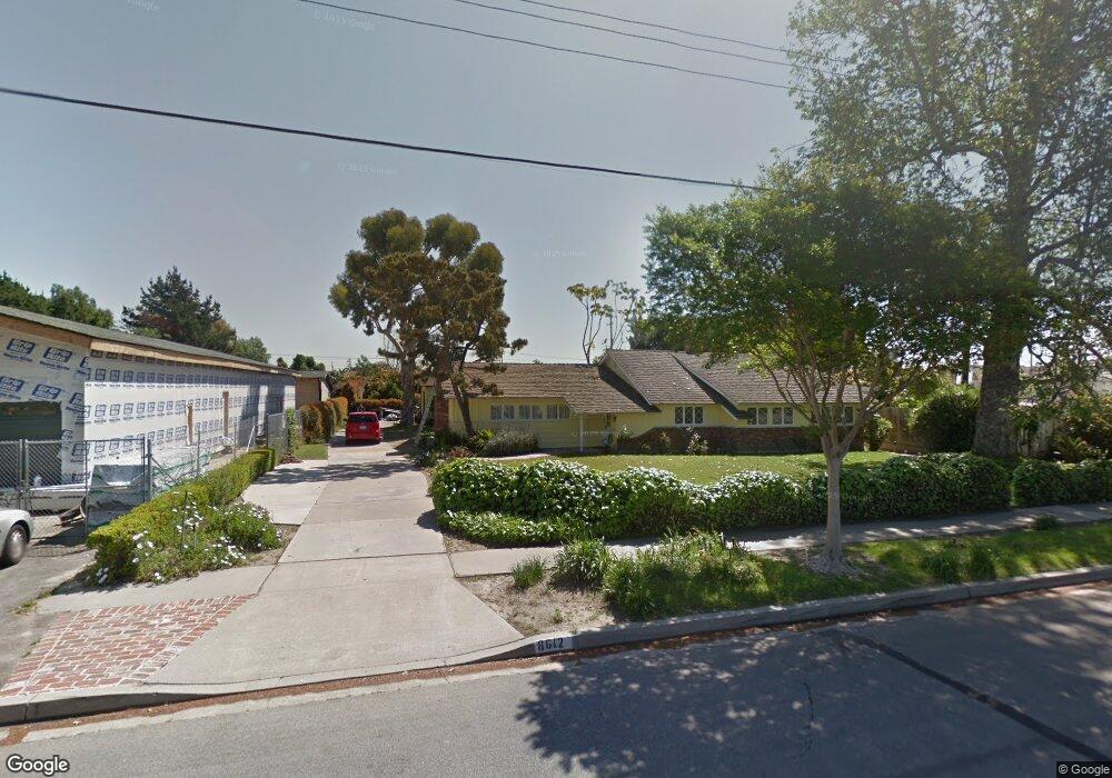
8612 Kendor Dr Buena Park, CA 90620
Estimated Value: $913,000 - $996,756
3
Beds
2
Baths
1,708
Sq Ft
$554/Sq Ft
Est. Value
About This Home
This home is located at 8612 Kendor Dr, Buena Park, CA 90620 and is currently estimated at $946,939, approximately $554 per square foot. 8612 Kendor Dr is a home located in Orange County with nearby schools including Glen H. Dysinger Sr. Elementary School, Dale Jr High School, and Savanna High School.
Ownership History
Date
Name
Owned For
Owner Type
Purchase Details
Closed on
Jun 10, 2024
Sold by
Whitney Thomas
Bought by
Thomas And Melissa Whitney Living Trust and Whitney
Current Estimated Value
Purchase Details
Closed on
May 17, 2024
Sold by
Whitney Property Trust and Neil Laurie L
Bought by
Whitney Thomas
Purchase Details
Closed on
Feb 8, 2021
Sold by
Whitney Edward James and Whitney Neil Laurie
Bought by
Neil Laurie L and Whitney Property Trust
Purchase Details
Closed on
Jun 19, 2019
Sold by
Whitney Edward James
Bought by
Lynn Whitney Edward James and Lynn Neil Laurie
Create a Home Valuation Report for This Property
The Home Valuation Report is an in-depth analysis detailing your home's value as well as a comparison with similar homes in the area
Home Values in the Area
Average Home Value in this Area
Purchase History
| Date | Buyer | Sale Price | Title Company |
|---|---|---|---|
| Thomas And Melissa Whitney Living Trust | -- | None Listed On Document | |
| Whitney Thomas | -- | None Listed On Document | |
| Neil Laurie L | -- | None Available | |
| Lynn Whitney Edward James | -- | None Available |
Source: Public Records
Tax History Compared to Growth
Tax History
| Year | Tax Paid | Tax Assessment Tax Assessment Total Assessment is a certain percentage of the fair market value that is determined by local assessors to be the total taxable value of land and additions on the property. | Land | Improvement |
|---|---|---|---|---|
| 2025 | $1,379 | $91,011 | $40,039 | $50,972 |
| 2024 | $1,379 | $89,227 | $39,254 | $49,973 |
| 2023 | $1,343 | $87,478 | $38,484 | $48,994 |
| 2022 | $1,321 | $85,763 | $37,729 | $48,034 |
| 2021 | $1,224 | $84,082 | $36,989 | $47,093 |
| 2020 | $1,215 | $83,220 | $36,609 | $46,611 |
| 2019 | $1,190 | $81,589 | $35,891 | $45,698 |
| 2018 | $1,169 | $79,990 | $35,188 | $44,802 |
| 2017 | $1,136 | $78,422 | $34,498 | $43,924 |
| 2016 | $1,116 | $76,885 | $33,822 | $43,063 |
| 2015 | $1,101 | $75,731 | $33,314 | $42,417 |
| 2014 | $1,052 | $74,248 | $32,661 | $41,587 |
Source: Public Records
Map
Nearby Homes
- 400 N Syracuse St
- 2955 W Lincoln Ave Unit 7
- 2871 W Tyler Ave
- 8319 Hickory Dr
- 605 N La Reina St
- 2943 W Lincoln Ave
- 8452 Stanton Ave
- 2770 W Lincoln Ave Unit 40
- 2770 W Lincoln Ave Unit 58
- 2709 W Madison Cir
- Plan Two at Mason
- Plan Four at Mason
- Plan Three at Mason
- Plan Seven at Mason
- 199 N Magnolia Ave Unit B
- 109 S Laxore St
- 103 S Laxore St
- 106 S Laxore St Unit 407
- 107 S Laxore St
- 8054 Teakwood Cir
- 8602 Kendor Dr
- 8646 Kendor Cir
- 8640 Kendor Dr
- 8650 Kendor Cir
- 8582 Kendor Dr
- 8613 Kendor Dr
- 8625 Kendor Dr
- 517 N Dale Ave
- 511 N Dale Ave
- 8601 Kendor Dr
- 8637 Kendor Dr
- 519 N Dale Ave
- 8649 Kendor Dr
- 8562 Kendor Dr
- 523 N Dale Ave
- 8656 Kendor Cir
- 8612 Cherry Cir
- 8661 Kendor Dr
- 8622 Cherry Cir
- 8571 Kendor Dr