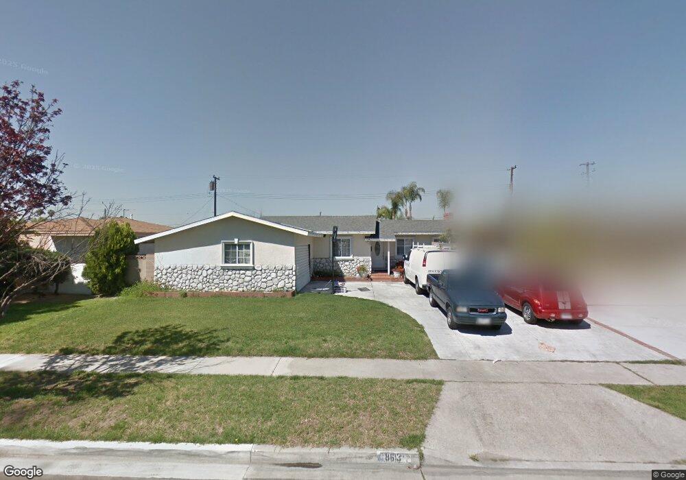
8613 Kendor Dr Buena Park, CA 90620
Estimated Value: $905,000 - $1,060,000
4
Beds
3
Baths
1,717
Sq Ft
$556/Sq Ft
Est. Value
About This Home
This home is located at 8613 Kendor Dr, Buena Park, CA 90620 and is currently estimated at $954,495, approximately $555 per square foot. 8613 Kendor Dr is a home located in Orange County with nearby schools including Glen H. Dysinger Sr. Elementary School, Dale Jr High School, and Savanna High School.
Ownership History
Date
Name
Owned For
Owner Type
Purchase Details
Closed on
Mar 16, 1995
Sold by
Yancey Anita J and Yancey Faure Laurel
Bought by
Lopez Francisco I and Suazo Lopez Guillermina
Current Estimated Value
Home Financials for this Owner
Home Financials are based on the most recent Mortgage that was taken out on this home.
Original Mortgage
$151,525
Interest Rate
8.46%
Create a Home Valuation Report for This Property
The Home Valuation Report is an in-depth analysis detailing your home's value as well as a comparison with similar homes in the area
Home Values in the Area
Average Home Value in this Area
Purchase History
| Date | Buyer | Sale Price | Title Company |
|---|---|---|---|
| Lopez Francisco I | -- | Landwood Title Company |
Source: Public Records
Mortgage History
| Date | Status | Borrower | Loan Amount |
|---|---|---|---|
| Previous Owner | Lopez Francisco I | $151,525 |
Source: Public Records
Tax History Compared to Growth
Tax History
| Year | Tax Paid | Tax Assessment Tax Assessment Total Assessment is a certain percentage of the fair market value that is determined by local assessors to be the total taxable value of land and additions on the property. | Land | Improvement |
|---|---|---|---|---|
| 2025 | $3,451 | $281,934 | $171,453 | $110,481 |
| 2024 | $3,451 | $276,406 | $168,091 | $108,315 |
| 2023 | $3,365 | $270,987 | $164,795 | $106,192 |
| 2022 | $3,320 | $265,674 | $161,564 | $104,110 |
| 2021 | $3,274 | $260,465 | $158,396 | $102,069 |
| 2020 | $3,254 | $257,795 | $156,772 | $101,023 |
| 2019 | $3,177 | $252,741 | $153,698 | $99,043 |
| 2018 | $3,121 | $247,786 | $150,685 | $97,101 |
| 2017 | $3,025 | $242,928 | $147,730 | $95,198 |
| 2016 | $2,969 | $238,165 | $144,833 | $93,332 |
| 2015 | $2,936 | $234,588 | $142,657 | $91,931 |
| 2014 | $2,793 | $229,993 | $139,862 | $90,131 |
Source: Public Records
Map
Nearby Homes
- 2955 W Lincoln Ave Unit 7
- 2871 W Tyler Ave
- 8319 Hickory Dr
- 400 N Syracuse St
- 8452 Stanton Ave
- 605 N La Reina St
- 2943 W Lincoln Ave
- 2770 W Lincoln Ave Unit 40
- 2770 W Lincoln Ave Unit 58
- Plan Two at Mason
- Plan Four at Mason
- Plan Three at Mason
- Plan Seven at Mason
- 109 S Laxore St
- 7950 Jackson Way
- 3053 W Coolidge Ave
- 103 S Laxore St
- 106 S Laxore St Unit 407
- 107 S Laxore St
- 2709 W Madison Cir
- 8601 Kendor Dr
- 8625 Kendor Dr
- 8612 Cherry Cir
- 8637 Kendor Dr
- 8622 Cherry Cir
- 8602 Cherry Cir
- 8571 Kendor Dr
- 8649 Kendor Dr
- 8632 Cherry Cir
- 8640 Kendor Dr
- 8612 Kendor Dr
- 8598 Cedar Dr
- 8602 Kendor Dr
- 8586 Cedar Dr
- 8561 Kendor Dr
- 8661 Kendor Dr
- 8646 Kendor Cir
- 8638 Cedar Dr
- 8582 Kendor Dr
- 8664 Chestnut Cir