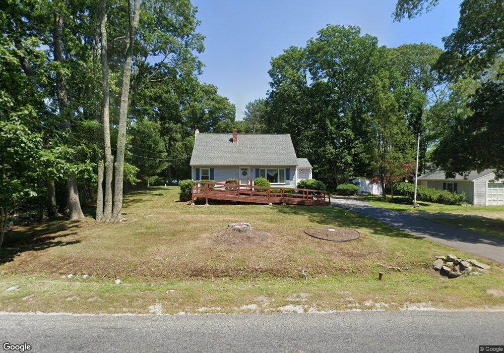
863 Sharps Lot Rd Swansea, MA 02777
Northeast Swansea NeighborhoodEstimated Value: $410,000 - $478,000
3
Beds
1
Bath
998
Sq Ft
$453/Sq Ft
Est. Value
About This Home
This home is located at 863 Sharps Lot Rd, Swansea, MA 02777 and is currently estimated at $452,504, approximately $453 per square foot. 863 Sharps Lot Rd is a home located in Bristol County with nearby schools including Joseph Case High School, SCEC Life Academy, and Swansea Wood School.
Ownership History
Date
Name
Owned For
Owner Type
Purchase Details
Closed on
Feb 28, 2012
Sold by
Hickey Janice J
Bought by
Carvalho Paula A and Hickey Jeffrey P
Current Estimated Value
Purchase Details
Closed on
May 20, 2009
Sold by
Hickey Paul H and Hickey Janice J
Bought by
Hickey Janice J
Create a Home Valuation Report for This Property
The Home Valuation Report is an in-depth analysis detailing your home's value as well as a comparison with similar homes in the area
Home Values in the Area
Average Home Value in this Area
Purchase History
| Date | Buyer | Sale Price | Title Company |
|---|---|---|---|
| Carvalho Paula A | -- | -- | |
| Hickey Janice J | -- | -- |
Source: Public Records
Mortgage History
| Date | Status | Borrower | Loan Amount |
|---|---|---|---|
| Previous Owner | Carvalho Paula A | $45,000 | |
| Previous Owner | Carvalho Paula A | $35,500 | |
| Previous Owner | Carvalho Paula A | $50,000 |
Source: Public Records
Tax History Compared to Growth
Tax History
| Year | Tax Paid | Tax Assessment Tax Assessment Total Assessment is a certain percentage of the fair market value that is determined by local assessors to be the total taxable value of land and additions on the property. | Land | Improvement |
|---|---|---|---|---|
| 2025 | $4,494 | $377,000 | $155,000 | $222,000 |
| 2024 | $4,472 | $373,000 | $155,000 | $218,000 |
| 2023 | $4,104 | $312,600 | $113,500 | $199,100 |
| 2022 | $4,091 | $284,300 | $103,200 | $181,100 |
| 2021 | $3,904 | $249,800 | $103,200 | $146,600 |
| 2020 | $3,870 | $248,400 | $103,200 | $145,200 |
| 2019 | $3,629 | $234,000 | $91,800 | $142,200 |
| 2018 | $3,551 | $232,400 | $90,200 | $142,200 |
| 2017 | $3,166 | $238,400 | $90,200 | $148,200 |
| 2016 | $2,972 | $219,800 | $78,000 | $141,800 |
| 2015 | $2,770 | $211,000 | $78,000 | $133,000 |
| 2014 | $2,669 | $207,900 | $78,000 | $129,900 |
Source: Public Records
Map
Nearby Homes
- 476 Marvel St
- 858 Sharps Lot Rd
- 454 Marvel St
- 819 Sharps Lot Rd
- 830 Sharps Lot Rd
- 520 Marvel St
- 822 Sharps Lot Rd
- 495 Marvel St
- 438 Marvel St
- 0CWest Sharps Lot Rd
- 814 Sharps Lot Rd
- 821 Sharps Lot Rd
- 827 Sharps Lot Rd
- 542 Marvel St
- 890 Sharps Lot Rd
- 422 Marvel St
- 465 Marvel St
- 55 Sailmaker Ct
- 545 Marvel St
- 560 Marvel St