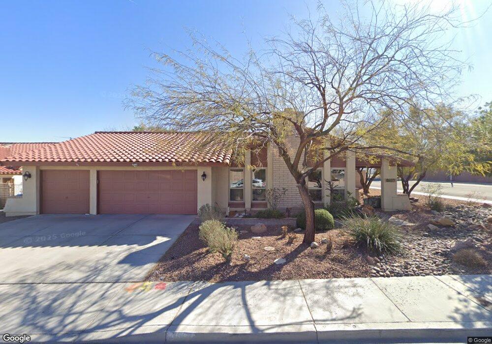
8657 Orvieto Dr Las Vegas, NV 89117
Canyon Gate NeighborhoodEstimated Value: $568,715 - $602,000
4
Beds
2
Baths
1,869
Sq Ft
$310/Sq Ft
Est. Value
About This Home
This home is located at 8657 Orvieto Dr, Las Vegas, NV 89117 and is currently estimated at $579,929, approximately $310 per square foot. 8657 Orvieto Dr is a home located in Clark County with nearby schools including Clarence A. Piggott Academy of International Studies, D'Vorre & Hal Ober Elementary School, and Walter Johnson Junior High School Academy of International Studies.
Ownership History
Date
Name
Owned For
Owner Type
Purchase Details
Closed on
May 13, 1994
Sold by
Fiore John R and Fiore Patrice L
Bought by
Mitchell Debra A and Tate Jessica R
Current Estimated Value
Home Financials for this Owner
Home Financials are based on the most recent Mortgage that was taken out on this home.
Original Mortgage
$141,300
Interest Rate
8.3%
Create a Home Valuation Report for This Property
The Home Valuation Report is an in-depth analysis detailing your home's value as well as a comparison with similar homes in the area
Home Values in the Area
Average Home Value in this Area
Purchase History
| Date | Buyer | Sale Price | Title Company |
|---|---|---|---|
| Mitchell Debra A | $157,000 | Nevada Title Company |
Source: Public Records
Mortgage History
| Date | Status | Borrower | Loan Amount |
|---|---|---|---|
| Closed | Mitchell Debra A | $141,300 |
Source: Public Records
Tax History Compared to Growth
Tax History
| Year | Tax Paid | Tax Assessment Tax Assessment Total Assessment is a certain percentage of the fair market value that is determined by local assessors to be the total taxable value of land and additions on the property. | Land | Improvement |
|---|---|---|---|---|
| 2025 | $2,684 | $110,111 | $45,850 | $64,261 |
| 2024 | $2,607 | $110,111 | $45,850 | $64,261 |
| 2023 | $2,607 | $104,817 | $43,050 | $61,767 |
| 2022 | $2,531 | $93,045 | $35,700 | $57,345 |
| 2021 | $2,457 | $86,844 | $31,850 | $54,994 |
| 2020 | $2,383 | $83,682 | $28,700 | $54,982 |
| 2019 | $2,313 | $81,885 | $27,300 | $54,585 |
| 2018 | $2,246 | $78,003 | $24,850 | $53,153 |
| 2017 | $2,576 | $78,572 | $24,150 | $54,422 |
| 2016 | $2,127 | $74,158 | $19,250 | $54,908 |
| 2015 | $2,122 | $64,680 | $15,050 | $49,630 |
| 2014 | $2,060 | $60,984 | $11,200 | $49,784 |
Source: Public Records
Map
Nearby Homes
- 1536 Brocado Ln
- 8813 Pavia Dr
- 1517 Kirby Dr
- 8756 Potenza Ln
- 8721 Robinson Ridge Dr
- 8505 Custer Ct
- 8808 Silvagni Dr
- 1613 Iron Ridge Dr
- 8600 W Charleston Blvd Unit 1079
- 8600 W Charleston Blvd Unit 2058
- 8600 W Charleston Blvd Unit 1030
- 8600 W Charleston Blvd Unit 1075
- 8600 W Charleston Blvd Unit 2195
- 8600 W Charleston Blvd Unit 2101
- 8821 Robinson Ridge Dr
- 8908 Silvagni Dr
- 1209 Emerywood Ct
- 8901 Robinson Ridge Dr
- 1805 Quail Point Ct
- 805 Overview Dr
- 8653 Orvieto Dr
- 8656 Isola Dr
- 8652 Isola Dr
- 8701 Orvieto Dr
- 8649 Orvieto Dr Unit 2
- 8656 Orvieto Dr
- 8652 Orvieto Dr
- 8648 Isola Dr
- 8648 Orvieto Dr
- 8700 Orvieto Dr
- 8645 Orvieto Dr
- 8645 Orvieto Dr Unit n/a
- 8704 Isola Dr
- 1501 Merialdo Ln
- 8653 Relente Ct
- 8644 Orvieto Dr
- 8704 Orvieto Dr
- 8644 Isola Dr
- 1500 Frandosa Ln Unit 3
- 8701 Isola Dr Unit 2