
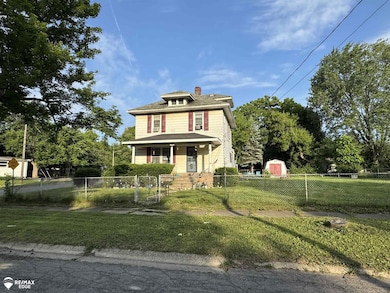
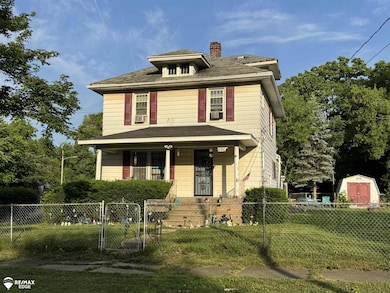
866 Tacken St Flint, MI 48532
West Court Gardens NeighborhoodEstimated payment $450/month
Highlights
- Colonial Architecture
- 2 Car Detached Garage
- Forced Air Heating System
- Corner Lot
About This Home
Check out this great home.
Home Details
Home Type
- Single Family
Est. Annual Taxes
Year Built
- Built in 1927
Lot Details
- 4,356 Sq Ft Lot
- 46 Ft Wide Lot
- Corner Lot
Parking
- 2 Car Detached Garage
Home Design
- Colonial Architecture
Interior Spaces
- 1,664 Sq Ft Home
- 2-Story Property
- Unfinished Basement
Bedrooms and Bathrooms
- 4 Bedrooms
- 3 Full Bathrooms
Utilities
- Forced Air Heating System
- Heating System Uses Natural Gas
Community Details
- West Court Gardens Subdivision
Listing and Financial Details
- Assessor Parcel Number 40-15-431-011
Map
Home Values in the Area
Average Home Value in this Area
Tax History
| Year | Tax Paid | Tax Assessment Tax Assessment Total Assessment is a certain percentage of the fair market value that is determined by local assessors to be the total taxable value of land and additions on the property. | Land | Improvement |
|---|---|---|---|---|
| 2025 | $1,377 | $30,700 | $0 | $0 |
| 2024 | $1,270 | $31,000 | $0 | $0 |
| 2023 | $1,237 | $27,400 | $0 | $0 |
| 2022 | $0 | $22,300 | $0 | $0 |
| 2021 | $1,256 | $18,900 | $0 | $0 |
| 2020 | $1,150 | $17,100 | $0 | $0 |
| 2019 | $1,120 | $15,500 | $0 | $0 |
| 2018 | $1,122 | $13,200 | $0 | $0 |
| 2017 | $1,092 | $0 | $0 | $0 |
| 2016 | $1,084 | $0 | $0 | $0 |
| 2015 | -- | $0 | $0 | $0 |
| 2014 | -- | $0 | $0 | $0 |
| 2012 | -- | $16,900 | $0 | $0 |
Property History
| Date | Event | Price | List to Sale | Price per Sq Ft |
|---|---|---|---|---|
| 11/17/2025 11/17/25 | Pending | -- | -- | -- |
| 10/21/2025 10/21/25 | Price Changed | $63,690 | -7.6% | $38 / Sq Ft |
| 09/05/2025 09/05/25 | Price Changed | $68,900 | -22.5% | $41 / Sq Ft |
| 07/18/2025 07/18/25 | For Sale | $88,900 | -- | $53 / Sq Ft |
Purchase History
| Date | Type | Sale Price | Title Company |
|---|---|---|---|
| Interfamily Deed Transfer | -- | Title Michigan Agency Ltd | |
| Warranty Deed | $87,000 | -- |
Mortgage History
| Date | Status | Loan Amount | Loan Type |
|---|---|---|---|
| Open | $94,000 | New Conventional |
Source: Michigan Multiple Listing Service
MLS Number: 50182226
APN: 40-15-431-011
Disclaimer: Certain information contained herein is derived from information provided by parties other than Homes.com. All information provided is deemed reliable, but is not guaranteed to be accurate and should be independently verified.
![]() Source MLS: MiRealSource
Source MLS: MiRealSource
Provided through IDX via MiRealSource. Courtesy of MiRealSource Shareholder. Copyright MiRealSource.
The information published and disseminated by MiRealSource is communicated verbatim, without change by MiRealSource, as filed with MiRealSource by its members. The accuracy of all information, regardless of source, is not guaranteed or warranted. All information should be independently verified.
Copyright 2025 MiRealSource. All rights reserved. The information provided hereby constitutes proprietary information of MiRealSource, Inc. and its shareholders, affiliates and licensees and may not be reproduced or transmitted in any form or by any means, electronic or mechanical, including photocopy, recording, scanning or any information storage and retrieval system, without written permission from MiRealSource, Inc.
- 870 Tacken St
- 874 Tacken St
- 863 Tacken St
- 3921 Joyner St
- 3821 W Court St
- 959 Tacken St
- 960 Salisbury Ave
- 3705 Gratiot Ave
- 3477 Ridgecliffe Dr
- 3414 Van Buren Ave
- 916 Mann Ave
- 3631 Ridgecliffe Dr
- 976 Barney Ave
- 996 Barney Ave
- 960 Mann Ave
- 3517 Norwood Dr
- 3320 Timberview St
- 3801 Augusta St
- 3288 Tall Oaks Ct
- 3522 Ridgecliffe Dr
