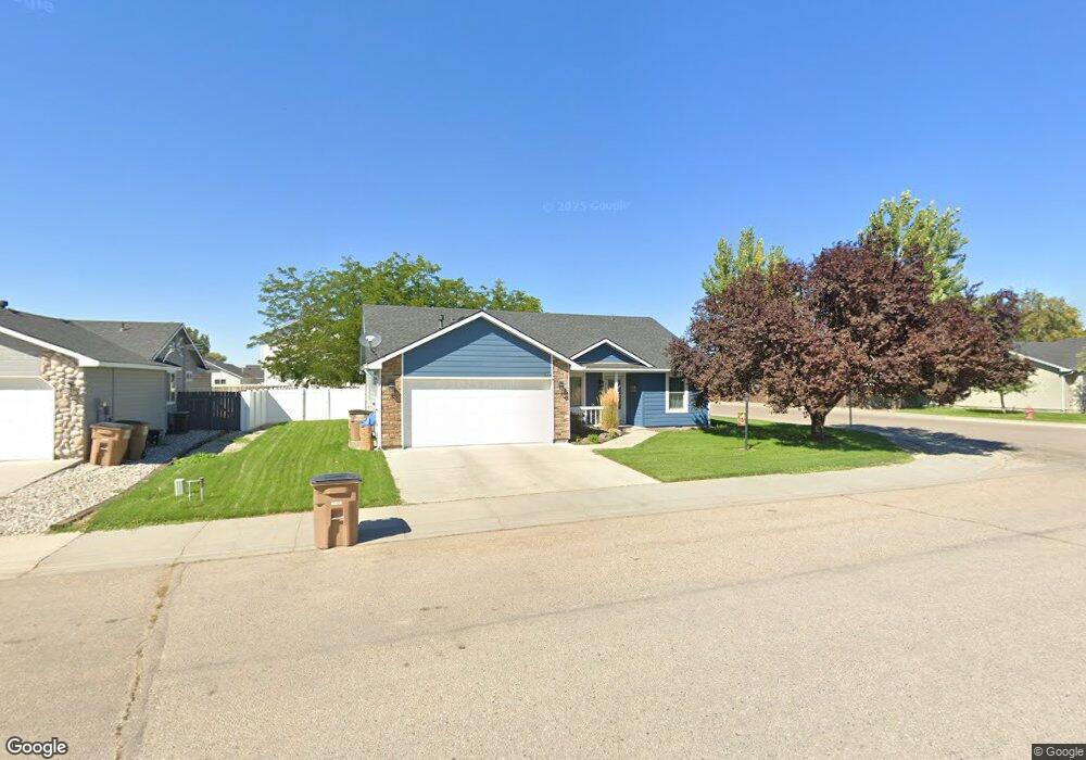
866 W Apache St Emmett, ID 83617
Gem County NeighborhoodEstimated Value: $353,000 - $382,000
3
Beds
2
Baths
1,414
Sq Ft
$258/Sq Ft
Est. Value
About This Home
This home is located at 866 W Apache St, Emmett, ID 83617 and is currently estimated at $364,870, approximately $258 per square foot. 866 W Apache St is a home located in Gem County with nearby schools including Shadow Butte Elementary School and Calvary Christian Academy.
Ownership History
Date
Name
Owned For
Owner Type
Purchase Details
Closed on
Aug 30, 2010
Sold by
Secretary Of Veterans Affairs
Bought by
Boren Dixie L and Clark Jennifer M
Current Estimated Value
Home Financials for this Owner
Home Financials are based on the most recent Mortgage that was taken out on this home.
Original Mortgage
$47,500
Outstanding Balance
$31,247
Interest Rate
4.52%
Mortgage Type
New Conventional
Estimated Equity
$333,623
Purchase Details
Closed on
Mar 30, 2010
Sold by
Wells Fargo Bank Na
Bought by
The Secretary Of Veterans Affairs
Create a Home Valuation Report for This Property
The Home Valuation Report is an in-depth analysis detailing your home's value as well as a comparison with similar homes in the area
Home Values in the Area
Average Home Value in this Area
Purchase History
| Date | Buyer | Sale Price | Title Company |
|---|---|---|---|
| Boren Dixie L | -- | -- | |
| The Secretary Of Veterans Affairs | -- | -- | |
| Wells Fargo Bank Na | $83,724 | -- |
Source: Public Records
Mortgage History
| Date | Status | Borrower | Loan Amount |
|---|---|---|---|
| Open | Boren Dixie L | $47,500 |
Source: Public Records
Tax History
| Year | Tax Paid | Tax Assessment Tax Assessment Total Assessment is a certain percentage of the fair market value that is determined by local assessors to be the total taxable value of land and additions on the property. | Land | Improvement |
|---|---|---|---|---|
| 2025 | $1,254 | $361,819 | $106,891 | $254,928 |
| 2024 | $1,254 | $354,383 | $88,499 | $265,884 |
| 2023 | $1,088 | $358,989 | $72,294 | $286,695 |
| 2021 | $2,368 | $263,758 | $30,900 | $232,858 |
| 2020 | $2,372 | $208,782 | $30,900 | $177,882 |
| 2019 | $2,341 | $204,131 | $30,900 | $173,231 |
| 2018 | $2,202 | $167,141 | $21,600 | $145,541 |
| 2017 | $2,293 | $151,310 | $20,700 | $130,610 |
| 2016 | $2,193 | $136,540 | $19,800 | $116,740 |
Source: Public Records
Map
Nearby Homes
- 810 Sioux Ave
- 819 Sioux Ave
- 1001 Homestead Dr
- 421 W 6th St
- 3890 Birch Ln
- 1510 Strum Ln
- 1424 Mill Rd
- 804 S Commercial Ave
- 206 W 12th St
- 722 S Washington Ave
- 211 W 2nd St
- 824 S Hayes Ave
- 201 W 1st St
- 827 S Wardwell Ave
- 512 S Hayes Ave
- 410 S Hayes Ave
- 816 S Wardwell Ave
- 411 S Wardwell Ave
- 1990 Moonlight Ln
- 1979 Moonlight Ln
- 870 W Apache St
- 0 S Blackfoot
- 872 W Apache St
- 862 W Apache St
- 809 S Cherokee Ave
- 811 S Cherokee Ave
- 815 S Cherokee Ave
- 808 Sioux Ave
- 817 S Cherokee Ave
- 812 Sioux Ave
- 721 Apache St
- 814 Sioux Ave
- 874 W Apache St
- 860 W Apache St
- 873 W Comanche St
- 869 W Comanche St
- 867 W Comanche St
- 865 W Comanche St
- 813 S Cherokee Ave
- 876 W Apache St
Your Personal Tour Guide
Ask me questions while you tour the home.