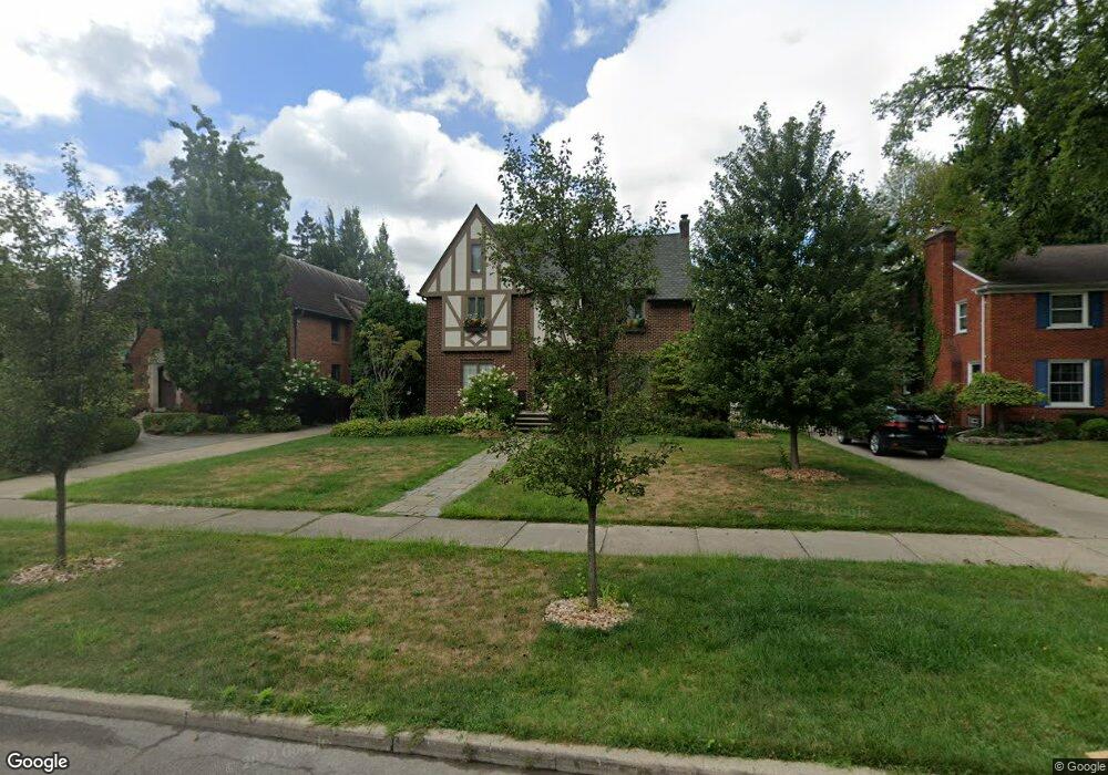
867 Pemberton Rd Grosse Pointe Park, MI 48230
Estimated Value: $552,000 - $911,000
--
Bed
3
Baths
2,336
Sq Ft
$297/Sq Ft
Est. Value
About This Home
This home is located at 867 Pemberton Rd, Grosse Pointe Park, MI 48230 and is currently estimated at $693,690, approximately $296 per square foot. 867 Pemberton Rd is a home located in Wayne County with nearby schools including Pierce Middle School, Grosse Pointe South High School, and Detroit Merit Charter Academy.
Ownership History
Date
Name
Owned For
Owner Type
Purchase Details
Closed on
Mar 2, 2018
Sold by
Costa Frank M
Bought by
Costa Frank M
Current Estimated Value
Purchase Details
Closed on
Oct 9, 2009
Sold by
Costa Susan J S
Bought by
Costa Frank M
Purchase Details
Closed on
Mar 26, 2000
Sold by
Lynch Dennis F
Bought by
Costa Frank M
Purchase Details
Closed on
Mar 16, 1998
Sold by
Breitmeyer Leslie M
Bought by
Lynch Dennis F
Create a Home Valuation Report for This Property
The Home Valuation Report is an in-depth analysis detailing your home's value as well as a comparison with similar homes in the area
Home Values in the Area
Average Home Value in this Area
Purchase History
| Date | Buyer | Sale Price | Title Company |
|---|---|---|---|
| Costa Frank M | -- | None Available | |
| Costa Frank M | -- | None Available | |
| Costa Frank M | $420,000 | -- | |
| Lynch Dennis F | $345,000 | -- |
Source: Public Records
Tax History Compared to Growth
Tax History
| Year | Tax Paid | Tax Assessment Tax Assessment Total Assessment is a certain percentage of the fair market value that is determined by local assessors to be the total taxable value of land and additions on the property. | Land | Improvement |
|---|---|---|---|---|
| 2025 | $4,356 | $281,900 | $0 | $0 |
| 2024 | $4,356 | $267,600 | $0 | $0 |
| 2023 | $4,160 | $237,800 | $0 | $0 |
| 2022 | $3,952 | $221,300 | $0 | $0 |
| 2021 | $7,792 | $218,500 | $0 | $0 |
| 2019 | $8,019 | $198,500 | $0 | $0 |
| 2018 | $3,768 | $169,000 | $0 | $0 |
| 2017 | $8,502 | $139,100 | $0 | $0 |
| 2016 | $7,907 | $168,600 | $0 | $0 |
| 2015 | $14,101 | $161,200 | $0 | $0 |
| 2013 | $13,660 | $139,300 | $0 | $0 |
| 2012 | $3,897 | $147,200 | $42,400 | $104,800 |
Source: Public Records
Map
Nearby Homes
- 847 Barrington Rd
- 709 Ashland St
- 976 Lakepointe St
- 504 Alter Rd
- 784 Barrington Rd
- 908 Manistique St
- 877 Manistique St
- 54 Pointe Park Place Unit 208
- 74 Pointe Park Place Unit 311
- 875 Balfour St
- 14536 E Jefferson Ave
- 709 Lakepointe St
- 888 Marlborough St
- 487 Philip St
- 709 Middlesex Rd
- 1032 Beaconsfield Ave
- 1058 Lakepointe St
- 429 Manistique St
- 1048 Lakepointe St Unit A
- 458 Marlborough St
- 875 Pemberton Rd
- 866 Barrington Rd
- 862 Barrington Rd
- 870 Barrington Rd
- 859 Pemberton Rd
- 860 Barrington Rd
- 881 Pemberton Rd
- 874 Barrington Rd
- 858 Barrington Rd
- 851 Pemberton Rd
- 889 Pemberton Rd
- 888 Barrington Rd
- 856 Barrington Rd
- 843 Pemberton Rd
- 872 Pemberton Rd
- 876 Pemberton Rd
- 867 Barrington Rd Unit 63
- 869 Barrington Rd
- 865 Barrington Rd
- 852 Barrington Rd