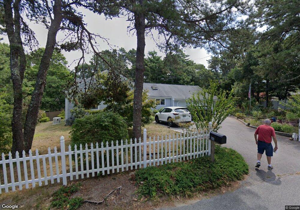
868 Crowells Bog Rd Brewster, MA 02631
Estimated Value: $720,000 - $811,000
3
Beds
2
Baths
1,500
Sq Ft
$508/Sq Ft
Est. Value
About This Home
This home is located at 868 Crowells Bog Rd, Brewster, MA 02631 and is currently estimated at $761,306, approximately $507 per square foot. 868 Crowells Bog Rd is a home located in Barnstable County with nearby schools including Nauset Regional Middle School, Nauset Regional High School, and Cape Cod Lighthouse Charter School.
Ownership History
Date
Name
Owned For
Owner Type
Purchase Details
Closed on
Oct 12, 2005
Sold by
Kuipers Cindy L and Kuipers Donald
Bought by
Chmielewski Carol and Manley Michael
Current Estimated Value
Home Financials for this Owner
Home Financials are based on the most recent Mortgage that was taken out on this home.
Original Mortgage
$345,500
Interest Rate
5.78%
Mortgage Type
Purchase Money Mortgage
Purchase Details
Closed on
May 16, 2005
Sold by
Crowells Bog Rt and Hoogland Bernard
Bought by
Kuipers Cindy Lu and Kuipers Donald
Purchase Details
Closed on
Sep 30, 1998
Sold by
Caron Mark W and Caron Laurie M
Bought by
Everett Lucille T
Create a Home Valuation Report for This Property
The Home Valuation Report is an in-depth analysis detailing your home's value as well as a comparison with similar homes in the area
Home Values in the Area
Average Home Value in this Area
Purchase History
| Date | Buyer | Sale Price | Title Company |
|---|---|---|---|
| Chmielewski Carol | $431,900 | -- | |
| Kuipers Cindy Lu | -- | -- | |
| Everett Lucille T | $174,000 | -- |
Source: Public Records
Mortgage History
| Date | Status | Borrower | Loan Amount |
|---|---|---|---|
| Open | Everett Lucille T | $328,000 | |
| Closed | Chmielewski Carol | $345,500 |
Source: Public Records
Tax History Compared to Growth
Tax History
| Year | Tax Paid | Tax Assessment Tax Assessment Total Assessment is a certain percentage of the fair market value that is determined by local assessors to be the total taxable value of land and additions on the property. | Land | Improvement |
|---|---|---|---|---|
| 2025 | $5,137 | $746,600 | $319,100 | $427,500 |
| 2024 | $4,800 | $704,900 | $301,000 | $403,900 |
| 2023 | $4,435 | $634,500 | $268,700 | $365,800 |
| 2022 | $4,169 | $531,100 | $223,900 | $307,200 |
| 2021 | $4,000 | $466,200 | $194,600 | $271,600 |
| 2020 | $3,909 | $453,500 | $194,600 | $258,900 |
| 2019 | $3,812 | $439,900 | $187,200 | $252,700 |
| 2018 | $3,553 | $430,100 | $187,200 | $242,900 |
| 2017 | $3,415 | $401,000 | $187,200 | $213,800 |
| 2016 | $3,420 | $405,700 | $195,800 | $209,900 |
| 2015 | $3,297 | $399,200 | $191,900 | $207,300 |
Source: Public Records
Map
Nearby Homes
- 33 Captain William Arthur Rd
- 958 Long Pond Rd
- 43 Billington Ln
- 43 Billington Ln Unit 43
- 274 Commons Way
- 55 Leona Terrace
- 737 Thousand Oaks Dr
- 96 Eaton Ln Unit 96
- 78 Eaton Ln Unit 78
- 78 Eaton Ln
- 30 Fox Crossing Rd
- 52 Eaton Ln Unit (52)
- 52 Bettys Ln
- 63 Trevor Ln Unit 63
- 16 Commons Way
- 82 Fletcher Ln Unit I
- 0 Commons Way Unit 22504099
- 46 Court Way
- 765 Millstone Rd
- 60 Fletcher Ln Unit H
- 868 Crowell's Bog Rd
- 32 Woodward Rd
- 5 Long Pond Cir
- 8 Woodward Rd
- 42 Woodward Rd
- 183 Sheep Pond Cir
- 873 Crowells Bog Rd
- 17 Long Pond Cir
- 52 Woodward Rd
- 29 Woodward Rd
- 0 Woodward Rd
- 882 Crowells Bog Rd
- 21 Woodward Rd
- 15 Marion Ln
- 43 Woodward Rd
- 896 Crowells Bog Rd
- 112 Tanglewood Rd
- 169 Sheep Pond Cir
- 62 Woodward Rd
- 21 Marion Ln