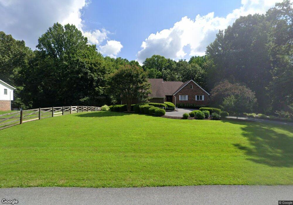
8690 Norman Dr White Plains, MD 20695
Estimated Value: $541,023 - $636,000
--
Bed
2
Baths
3,381
Sq Ft
$168/Sq Ft
Est. Value
About This Home
This home is located at 8690 Norman Dr, White Plains, MD 20695 and is currently estimated at $567,756, approximately $167 per square foot. 8690 Norman Dr is a home located in Charles County with nearby schools including Dr. James Craik Elementary School, Matthew Henson Middle School, and Maurice J. McDonough High School.
Ownership History
Date
Name
Owned For
Owner Type
Purchase Details
Closed on
Dec 1, 1992
Sold by
Thompson Robert A
Bought by
Sharper Frank and Sharper Maricar F
Current Estimated Value
Purchase Details
Closed on
Aug 3, 1984
Sold by
Hunt Robert V and Hunt Joanne C
Bought by
Thompson Robert A
Purchase Details
Closed on
Jan 19, 1981
Sold by
Robie William F and Robie Kathleen L
Bought by
Hunt Robert and Hunt Joanne C
Home Financials for this Owner
Home Financials are based on the most recent Mortgage that was taken out on this home.
Original Mortgage
$13,750
Interest Rate
14.85%
Create a Home Valuation Report for This Property
The Home Valuation Report is an in-depth analysis detailing your home's value as well as a comparison with similar homes in the area
Home Values in the Area
Average Home Value in this Area
Purchase History
| Date | Buyer | Sale Price | Title Company |
|---|---|---|---|
| Sharper Frank | $275,000 | -- | |
| Thompson Robert A | $21,000 | -- | |
| Hunt Robert | $18,500 | -- |
Source: Public Records
Mortgage History
| Date | Status | Borrower | Loan Amount |
|---|---|---|---|
| Previous Owner | Hunt Robert | $13,750 |
Source: Public Records
Tax History Compared to Growth
Tax History
| Year | Tax Paid | Tax Assessment Tax Assessment Total Assessment is a certain percentage of the fair market value that is determined by local assessors to be the total taxable value of land and additions on the property. | Land | Improvement |
|---|---|---|---|---|
| 2025 | -- | $534,000 | $151,100 | $382,900 |
| 2024 | $7,100 | $510,133 | $0 | $0 |
| 2023 | $6,949 | $486,267 | $0 | $0 |
| 2022 | $6,418 | $462,400 | $131,100 | $331,300 |
| 2021 | $6,294 | $459,167 | $0 | $0 |
| 2020 | $6,294 | $455,933 | $0 | $0 |
| 2019 | $6,239 | $452,700 | $131,100 | $321,600 |
| 2018 | $5,926 | $432,400 | $0 | $0 |
| 2017 | $5,650 | $412,100 | $0 | $0 |
| 2016 | -- | $391,800 | $0 | $0 |
| 2015 | $4,447 | $384,033 | $0 | $0 |
| 2014 | $4,447 | $376,267 | $0 | $0 |
Source: Public Records
Map
Nearby Homes
- 4065 Lee Ln
- 0 Billingsley Rd Unit MDCH2041862
- The Lexington Plan at Bensville Crossing
- 3801 Solidarity Cir
- 3800 Solidarity Cir
- 3804 Solidarity Cir
- 3796 Solidarity Cir
- 3812 Solidarity Cir
- 3785 Solidarity Cir
- 8630 Resilience St
- 8625 Resilience St
- 3827 Solidarity Cir
- 3831 Solidarity Cir
- 3839 Solidarity Cir
- 3868 Kahler Rd
- 8633 Resilience St
- 8629 Resilience St
- 8625 Resilience St
- 0 Robie Bensville Rd Unit MDCH2047354
- 8201 Bishopsgate Ln