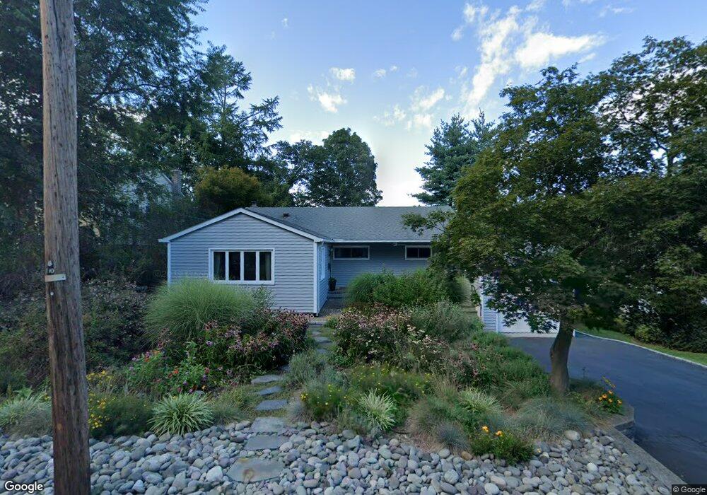
87 Barnes Rd Tarrytown, NY 10591
Estimated Value: $844,000 - $1,114,000
3
Beds
2
Baths
1,700
Sq Ft
$575/Sq Ft
Est. Value
About This Home
This home is located at 87 Barnes Rd, Tarrytown, NY 10591 and is currently estimated at $977,040, approximately $574 per square foot. 87 Barnes Rd is a home located in Westchester County with nearby schools including Washington Irving Interm School, John Paulding School, and W L Morse School.
Ownership History
Date
Name
Owned For
Owner Type
Purchase Details
Closed on
Apr 30, 2009
Sold by
Silverman Andrew J and Silverman Tarja
Bought by
Venturini Joseph and Venturini Roseann Lehmann
Current Estimated Value
Home Financials for this Owner
Home Financials are based on the most recent Mortgage that was taken out on this home.
Original Mortgage
$401,400
Outstanding Balance
$253,614
Interest Rate
4.85%
Mortgage Type
Purchase Money Mortgage
Estimated Equity
$723,426
Create a Home Valuation Report for This Property
The Home Valuation Report is an in-depth analysis detailing your home's value as well as a comparison with similar homes in the area
Home Values in the Area
Average Home Value in this Area
Purchase History
| Date | Buyer | Sale Price | Title Company |
|---|---|---|---|
| Venturini Joseph | $446,000 | Fidelity Natl Title Ins Co |
Source: Public Records
Mortgage History
| Date | Status | Borrower | Loan Amount |
|---|---|---|---|
| Open | Venturini Joseph | $401,400 |
Source: Public Records
Tax History
| Year | Tax Paid | Tax Assessment Tax Assessment Total Assessment is a certain percentage of the fair market value that is determined by local assessors to be the total taxable value of land and additions on the property. | Land | Improvement |
|---|---|---|---|---|
| 2024 | $19,176 | $817,600 | $280,900 | $536,700 |
| 2023 | $19,970 | $738,600 | $248,600 | $490,000 |
| 2022 | $19,145 | $682,200 | $248,600 | $433,600 |
| 2021 | $18,071 | $619,700 | $248,600 | $371,100 |
| 2020 | $17,940 | $571,400 | $248,600 | $322,800 |
| 2019 | $19,054 | $571,400 | $248,600 | $322,800 |
| 2018 | $20,596 | $561,100 | $248,600 | $312,500 |
| 2017 | $9,195 | $535,400 | $248,600 | $286,800 |
| 2016 | $379,145 | $514,800 | $248,600 | $266,200 |
| 2015 | -- | $15,110 | $1,950 | $13,160 |
| 2014 | -- | $15,110 | $1,950 | $13,160 |
| 2013 | $9,644 | $15,110 | $1,950 | $13,160 |
Source: Public Records
Map
Nearby Homes
- 117 Crest Dr
- 43 Putnam Ave
- 14 Croton Ave
- 27 Loh Ave
- 222 Martling Ave Unit 3R
- 349 Martling Ave
- 93 Carrollwood Dr Unit 93
- 103 Carrollwood Dr
- 410 Benedict Ave Unit 5E
- 19 S Broadway Unit 4A
- 46 Trailhead Ln
- 154 Martling Ave Unit G3
- 154 Martling Ave Unit 5-J6
- 57 Cobb Ln
- 23 Windle Park Unit B
- 103 Old White Plains Rd
- 10 Tappan Landing Rd Unit 53A
- 300 S Broadway Unit 6-H
- 320 S Broadway Unit P8
- 330 S Broadway Unit E9
Your Personal Tour Guide
Ask me questions while you tour the home.