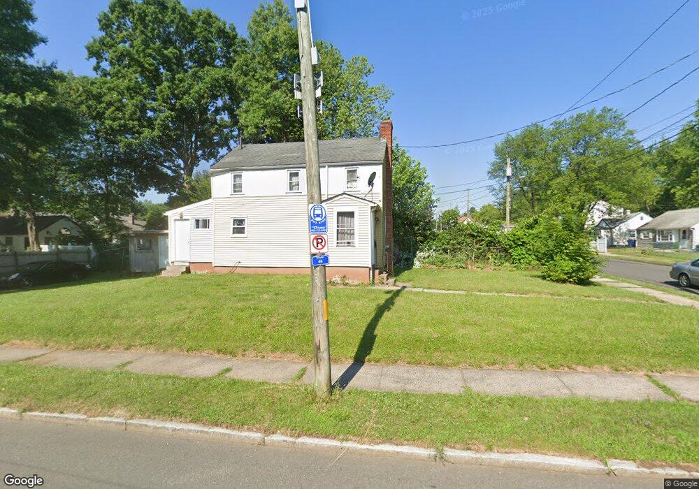
87 E Euclid St Hartford, CT 06112
Blue Hills NeighborhoodEstimated Value: $202,000 - $233,220
2
Beds
1
Bath
946
Sq Ft
$234/Sq Ft
Est. Value
About This Home
This home is located at 87 E Euclid St, Hartford, CT 06112 and is currently estimated at $221,073, approximately $233 per square foot. 87 E Euclid St is a home located in Hartford County with nearby schools including Rawson School, Noah Webster Micro Society School, and McKinley School.
Ownership History
Date
Name
Owned For
Owner Type
Purchase Details
Closed on
Mar 23, 2023
Sold by
Edward Gery N and Edward Candy
Bought by
Edward Gery N
Current Estimated Value
Purchase Details
Closed on
Aug 7, 2002
Sold by
Bankers T Co
Bought by
Edwards Candy
Home Financials for this Owner
Home Financials are based on the most recent Mortgage that was taken out on this home.
Original Mortgage
$57,000
Interest Rate
6.02%
Mortgage Type
Purchase Money Mortgage
Create a Home Valuation Report for This Property
The Home Valuation Report is an in-depth analysis detailing your home's value as well as a comparison with similar homes in the area
Home Values in the Area
Average Home Value in this Area
Purchase History
| Date | Buyer | Sale Price | Title Company |
|---|---|---|---|
| Edward Gery N | -- | None Available | |
| Edwards Candy | $60,000 | -- |
Source: Public Records
Mortgage History
| Date | Status | Borrower | Loan Amount |
|---|---|---|---|
| Previous Owner | Edwards Candy | $84,000 | |
| Previous Owner | Edwards Candy | $57,000 | |
| Previous Owner | Edwards Candy | $56,000 |
Source: Public Records
Tax History Compared to Growth
Tax History
| Year | Tax Paid | Tax Assessment Tax Assessment Total Assessment is a certain percentage of the fair market value that is determined by local assessors to be the total taxable value of land and additions on the property. | Land | Improvement |
|---|---|---|---|---|
| 2025 | $3,955 | $57,367 | $4,594 | $52,773 |
| 2024 | $3,955 | $57,367 | $4,594 | $52,773 |
| 2023 | $3,955 | $57,367 | $4,594 | $52,773 |
| 2022 | $3,955 | $57,367 | $4,594 | $52,773 |
| 2021 | $2,577 | $34,685 | $5,495 | $29,190 |
| 2020 | $2,577 | $34,685 | $5,495 | $29,190 |
| 2019 | $2,577 | $34,685 | $5,495 | $29,190 |
| 2018 | $2,490 | $33,516 | $5,310 | $28,206 |
| 2016 | $2,551 | $34,336 | $5,057 | $29,279 |
| 2015 | $2,430 | $32,705 | $4,817 | $27,888 |
| 2014 | $2,370 | $31,905 | $4,699 | $27,206 |
Source: Public Records
Map
Nearby Homes
- 97 E Burnham St
- 97 Boothbay St
- 125 Lebanon St Unit 127
- 117 E Harold St
- 13 Patton Rd
- 52 Greenwood Ave
- 67 Elizabeth Ave
- 36 Baltic St Unit 38
- 10 Baltic St Unit 12
- 175 E Pershing St
- 11 Pershing St Unit 13
- 70 Burnham St Unit 72
- 77 Harold St
- 86 Hartland St
- 147 Morningside St W
- 90 Manchester St
- 355 Cornwall St Unit 357
- 180 Brookline Ave
- 171 N Canaan St
- 218 Holcomb St Unit 220
- 83 E Euclid St
- 79 E Euclid St
- 84 E Euclid St
- 89 E Euclid St
- 80 E Euclid St
- 88 E Burnham St
- 84 E Burnham St
- 75 E Euclid St
- 76 E Euclid St
- 80 E Burnham St
- 76 E Burnham St
- 90 E Burnham St
- 94 E Euclid St
- 70 E Euclid St Unit 72
- 72 E Burnham St
- 97 E Euclid St
- 67 E Euclid St
- 305 Coventry St
- 313 Coventry St
- 94 E Burnham St