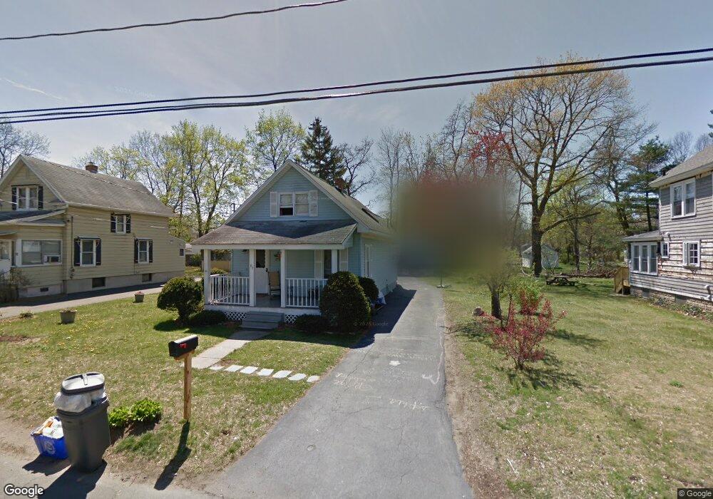
87 Meadow Rd Longmeadow, MA 01106
Estimated Value: $353,000 - $395,227
3
Beds
2
Baths
1,064
Sq Ft
$360/Sq Ft
Est. Value
About This Home
This home is located at 87 Meadow Rd, Longmeadow, MA 01106 and is currently estimated at $382,557, approximately $359 per square foot. 87 Meadow Rd is a home located in Hampden County with nearby schools including Wolf Swamp Road School, Glenbrook Middle School, and Longmeadow High School.
Ownership History
Date
Name
Owned For
Owner Type
Purchase Details
Closed on
Nov 22, 2004
Sold by
Mahmud-Rizvi Syed Asad
Bought by
Srebnick Brian
Current Estimated Value
Home Financials for this Owner
Home Financials are based on the most recent Mortgage that was taken out on this home.
Original Mortgage
$160,000
Outstanding Balance
$79,952
Interest Rate
5.8%
Mortgage Type
Purchase Money Mortgage
Estimated Equity
$302,605
Purchase Details
Closed on
Aug 24, 1999
Sold by
Kakley Gary M and Kakley Jennifer K
Bought by
Rizvi Syed A and Rizvi Syeda L
Home Financials for this Owner
Home Financials are based on the most recent Mortgage that was taken out on this home.
Original Mortgage
$106,875
Interest Rate
7.6%
Mortgage Type
Purchase Money Mortgage
Purchase Details
Closed on
Dec 31, 1987
Sold by
Clarke Winifred M
Bought by
Kakley Gary M
Create a Home Valuation Report for This Property
The Home Valuation Report is an in-depth analysis detailing your home's value as well as a comparison with similar homes in the area
Home Values in the Area
Average Home Value in this Area
Purchase History
| Date | Buyer | Sale Price | Title Company |
|---|---|---|---|
| Srebnick Brian | $200,000 | -- | |
| Rizvi Syed A | $112,500 | -- | |
| Kakley Gary M | $92,000 | -- |
Source: Public Records
Mortgage History
| Date | Status | Borrower | Loan Amount |
|---|---|---|---|
| Open | Srebnick Brian | $160,000 | |
| Closed | Srebnick Brian | $40,000 | |
| Previous Owner | Kakley Gary M | $106,875 | |
| Previous Owner | Kakley Gary M | $21,400 | |
| Previous Owner | Kakley Gary M | $93,000 |
Source: Public Records
Tax History Compared to Growth
Tax History
| Year | Tax Paid | Tax Assessment Tax Assessment Total Assessment is a certain percentage of the fair market value that is determined by local assessors to be the total taxable value of land and additions on the property. | Land | Improvement |
|---|---|---|---|---|
| 2025 | $6,545 | $309,900 | $144,700 | $165,200 |
| 2024 | $5,056 | $244,500 | $144,700 | $99,800 |
| 2023 | $5,026 | $219,300 | $116,600 | $102,700 |
| 2022 | $5,029 | $204,100 | $116,600 | $87,500 |
| 2021 | $4,884 | $197,400 | $117,900 | $79,500 |
| 2020 | $4,796 | $198,100 | $111,000 | $87,100 |
| 2019 | $4,633 | $192,300 | $111,000 | $81,300 |
| 2018 | $4,617 | $189,700 | $129,500 | $60,200 |
| 2017 | $4,473 | $189,700 | $129,500 | $60,200 |
| 2016 | $4,491 | $184,600 | $122,900 | $61,700 |
| 2015 | $4,386 | $185,700 | $121,700 | $64,000 |
Source: Public Records
Map
Nearby Homes