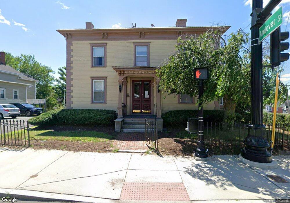
87 Nesmith St Lowell, MA 01852
Belvidere NeighborhoodEstimated Value: $706,000 - $852,000
5
Beds
5
Baths
3,224
Sq Ft
$240/Sq Ft
Est. Value
About This Home
This home is located at 87 Nesmith St, Lowell, MA 01852 and is currently estimated at $773,987, approximately $240 per square foot. 87 Nesmith St is a home located in Middlesex County with nearby schools including Moody Elementary School, Abraham Lincoln Elementary School, and Greenhalge Elementary School.
Ownership History
Date
Name
Owned For
Owner Type
Purchase Details
Closed on
Oct 15, 2010
Sold by
Freitas Paul A and Freitas Florence E
Bought by
Nesmith Mass Comm Of L
Current Estimated Value
Home Financials for this Owner
Home Financials are based on the most recent Mortgage that was taken out on this home.
Original Mortgage
$272,000
Outstanding Balance
$179,582
Interest Rate
4.36%
Mortgage Type
Commercial
Estimated Equity
$594,405
Purchase Details
Closed on
Feb 16, 1989
Sold by
Comfed Sb
Bought by
Freitas Paul A
Create a Home Valuation Report for This Property
The Home Valuation Report is an in-depth analysis detailing your home's value as well as a comparison with similar homes in the area
Home Values in the Area
Average Home Value in this Area
Purchase History
| Date | Buyer | Sale Price | Title Company |
|---|---|---|---|
| Nesmith Mass Comm Of L | $340,000 | -- | |
| Nesmith Mass Comm Of L | $340,000 | -- | |
| Freitas Paul A | $235,000 | -- | |
| Freitas Paul A | $235,000 | -- |
Source: Public Records
Mortgage History
| Date | Status | Borrower | Loan Amount |
|---|---|---|---|
| Open | Nesmith Mass Comm Of L | $272,000 | |
| Closed | Freitas Paul A | $272,000 | |
| Previous Owner | Freitas Paul A | $200,000 | |
| Previous Owner | Freitas Paul A | $275,000 |
Source: Public Records
Tax History
| Year | Tax Paid | Tax Assessment Tax Assessment Total Assessment is a certain percentage of the fair market value that is determined by local assessors to be the total taxable value of land and additions on the property. | Land | Improvement |
|---|---|---|---|---|
| 2025 | $7,891 | $687,400 | $250,500 | $436,900 |
| 2024 | $7,993 | $671,100 | $234,200 | $436,900 |
| 2023 | $7,548 | $607,700 | $203,600 | $404,100 |
| 2022 | $6,867 | $541,100 | $185,100 | $356,000 |
| 2021 | $6,428 | $477,600 | $160,900 | $316,700 |
| 2020 | $6,206 | $464,500 | $160,900 | $303,600 |
| 2019 | $5,821 | $414,600 | $160,100 | $254,500 |
| 2018 | $5,773 | $401,200 | $152,500 | $248,700 |
| 2017 | $5,589 | $374,600 | $141,600 | $233,000 |
| 2016 | $5,506 | $363,200 | $130,200 | $233,000 |
| 2015 | $5,259 | $339,700 | $130,200 | $209,500 |
| 2013 | $4,947 | $329,600 | $143,700 | $185,900 |
Source: Public Records
Map
Nearby Homes
- 88 Perry St
- 234 Nesmith St Unit 8
- 250 Nesmith St Unit 11
- 44 Hanks St
- 128 Warren St Unit 12
- 200 Rogers St Unit 6
- 80 Rogers St Unit 204
- 39 Groves Ave
- 313 Nesmith St
- 8 Clarks Ct
- 254 Pleasant St
- 42 Pentucket Ave
- 31 Merrill St
- 192 1st St
- 11 Cottage St
- 17 Kearney Square Unit 201
- 21 Vernon St
- 94 1st St Unit 10
- 105 3rd St
- 25 Read St
- 185 Andover St
- 95 Nesmith St Unit 3
- 95 Nesmith St Unit 1
- 95 Nesmith St Unit 2
- 95 Nesmith St
- 22 Harrison St Unit D
- 22 Harrison St Unit C
- 22 Harrison St Unit B
- 22 Harrison St Unit A
- 22 Harrison St Unit 1
- 22 Harrison St Unit 2
- 22 Harrison St Unit 4 / D
- 20 Harrison St Unit 3
- 20 Harrison St Unit 4
- 73 Nesmith St Unit 4
- 73 Nesmith St Unit 1
- 73 Nesmith St Unit 2
- 73 Nesmith St
- 105 Nesmith St Unit C
- 105 Nesmith St Unit A
Your Personal Tour Guide
Ask me questions while you tour the home.