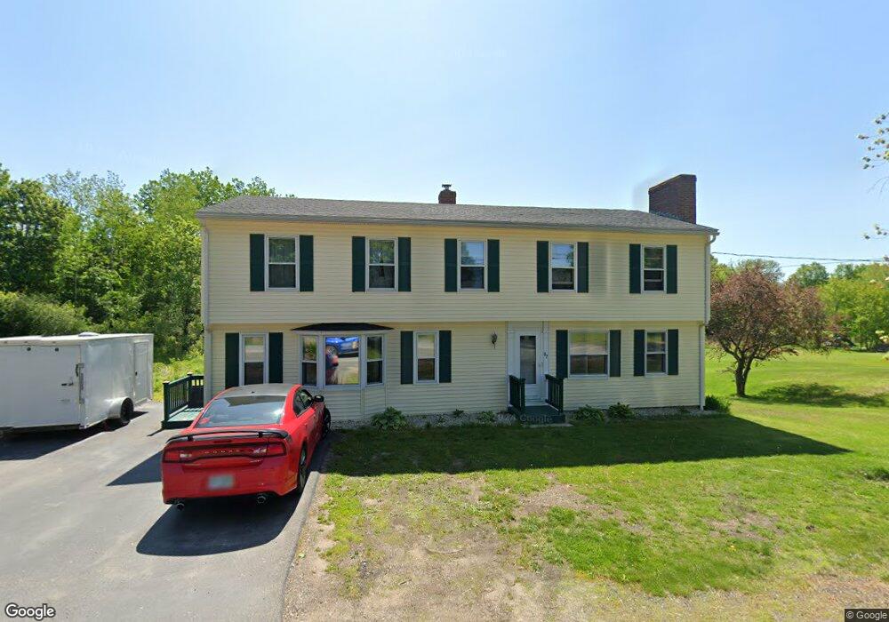
87 Rollins Rd Rollinsford, NH 03869
Estimated Value: $436,000 - $549,000
3
Beds
2
Baths
2,497
Sq Ft
$206/Sq Ft
Est. Value
About This Home
This home is located at 87 Rollins Rd, Rollinsford, NH 03869 and is currently estimated at $514,539, approximately $206 per square foot. 87 Rollins Rd is a home located in Strafford County with nearby schools including Rollinsford Grade School, St Mary Academy, and My School.
Ownership History
Date
Name
Owned For
Owner Type
Purchase Details
Closed on
Sep 12, 2023
Sold by
Hakes Kelly L and Boyd Joseph D
Bought by
Mirabal Ademi and Mirabal Katlynne
Current Estimated Value
Home Financials for this Owner
Home Financials are based on the most recent Mortgage that was taken out on this home.
Original Mortgage
$208,000
Outstanding Balance
$203,539
Interest Rate
6.9%
Mortgage Type
Purchase Money Mortgage
Estimated Equity
$311,000
Purchase Details
Closed on
Oct 22, 2021
Sold by
Porter Allen W and Porter Tamia M
Bought by
Hakes Kelly L and Boyd Joseph D
Home Financials for this Owner
Home Financials are based on the most recent Mortgage that was taken out on this home.
Original Mortgage
$295,000
Interest Rate
2.8%
Mortgage Type
Purchase Money Mortgage
Create a Home Valuation Report for This Property
The Home Valuation Report is an in-depth analysis detailing your home's value as well as a comparison with similar homes in the area
Home Values in the Area
Average Home Value in this Area
Purchase History
| Date | Buyer | Sale Price | Title Company |
|---|---|---|---|
| Mirabal Ademi | $476,000 | None Available | |
| Hakes Kelly L | $385,000 | None Available |
Source: Public Records
Mortgage History
| Date | Status | Borrower | Loan Amount |
|---|---|---|---|
| Open | Mirabal Ademi | $208,000 | |
| Previous Owner | Hakes Kelly L | $295,000 |
Source: Public Records
Tax History Compared to Growth
Tax History
| Year | Tax Paid | Tax Assessment Tax Assessment Total Assessment is a certain percentage of the fair market value that is determined by local assessors to be the total taxable value of land and additions on the property. | Land | Improvement |
|---|---|---|---|---|
| 2024 | $6,526 | $397,700 | $162,800 | $234,900 |
| 2023 | $6,117 | $397,700 | $162,800 | $234,900 |
| 2022 | $5,914 | $397,700 | $162,800 | $234,900 |
| 2021 | $6,780 | $278,100 | $99,200 | $178,900 |
| 2020 | $6,864 | $278,100 | $99,200 | $178,900 |
| 2019 | $6,288 | $278,100 | $99,200 | $178,900 |
| 2018 | $6,713 | $278,100 | $99,200 | $178,900 |
| 2016 | $7,283 | $260,300 | $93,100 | $167,200 |
| 2015 | $7,140 | $260,300 | $93,100 | $167,200 |
| 2014 | $6,898 | $260,300 | $93,100 | $167,200 |
| 2013 | $6,997 | $260,300 | $93,100 | $167,200 |
Source: Public Records
Map
Nearby Homes
- 34 Floral Ave Unit 5
- 36 Oak St
- 725 Central Ave Unit 203
- 725 Central Ave Unit LL03
- 725 Central Ave Unit 301
- 725 Central Ave Unit 302
- 725 Central Ave Unit LL01
- 725 Central Ave Unit 304
- 713 Central Ave Unit 1
- Lot 6 Emerson Ridge Unit 6
- 96 Broadway Unit 98
- 815 Central Ave
- Lot 8 Emerson Ridge Unit 8
- 24 Atlantic Ave
- 27 Atlantic Ave
- 23 Townsend Dr
- 45 New York St Unit 8
- 39 New York St
- 11 Country Club Estates Dr Unit 11
- 46-50 Cocheco St