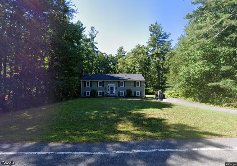
87 Wildcat Ln Norwell, MA 02061
Estimated Value: $890,509 - $1,060,000
3
Beds
3
Baths
2,532
Sq Ft
$379/Sq Ft
Est. Value
About This Home
This home is located at 87 Wildcat Ln, Norwell, MA 02061 and is currently estimated at $958,877, approximately $378 per square foot. 87 Wildcat Ln is a home located in Plymouth County with nearby schools including Grace Farrar Cole Elementary School, Norwell Middle School, and Norwell High School.
Ownership History
Date
Name
Owned For
Owner Type
Purchase Details
Closed on
Jul 3, 2007
Sold by
Murphy Rosella and Noone Rosella
Bought by
Dibella Albert S and Dibella Lita
Current Estimated Value
Purchase Details
Closed on
Apr 19, 1994
Sold by
Household Fin Corp Ii
Bought by
Murphy Timothy and Murphy Rosella
Purchase Details
Closed on
Oct 19, 1993
Sold by
Weinstock William J and Weinstock Suzanne M
Bought by
Household Finance Corp
Create a Home Valuation Report for This Property
The Home Valuation Report is an in-depth analysis detailing your home's value as well as a comparison with similar homes in the area
Home Values in the Area
Average Home Value in this Area
Purchase History
| Date | Buyer | Sale Price | Title Company |
|---|---|---|---|
| Dibella Albert S | $484,000 | -- | |
| Dibella Albert S | $484,000 | -- | |
| Murphy Timothy | $180,000 | -- | |
| Household Finance Corp | $155,000 | -- |
Source: Public Records
Mortgage History
| Date | Status | Borrower | Loan Amount |
|---|---|---|---|
| Open | Household Finance Corp | $379,000 |
Source: Public Records
Tax History Compared to Growth
Tax History
| Year | Tax Paid | Tax Assessment Tax Assessment Total Assessment is a certain percentage of the fair market value that is determined by local assessors to be the total taxable value of land and additions on the property. | Land | Improvement |
|---|---|---|---|---|
| 2025 | $9,085 | $695,100 | $433,900 | $261,200 |
| 2024 | $9,581 | $711,800 | $409,400 | $302,400 |
| 2023 | $8,839 | $578,100 | $300,500 | $277,600 |
| 2022 | $8,973 | $539,900 | $273,600 | $266,300 |
| 2021 | $6,134 | $497,400 | $288,000 | $209,400 |
| 2020 | $8,576 | $515,700 | $293,200 | $222,500 |
| 2019 | $5,382 | $505,300 | $282,800 | $222,500 |
| 2018 | $7,807 | $477,800 | $288,000 | $189,800 |
| 2017 | $5,159 | $448,000 | $274,900 | $173,100 |
| 2016 | $7,097 | $430,100 | $274,900 | $155,200 |
| 2015 | $6,531 | $395,800 | $274,900 | $120,900 |
| 2014 | $6,761 | $413,000 | $288,600 | $124,400 |
Source: Public Records
Map
Nearby Homes
- 198 Pine St
- 301 Pine St
- 37 Tara Dr
- 2 Curtis Farm Rd
- 260 River St
- 250 River St
- 205 Pleasant St
- 28 Riverside Dr
- 72 Chittenden Ln
- 11 Silver Brook Ln Unit 11
- 555 River St
- 451 Main St
- 0 Island View Cir
- 14 Longwood Ln Unit 14
- 114 Main St
- 20 Meadow Brook Rd
- 479 Clapp Brook Rd
- 179 Lincoln St
- 61 Deborah Rd
- Lot 26 Webster Farm Way
- 79 Wildcat Ln
- 90 Wildcat Ln
- 96 Wildcat Ln
- 84 Wildcat Ln
- 75 Wildcat Ln
- 78 Wildcat Ln
- 5 Old Pottery Ln
- 107 Wildcat Ln
- 72 Wildcat Ln
- 14 Old Pottery Ln
- 26 Old Pottery Ln
- 65 Wildcat Ln
- 32 Old Pottery Ln
- 11 Old Pottery Ln
- 7 John Neil Dr
- 17 Old Pottery Ln
- 55 Wildcat Ln
- 38 Old Pottery Ln
- 15 John Neil Dr
- 23 John Neil Dr