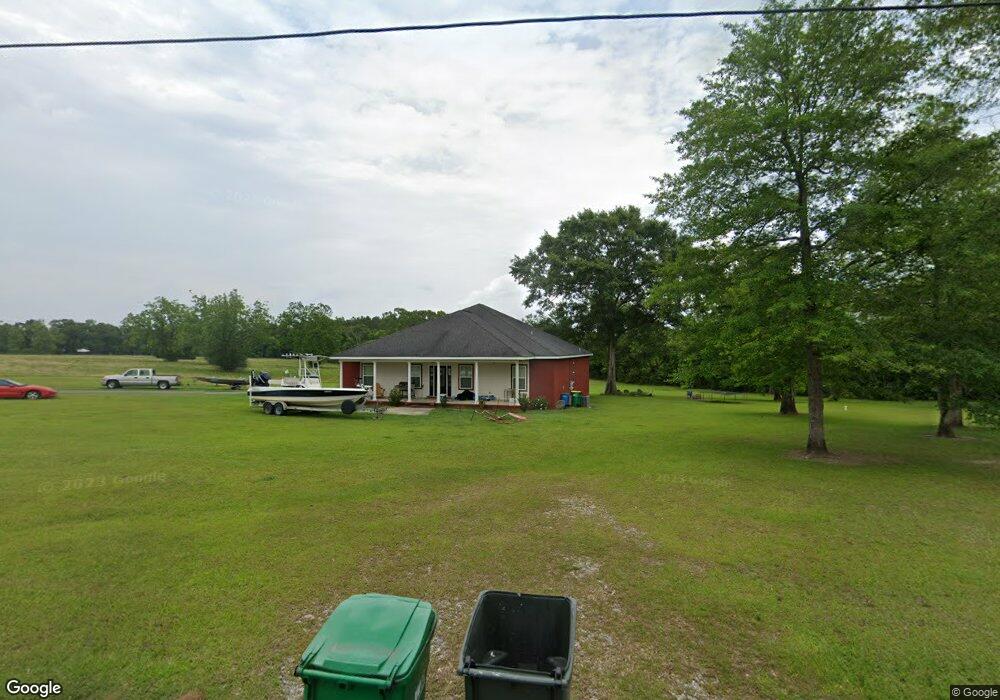
8700 Wire Rd Vancleave, MS 39565
Estimated Value: $276,850 - $368,000
Studio
--
Bath
2,250
Sq Ft
$138/Sq Ft
Est. Value
About This Home
This home is located at 8700 Wire Rd, Vancleave, MS 39565 and is currently estimated at $310,963, approximately $138 per square foot. 8700 Wire Rd is a home with nearby schools including Vancleave Upper Elementary School, Vancleave Lower Elementary School, and Vancleave Middle School.
Ownership History
Date
Name
Owned For
Owner Type
Purchase Details
Closed on
Apr 29, 2020
Sold by
Furby Jerry W and Furby Cayla D
Bought by
Furby Jerry W and Furby Cayla D
Current Estimated Value
Home Financials for this Owner
Home Financials are based on the most recent Mortgage that was taken out on this home.
Original Mortgage
$185,600
Outstanding Balance
$126,000
Interest Rate
3.3%
Mortgage Type
New Conventional
Estimated Equity
$184,963
Create a Home Valuation Report for This Property
The Home Valuation Report is an in-depth analysis detailing your home's value as well as a comparison with similar homes in the area
Purchase History
| Date | Buyer | Sale Price | Title Company |
|---|---|---|---|
| Furby Jerry W | -- | None Available |
Source: Public Records
Mortgage History
| Date | Status | Borrower | Loan Amount |
|---|---|---|---|
| Open | Furby Jerry W | $185,600 |
Source: Public Records
Tax History
| Year | Tax Paid | Tax Assessment Tax Assessment Total Assessment is a certain percentage of the fair market value that is determined by local assessors to be the total taxable value of land and additions on the property. | Land | Improvement |
|---|---|---|---|---|
| 2025 | $1,767 | $17,400 | $1,458 | $15,942 |
| 2024 | $1,767 | $14,761 | $1,418 | $13,343 |
| 2023 | $1,472 | $14,761 | $1,418 | $13,343 |
| 2022 | $1,422 | $14,761 | $1,418 | $13,343 |
| 2021 | $1,429 | $14,835 | $1,418 | $13,417 |
| 2020 | $1,431 | $14,330 | $1,002 | $13,328 |
| 2019 | $1,412 | $14,330 | $1,002 | $13,328 |
| 2018 | $1,446 | $14,330 | $1,002 | $13,328 |
| 2017 | $1,475 | $14,330 | $1,002 | $13,328 |
| 2016 | $1,405 | $14,330 | $1,002 | $13,328 |
| 2015 | $1,259 | $130,370 | $7,840 | $122,530 |
| 2014 | $1,293 | $13,562 | $784 | $12,778 |
| 2013 | $1,240 | $13,562 | $784 | $12,778 |
Source: Public Records
Map
Nearby Homes
- 20401 Farm Rd
- 0 Hwy 57 Unit 4132052
- 0 Hwy 57 Unit 4034427
- 0 Jeremy Ln Unit 4120591
- 20915 Busby Rd
- 26990 Wilson Cemetery Rd
- 0 Oak Ct Unit 4138408
- 0 E Spring Lake Dr
- 17105 Spring Lake Dr W
- 16744 Spring Lake Dr W
- 17008 Spring Lake Dr W
- 4901 Ashmore Ridge Dr
- 17113 Spring Lake Dr E
- 0 Ashmore Ridge Dr Unit 2019001027
- 4716 Ashmore Ridge
- 0 Nhn Old Biloxi Rd
- 8900 Nannys Rd
- 16621 Sierra Ln
- 17220 Old Kelly Rd
- 16675 John Smith Rd
- 8801 Wire Rd
- 8501 Wire Rd
- 00 Wire Rd
- 001 Wire Rd
- 0 Indian Ln Unit 21880167
- 0 Indian Ln Unit 4095273
- 0 Indian Ln Unit 4094910
- 0 Indian Ln Unit 3288937
- 0 Indian Ln Unit 3289147
- 0 Wire Rd Unit C-1 3237994
- 0 Wire Rd Unit 3243725
- 0 Wire Rd Unit 3250682
- 0 Wire Rd Unit 3260213
- 0 Wire Rd Unit 3266973
- 0 Wire Rd Unit 3281895
- 0 Wire Rd Unit 4011956
- 8828 Reeves Ln
- Tbd Campground Rd Indian Ln
- 00 Wire Campground Rd
- 8925 Ray Wilson Rd
Your Personal Tour Guide
Ask me questions while you tour the home.