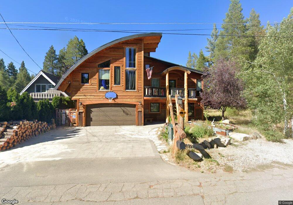
871 Michael Dr South Lake Tahoe, CA 96150
Estimated Value: $809,000 - $1,298,000
4
Beds
2
Baths
2,244
Sq Ft
$462/Sq Ft
Est. Value
About This Home
This home is located at 871 Michael Dr, South Lake Tahoe, CA 96150 and is currently estimated at $1,037,317, approximately $462 per square foot. 871 Michael Dr is a home located in El Dorado County with nearby schools including Tahoe Valley Elementary School, South Tahoe Middle School, and South Tahoe High School.
Ownership History
Date
Name
Owned For
Owner Type
Purchase Details
Closed on
Aug 2, 2021
Sold by
Miller Gantt W and Miller Jayme L
Bought by
Miller Gantt W and Miller Jayme L
Current Estimated Value
Home Financials for this Owner
Home Financials are based on the most recent Mortgage that was taken out on this home.
Original Mortgage
$318,000
Outstanding Balance
$241,986
Interest Rate
2.3%
Mortgage Type
New Conventional
Estimated Equity
$795,331
Purchase Details
Closed on
Oct 2, 2006
Sold by
Moultrie Dalton V and Moultrie Debby Jean
Bought by
Miller Gantt W and Miller Jayme L
Home Financials for this Owner
Home Financials are based on the most recent Mortgage that was taken out on this home.
Original Mortgage
$400,000
Interest Rate
6.44%
Mortgage Type
Purchase Money Mortgage
Create a Home Valuation Report for This Property
The Home Valuation Report is an in-depth analysis detailing your home's value as well as a comparison with similar homes in the area
Home Values in the Area
Average Home Value in this Area
Purchase History
| Date | Buyer | Sale Price | Title Company |
|---|---|---|---|
| Miller Gantt W | -- | Old Republic Title Company | |
| Miller Gantt W | $505,000 | Placer Title Company |
Source: Public Records
Mortgage History
| Date | Status | Borrower | Loan Amount |
|---|---|---|---|
| Open | Miller Gantt W | $318,000 | |
| Closed | Miller Gantt W | $400,000 |
Source: Public Records
Tax History Compared to Growth
Tax History
| Year | Tax Paid | Tax Assessment Tax Assessment Total Assessment is a certain percentage of the fair market value that is determined by local assessors to be the total taxable value of land and additions on the property. | Land | Improvement |
|---|---|---|---|---|
| 2025 | $8,701 | $813,000 | $151,000 | $662,000 |
| 2024 | $8,701 | $813,000 | $151,000 | $662,000 |
| 2023 | $8,718 | $813,000 | $151,000 | $662,000 |
| 2022 | $8,803 | $813,000 | $151,000 | $662,000 |
| 2021 | $8,838 | $813,000 | $151,000 | $662,000 |
| 2020 | $8,799 | $813,000 | $151,000 | $662,000 |
| 2019 | $5,996 | $543,000 | $151,000 | $392,000 |
| 2018 | $5,977 | $543,000 | $151,000 | $392,000 |
| 2017 | $5,999 | $543,000 | $151,000 | $392,000 |
| 2016 | $4,982 | $450,000 | $135,000 | $315,000 |
| 2015 | $4,712 | $433,000 | $65,000 | $368,000 |
| 2014 | $4,712 | $433,000 | $65,000 | $368,000 |
Source: Public Records
Map
Nearby Homes
- 803 Michael Dr
- 2337 Sky Meadows Ct
- 783 Michael Ct Unit Share B
- 783 Michael Ct
- 2293 Eloise Ave Unit D
- 2244 Texas Ave
- 1025 Winnemucca Ave
- 1040 Truckee Dr
- 914 Tahoe Island Dr
- 2484 Palmira Ave
- 941 Silver Dollar Ave
- 2948 Pinewood Dr
- 923 Sagewood Dr
- 555 Tahoe Keys Blvd Unit 13
- 1116 Lindberg Ave
- 497 Tahoe Keys Blvd Unit 20
- 2165 Jean Ave
- 489 Tahoe Keys Blvd Unit 55
- 489 Tahoe Keys Blvd Unit 47
- 489 Tahoe Keys Blvd Unit 68
- 865 Michael Dr
- 2360 Washington Ave
- 2349 Oregon Ave
- 885 Michael Dr
- 2342 Washington Ave
- 2352 Oregon Ave
- 2359 Washington Ave
- 2365 California Ave
- 2346 Oregon Ave
- 849 Michael Dr
- 2345 Oregon Ave
- 2338 Washington Ave
- 850 Michael Dr
- 2359 California Ave
- 845 Michael Dr
- 2339 Washington Ave
- 2337 Oregon Ave
- 2332 Washington Ave
- 2355 California Ave
- 2376 California Ave