Estimated Value: $269,000 - $295,000
3
Beds
1
Bath
1,010
Sq Ft
$276/Sq Ft
Est. Value
About This Home
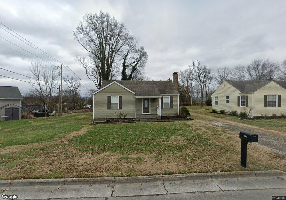
This home is located at 878 Long Rd, Alcoa, TN 37701 and is currently estimated at $278,916, approximately $276 per square foot. 878 Long Rd is a home located in Blount County with nearby schools including Alcoa Elementary School, Alcoa Middle School, and Alcoa High School.
Ownership History
Date
Name
Owned For
Owner Type
Purchase Details
Closed on
Oct 28, 2010
Sold by
Greene Wilda A
Bought by
Whitehorne Christopher
Current Estimated Value
Home Financials for this Owner
Home Financials are based on the most recent Mortgage that was taken out on this home.
Original Mortgage
$89,925
Outstanding Balance
$59,401
Interest Rate
4.37%
Estimated Equity
$219,515
Purchase Details
Closed on
Mar 31, 2009
Bought by
Greene Wilda A
Purchase Details
Closed on
May 10, 2006
Bought by
Blue Ribbon Homes Com Inc
Purchase Details
Closed on
May 1, 1991
Bought by
Monday Robert W
Purchase Details
Closed on
Sep 1, 1947
Bought by
Monday William Eugene
Create a Home Valuation Report for This Property
The Home Valuation Report is an in-depth analysis detailing your home's value as well as a comparison with similar homes in the area
Home Values in the Area
Average Home Value in this Area
Purchase History
| Date | Buyer | Sale Price | Title Company |
|---|---|---|---|
| Whitehorne Christopher | $119,900 | -- | |
| Greene Wilda A | $1,620,000 | -- | |
| Blue Ribbon Homes Com Inc | $2,036,100 | -- | |
| Monday Robert W | $350,000 | -- | |
| Monday William Eugene | -- | -- |
Source: Public Records
Mortgage History
| Date | Status | Borrower | Loan Amount |
|---|---|---|---|
| Open | Monday William Eugene | $89,925 |
Source: Public Records
Tax History
| Year | Tax Paid | Tax Assessment Tax Assessment Total Assessment is a certain percentage of the fair market value that is determined by local assessors to be the total taxable value of land and additions on the property. | Land | Improvement |
|---|---|---|---|---|
| 2025 | -- | $46,075 | $10,125 | $35,950 |
| 2024 | -- | $46,075 | $10,125 | $35,950 |
| 2023 | $1,512 | $46,075 | $10,125 | $35,950 |
| 2022 | $1,337 | $28,200 | $5,625 | $22,575 |
| 2021 | $1,337 | $28,200 | $5,625 | $22,575 |
| 2020 | $1,337 | $28,200 | $5,625 | $22,575 |
| 2019 | $1,337 | $28,200 | $5,625 | $22,575 |
| 2018 | $1,013 | $22,875 | $5,950 | $16,925 |
| 2017 | $1,013 | $22,875 | $5,950 | $16,925 |
| 2016 | $1,013 | $22,875 | $5,950 | $16,925 |
| 2015 | $940 | $22,875 | $5,950 | $16,925 |
| 2014 | $1,076 | $22,875 | $5,950 | $16,925 |
| 2013 | $1,076 | $26,175 | $0 | $0 |
Source: Public Records
Map
Nearby Homes
- 1741 N Wright Rd
- 1539 Boyle St
- 1450 Dalton St
- 1631 Springbrook Rd
- 1413 Perkins St
- 869 Cedar St
- 1119 Cherry St
- 1321 Nobel St Unit E
- 971 Maple St
- 1240 N Wright Rd
- 922 Poplar St
- 0 N Wright Rd
- 966 Poplar St
- 1826 Peppertree Dr
- 1538 Tsuga Dr
- 2620 Marshall St
- 2638 Orton Dr
- 3473 Russellwood Dr
- 646 Kirkwell Dr
- 2405 Huckleberry Dr
- 870 Long Rd
- 1841 Kettering Rd
- 1827 Kettering Rd
- 864 Long Rd
- 861 Burroughs Rd
- 855 Burroughs Rd
- 1823 Kettering Rd
- 849 Burroughs Rd
- 871 Burroughs Rd
- 858 Long Rd
- 1847 Kettering Rd
- 877 Long Rd
- 871 Long Rd
- 1817 Kettering Rd
- 843 Burroughs Rd
- 863 Long Rd
- 1836 Kettering Rd
- 1844 Kettering Rd
- 1814 Dalton St
- 1824 Kettering Rd
Your Personal Tour Guide
Ask me questions while you tour the home.