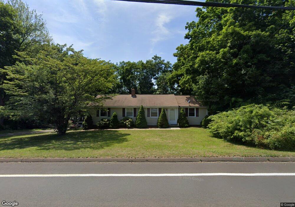
88 Branford Rd North Branford, CT 06471
Estimated Value: $372,000 - $470,000
3
Beds
1
Bath
1,352
Sq Ft
$302/Sq Ft
Est. Value
About This Home
This home is located at 88 Branford Rd, North Branford, CT 06471 and is currently estimated at $407,740, approximately $301 per square foot. 88 Branford Rd is a home located in New Haven County with nearby schools including Jerome Harrison School, Totoket Valley Elementary School, and North Branford Intermediate School.
Ownership History
Date
Name
Owned For
Owner Type
Purchase Details
Closed on
Dec 29, 2011
Sold by
Godfrey Stephen M
Bought by
Godfrey Cary A
Current Estimated Value
Purchase Details
Closed on
Nov 25, 1998
Sold by
Stewart Carol H and Mulvey Daniel
Bought by
Godfrey Stephen M and Godfrey Cary A
Home Financials for this Owner
Home Financials are based on the most recent Mortgage that was taken out on this home.
Original Mortgage
$119,250
Interest Rate
6.83%
Purchase Details
Closed on
Jul 16, 1998
Sold by
Royka John W and Royka Dorothy K
Bought by
Stewart Carol H and Mulvey Daniel
Home Financials for this Owner
Home Financials are based on the most recent Mortgage that was taken out on this home.
Original Mortgage
$57,000
Interest Rate
6.98%
Mortgage Type
Unknown
Create a Home Valuation Report for This Property
The Home Valuation Report is an in-depth analysis detailing your home's value as well as a comparison with similar homes in the area
Home Values in the Area
Average Home Value in this Area
Purchase History
| Date | Buyer | Sale Price | Title Company |
|---|---|---|---|
| Godfrey Cary A | -- | -- | |
| Godfrey Stephen M | $132,500 | -- | |
| Stewart Carol H | $87,000 | -- |
Source: Public Records
Mortgage History
| Date | Status | Borrower | Loan Amount |
|---|---|---|---|
| Previous Owner | Stewart Carol H | $118,000 | |
| Previous Owner | Stewart Carol H | $119,250 | |
| Previous Owner | Stewart Carol H | $57,000 |
Source: Public Records
Tax History Compared to Growth
Tax History
| Year | Tax Paid | Tax Assessment Tax Assessment Total Assessment is a certain percentage of the fair market value that is determined by local assessors to be the total taxable value of land and additions on the property. | Land | Improvement |
|---|---|---|---|---|
| 2025 | $6,414 | $232,300 | $98,400 | $133,900 |
| 2024 | $5,249 | $146,100 | $82,000 | $64,100 |
| 2023 | $5,043 | $146,100 | $82,000 | $64,100 |
| 2022 | $4,855 | $146,100 | $82,000 | $64,100 |
| 2021 | $4,842 | $146,100 | $82,000 | $64,100 |
| 2020 | $4,580 | $136,400 | $72,600 | $63,800 |
| 2019 | $4,564 | $136,400 | $72,600 | $63,800 |
| 2018 | $4,554 | $136,400 | $72,600 | $63,800 |
| 2017 | $4,571 | $136,400 | $72,600 | $63,800 |
| 2016 | $4,362 | $136,400 | $72,600 | $63,800 |
| 2015 | $4,236 | $136,300 | $72,600 | $63,700 |
| 2014 | $4,078 | $136,300 | $72,600 | $63,700 |
Source: Public Records
Map
Nearby Homes
- 223 Twin Lakes Rd Unit D
- 11 School Ground Rd Unit TRLR 10
- 18 Ridge Acres Rd
- 229 Branford Rd Unit 222
- 229 Branford Rd Unit 519
- 229 Branford Rd Unit 520
- 525 E Main St Unit 33
- 525 E Main St Unit 23
- 525 E Main St Unit 56
- 525 E Main St Unit 44
- 525 E Main St Unit 8
- 13 Pond View Terrace
- 10 Lea Rd
- 260 Notch Hill Rd
- 0 Gould Ln
- 63 Gould Ln
- 132 Linsley Lake Rd
- 72 Notch Hill Rd
- 12 Rivaldi Dr
- 43 North St
- 84 Branford Rd
- 73 Branford Rd
- 96 Branford Rd
- 80 Branford Rd
- 102 Branford Rd
- 76 Branford Rd
- 81 Branford Rd
- 79 Branford Rd
- 70 Branford Rd
- 106 Branford Rd
- 77 Branford Rd
- 89 Branford Rd
- 66 Branford Rd
- 85 Branford Rd
- 4 Hubbard Rd
- 5 Enterprise Dr Unit 2
- 5 Enterprise Dr Unit 3
- 5 Enterprise Dr
- 93 Branford Rd
- 14 Hubbard Rd