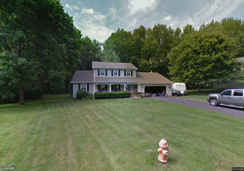
880 Ewing Rd Youngstown, OH 44512
Estimated Value: $302,000 - $333,000
3
Beds
3
Baths
2,488
Sq Ft
$128/Sq Ft
Est. Value
About This Home
This home is located at 880 Ewing Rd, Youngstown, OH 44512 and is currently estimated at $317,885, approximately $127 per square foot. 880 Ewing Rd is a home located in Mahoning County with nearby schools including West Boulevard Elementary School, Boardman Center Middle School, and Boardman High School.
Ownership History
Date
Name
Owned For
Owner Type
Purchase Details
Closed on
Oct 13, 2022
Sold by
Davis Elizabeth J and Gillam Elizabeth J
Bought by
Gillam Russell W and Gillam Robert Christopher
Current Estimated Value
Purchase Details
Closed on
Nov 1, 1984
Bought by
Gillam Elizabeth J
Create a Home Valuation Report for This Property
The Home Valuation Report is an in-depth analysis detailing your home's value as well as a comparison with similar homes in the area
Home Values in the Area
Average Home Value in this Area
Purchase History
| Date | Buyer | Sale Price | Title Company |
|---|---|---|---|
| Gillam Russell W | -- | -- | |
| Gillam Elizabeth J | -- | -- |
Source: Public Records
Tax History Compared to Growth
Tax History
| Year | Tax Paid | Tax Assessment Tax Assessment Total Assessment is a certain percentage of the fair market value that is determined by local assessors to be the total taxable value of land and additions on the property. | Land | Improvement |
|---|---|---|---|---|
| 2024 | $3,908 | $87,200 | $11,720 | $75,480 |
| 2023 | $3,887 | $87,200 | $11,720 | $75,480 |
| 2022 | $3,794 | $67,030 | $11,120 | $55,910 |
| 2021 | $3,796 | $67,030 | $11,120 | $55,910 |
| 2020 | $3,816 | $67,030 | $11,120 | $55,910 |
| 2019 | $3,619 | $58,290 | $9,670 | $48,620 |
| 2018 | $3,138 | $58,290 | $9,670 | $48,620 |
| 2017 | $3,001 | $58,290 | $9,670 | $48,620 |
| 2016 | $2,867 | $53,610 | $10,700 | $42,910 |
| 2015 | $2,810 | $53,610 | $10,700 | $42,910 |
| 2014 | $2,818 | $53,610 | $10,700 | $42,910 |
| 2013 | $2,782 | $53,610 | $10,700 | $42,910 |
Source: Public Records
Map
Nearby Homes
- 6632 Harrington Ave
- 813 Brookfield Ave
- 772 Ewing Rd
- 768 Crestview Dr
- 6938 Ron Park Place
- 0 Pinewood Dr Unit 5140025
- 715 Crestview Dr
- 396 Brookfield Ave
- 6723 Lockwood Blvd Unit 4
- 6747 Lockwood Blvd
- 6743 Lockwood Blvd
- 1422 Turnberry Dr
- 5670 Tracy Dr
- 6931 Lockwood Blvd
- 6892 Glenwood Ave
- 272 Ewing Rd
- 1193 Red Tail Hawk Ct Unit 1
- 990 Westport Dr
- 242 Oakley Ave
- 5200 West Blvd Unit 505
- 874 Ewing Rd
- 886 Ewing Rd
- 868 Ewing Rd
- 6450 Mill Creek Blvd
- 6456 Mill Creek Blvd
- 845 Wildwood Dr
- 835 Wildwood Dr
- 829 Wildwood Dr
- 862 Ewing Rd
- 823 Wildwood Dr
- 6464 Mill Creek Blvd
- 817 Wildwood Dr
- 6445 Mill Creek Blvd
- 6449 Mill Creek Blvd
- 6480 Mill Creek Blvd
- 6453 Mill Creek Blvd
- 811 Wildwood Dr
- 860 Brookfield Ave
- 6584 Mill Creek Blvd
- 855 Ewing Rd