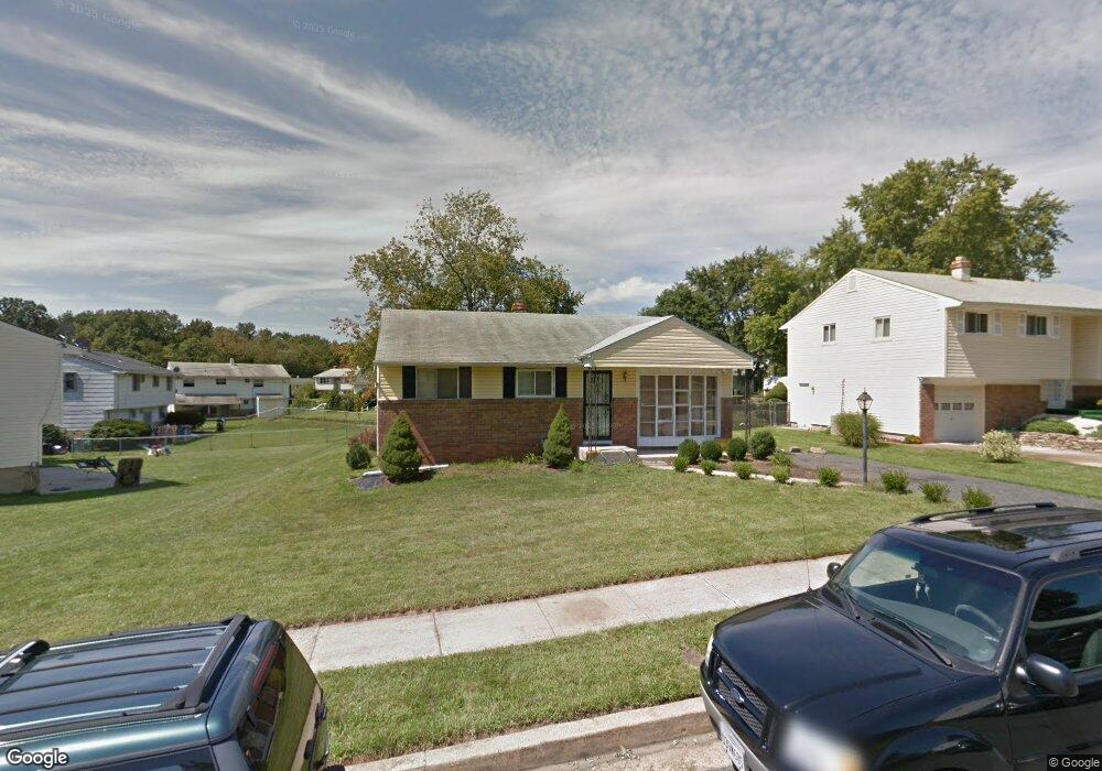
8803 Sigrid Rd Randallstown, MD 21133
Estimated Value: $320,000 - $344,000
--
Bed
2
Baths
1,044
Sq Ft
$313/Sq Ft
Est. Value
About This Home
This home is located at 8803 Sigrid Rd, Randallstown, MD 21133 and is currently estimated at $327,251, approximately $313 per square foot. 8803 Sigrid Rd is a home located in Baltimore County with nearby schools including Church Lane Elementary Technology School, Northwest Academy of Health Sciences, and Randallstown High School.
Ownership History
Date
Name
Owned For
Owner Type
Purchase Details
Closed on
Aug 23, 1999
Sold by
Secretary Of Veterans Affairs
Bought by
Cuffey Talita
Current Estimated Value
Purchase Details
Closed on
Mar 25, 1999
Sold by
Matthews Troy Percell
Bought by
Secretary Of Veterans Affairs
Purchase Details
Closed on
Oct 10, 1997
Sold by
Lang Eric Of The
Bought by
Matthews Troy Percell and Matthews Toddlena P
Purchase Details
Closed on
Jan 13, 1997
Sold by
Lang Arthur
Bought by
Lang Eric Of The
Create a Home Valuation Report for This Property
The Home Valuation Report is an in-depth analysis detailing your home's value as well as a comparison with similar homes in the area
Home Values in the Area
Average Home Value in this Area
Purchase History
| Date | Buyer | Sale Price | Title Company |
|---|---|---|---|
| Cuffey Talita | $65,000 | -- | |
| Secretary Of Veterans Affairs | $87,547 | -- | |
| Matthews Troy Percell | $98,900 | -- | |
| Lang Eric Of The | -- | -- |
Source: Public Records
Tax History Compared to Growth
Tax History
| Year | Tax Paid | Tax Assessment Tax Assessment Total Assessment is a certain percentage of the fair market value that is determined by local assessors to be the total taxable value of land and additions on the property. | Land | Improvement |
|---|---|---|---|---|
| 2025 | $3,886 | $254,100 | -- | -- |
| 2024 | $3,886 | $236,700 | $73,800 | $162,900 |
| 2023 | $1,935 | $219,333 | $0 | $0 |
| 2022 | $3,489 | $201,967 | $0 | $0 |
| 2021 | $2,975 | $184,600 | $55,800 | $128,800 |
| 2020 | $2,975 | $176,900 | $0 | $0 |
| 2019 | $2,825 | $169,200 | $0 | $0 |
| 2018 | $2,626 | $161,500 | $55,800 | $105,700 |
| 2017 | $2,586 | $153,267 | $0 | $0 |
| 2016 | $2,283 | $145,033 | $0 | $0 |
| 2015 | $2,283 | $136,800 | $0 | $0 |
| 2014 | $2,283 | $136,800 | $0 | $0 |
Source: Public Records
Map
Nearby Homes
- 8541 Lucerne Rd
- 4001 Starbrook Rd
- 3921 Zurich Rd
- 3907 Roxanne Rd
- 8908 Meadow Heights Rd
- 8802 Falcon Ridge Dr
- 3821 Brownhill Rd
- 8513 Charlton Rd
- 4108 Century Towne Rd
- 4105 Kiwi Ct
- 9012 Allenswood Rd
- 3705 Allenswood Ct
- 8806 Gilly Way Unit D
- 9044 Allenswood Rd
- 4210 Mary Ridge Dr
- 4818 Oakland Park Rd
- 4817 Valley Forge Rd
- 4816 Valley Forge Rd
- 4812 Valley Forge Rd
- 3854 Terka Cir
- 8805 Sigrid Rd
- 8734 Meadow Heights Rd
- 8736 Meadow Heights Rd
- 8807 Sigrid Rd
- 3905 Sadie Rd
- 3903 Sadie Rd
- 8802 Sigrid Rd
- 3901 Sadie Rd
- 8800 Sigrid Rd
- 8804 Sigrid Rd
- 8809 Sigrid Rd
- 3907 Sadie Rd
- 8806 Sigrid Rd
- 8731 Meadow Heights Rd
- 8735 Meadow Heights Rd
- 8733 Meadow Heights Rd
- 8811 Sigrid Rd
- 8729 Meadow Heights Rd
- 3909 Sadie Rd
- 8737 Meadow Heights Rd