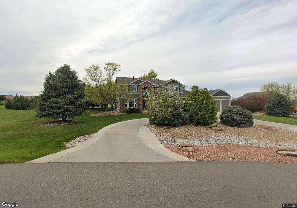
8816 Longs Peak Cir Windsor, CO 80550
Estimated Value: $1,125,918 - $1,295,000
5
Beds
3
Baths
2,876
Sq Ft
$421/Sq Ft
Est. Value
About This Home
This home is located at 8816 Longs Peak Cir, Windsor, CO 80550 and is currently estimated at $1,209,480, approximately $420 per square foot. 8816 Longs Peak Cir is a home located in Larimer County with nearby schools including High Plains School, Mountain View High School, and Colorado Early Colleges Windsor.
Ownership History
Date
Name
Owned For
Owner Type
Purchase Details
Closed on
Oct 13, 2011
Sold by
Clark Donna R and Clark Michael A
Bought by
Hay Bill D and Hay Rachael T
Current Estimated Value
Home Financials for this Owner
Home Financials are based on the most recent Mortgage that was taken out on this home.
Original Mortgage
$417,000
Outstanding Balance
$286,867
Interest Rate
4.28%
Mortgage Type
New Conventional
Estimated Equity
$922,613
Purchase Details
Closed on
Dec 9, 2003
Sold by
Us Home Corp
Bought by
Clark Donna R and Clark Michael A
Home Financials for this Owner
Home Financials are based on the most recent Mortgage that was taken out on this home.
Original Mortgage
$333,700
Interest Rate
5.94%
Mortgage Type
Purchase Money Mortgage
Create a Home Valuation Report for This Property
The Home Valuation Report is an in-depth analysis detailing your home's value as well as a comparison with similar homes in the area
Home Values in the Area
Average Home Value in this Area
Purchase History
| Date | Buyer | Sale Price | Title Company |
|---|---|---|---|
| Hay Bill D | $475,000 | Heritage Title | |
| Clark Donna R | $435,481 | North American Title |
Source: Public Records
Mortgage History
| Date | Status | Borrower | Loan Amount |
|---|---|---|---|
| Open | Hay Bill D | $417,000 | |
| Previous Owner | Clark Donna R | $333,700 | |
| Closed | Clark Donna R | $99,700 |
Source: Public Records
Tax History Compared to Growth
Tax History
| Year | Tax Paid | Tax Assessment Tax Assessment Total Assessment is a certain percentage of the fair market value that is determined by local assessors to be the total taxable value of land and additions on the property. | Land | Improvement |
|---|---|---|---|---|
| 2025 | $6,148 | $70,598 | $27,470 | $43,128 |
| 2024 | $5,955 | $70,598 | $27,470 | $43,128 |
| 2022 | $4,503 | $49,061 | $17,723 | $31,338 |
| 2021 | $4,615 | $50,472 | $18,233 | $32,239 |
| 2020 | $4,258 | $46,518 | $15,158 | $31,360 |
| 2019 | $3,894 | $43,172 | $15,158 | $28,014 |
| 2018 | $3,647 | $38,866 | $11,232 | $27,634 |
| 2017 | $3,208 | $38,866 | $11,232 | $27,634 |
| 2016 | $3,479 | $40,915 | $10,030 | $30,885 |
| 2015 | $3,435 | $40,910 | $10,030 | $30,880 |
| 2014 | $2,788 | $32,040 | $7,120 | $24,920 |
Source: Public Records
Map
Nearby Homes
- 7407 Pimlico Dr
- 4605 Freehold Dr
- 4609 Freehold Dr
- 7401 Pimlico Dr
- 7401 Turnbull Ct
- 4511 Haystack Dr
- 5504 Fairmount Dr
- 8881 Longs Peak Cir
- 5830 Last Pointe Dr
- 7845 Blackwood Dr
- 8181 Wynstone Dr
- 5849 Crooked Stick Dr
- 5954 Black Lion Ct
- Plan C417 - 60 at Sugar Hills at RainDance - RainDance 60'
- Plan C505 - 60 at Festival at RainDance - RainDance 60'
- Plan C502 - 60 at Festival at RainDance - RainDance 60'
- Plan C502 - 60 at RainDance - 60'
- Plan C417 - 60 at Festival at RainDance - RainDance 60'
- Plan C555 - National 60s/70s at Sugar Hills at RainDance - RainDance National 60s/70s
- Plan C416 - 60 at Sugar Hills at RainDance - RainDance 60'
- 8814 Longs Peak Cir
- 8818 Longs Peak Cir
- 8817 Longs Peak Cir
- 8815 Longs Peak Cir
- 8813 Longs Peak Cir
- 4600 Horizon Ridge Dr
- 4604 Horizon Ridge Dr
- 4606 Horizon Ridge Dr
- 7423 Pimlico Dr
- 8800 Longs Peak Cir
- 8819 Longs Peak Cir
- 4608 Horizon Ridge Dr
- 8820 Longs Peak Cir
- 7441 Pimlico Dr
- 7465 Pimlico Dr
- 7487 Pimlico Dr
- 7493 Pimlico Dr
- 7527 Pimlico Dr
- 7541 Pimlico Dr
- 4610 Horizon Ridge Dr