S
Seller's Agent in 2025
Sara Ruzicka
Compass
(818) 462-5799
1 in this area
6 Total Sales
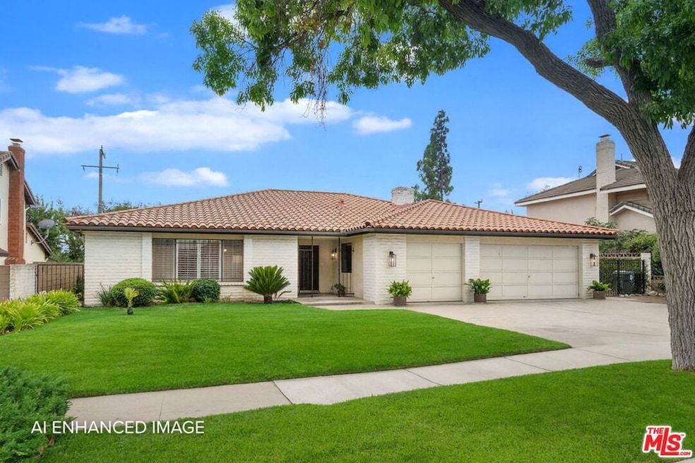
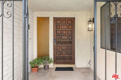
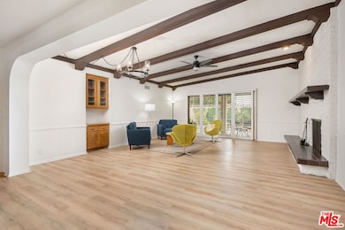
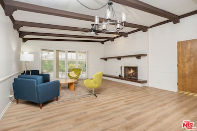
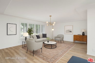
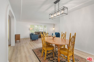
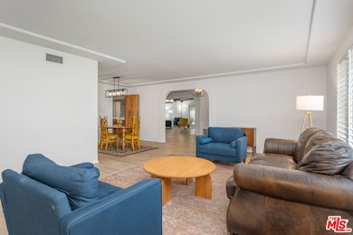
Discover the perfect blend of character, comfort, and function in this expansive 2,619 sq. ft. home. From the moment you arrive, the stunning mountain views and welcoming curb appeal set the tone. As you step inside, you'll be greeted by arched entryways and a thoughtful layout offering a partially open floor plan with excellent flow, ideal for both everyday living and entertaining. A timeless kitchen showcases modern appliances, an eat in breakfast bar and solid oak cabinetry providing ample storage. Glide from the kitchen into the formal dining room and spacious sitting room where oversized windows and plantation shutters effortlessly bathe the space with natural light. The primary suite is a true retreat, complete with a large walk-in closet, duel sinks and designated dressing area. The additional bedrooms are equally inviting, offering versatility for family, guests, or a private home office, each paired with easy access to the home's three full bathrooms. The heart of the home is the cozy living room, where the rustic solid beam ceiling and original fireplace create warmth and ambiance, a perfect setting for relaxing evenings. Step through the large sliding glass doors onto the expansive patio ideal for outdoor dining, enjoying a morning cup of coffee or entertaining guests. A verdant, fenced in yard awaits, surrounded by privacy landscaping where you can enjoy the lush grass or allow the expanse to become your canvas for the oasis of your dreams. Additional home features include a spacious 3 car garage, central vacuum system and gated front door. This stunning property blends comfort and functionality in one of the most sought after areas of Upland, a tranquil suburban escape waiting for you to come make it yours.
| Date | Type | Sale Price | Title Company |
|---|---|---|---|
| Grant Deed | $1,050,000 | Consumers Title | |
| Grant Deed | -- | None Listed On Document | |
| Grant Deed | $38,000 | First American | |
| Trustee Deed | $68,745 | Fidelity National Title Ins | |
| Grant Deed | -- | First American Title Ins Co |
| Date | Status | Loan Amount | Loan Type |
|---|---|---|---|
| Open | $650,000 | New Conventional |
| Date | Event | Price | List to Sale | Price per Sq Ft |
|---|---|---|---|---|
| 12/27/2025 12/27/25 | Sold | $1,050,000 | +5.0% | $401 / Sq Ft |
| 11/14/2025 11/14/25 | Pending | -- | -- | -- |
| 10/08/2025 10/08/25 | Price Changed | $1,000,000 | -13.0% | $382 / Sq Ft |
| 09/09/2025 09/09/25 | For Sale | $1,150,000 | -- | $439 / Sq Ft |
| Year | Tax Paid | Tax Assessment Tax Assessment Total Assessment is a certain percentage of the fair market value that is determined by local assessors to be the total taxable value of land and additions on the property. | Land | Improvement |
|---|---|---|---|---|
| 2025 | $2,356 | $200,303 | $20,291 | $180,012 |
| 2024 | $2,281 | $196,375 | $19,893 | $176,482 |
| 2023 | $2,246 | $192,525 | $19,503 | $173,022 |
| 2022 | $2,122 | $188,748 | $19,122 | $169,626 |
| 2021 | $2,115 | $185,047 | $18,747 | $166,300 |
| 2020 | $2,057 | $183,150 | $18,555 | $164,595 |
| 2019 | $2,049 | $179,559 | $18,191 | $161,368 |
| 2018 | $2,000 | $176,038 | $17,834 | $158,204 |
| 2017 | $1,941 | $172,586 | $17,484 | $155,102 |
| 2016 | $1,758 | $169,202 | $17,141 | $152,061 |
| 2015 | $1,717 | $166,661 | $16,884 | $149,777 |
| 2014 | $1,672 | $163,396 | $16,553 | $146,843 |
S
Seller's Agent in 2025
Sara Ruzicka
Compass
(818) 462-5799
1 in this area
6 Total Sales
C
Seller Co-Listing Agent in 2025
Courtney Van Cott
Compass
(480) 399-7048
1 in this area
53 Total Sales

Buyer's Agent in 2025
Miguel Galaviz
Coldwell Banker Envision
(909) 549-6647
1 in this area
24 Total Sales
Source: The MLS
MLS Number: 25589923
APN: 1044-601-02
Disclaimer: Certain information contained herein is derived from information provided by parties other than Homes.com. All information provided is deemed reliable, but is not guaranteed to be accurate and should be independently verified.
![]() © 2026 The MLS™ - Combined L.A. Westside MLS (CLAW). All rights reserved. Based on information from The MLS™ - Combined L.A. Westside MLS (CLAW). All data, including all measurements and calculations of area, is obtained from various sources and has not been, and will not be, verified by broker or MLS. All information should be independently reviewed and verified for accuracy. Properties may or may not be listed by the office/agent presenting the information.
© 2026 The MLS™ - Combined L.A. Westside MLS (CLAW). All rights reserved. Based on information from The MLS™ - Combined L.A. Westside MLS (CLAW). All data, including all measurements and calculations of area, is obtained from various sources and has not been, and will not be, verified by broker or MLS. All information should be independently reviewed and verified for accuracy. Properties may or may not be listed by the office/agent presenting the information.
IDX information is provided exclusively for personal, non-commercial use, and may not be used for any purpose other than to identify prospective properties consumers may be interested in purchasing.
Information is deemed reliable but not guaranteed.
Ask me questions while you tour the home.