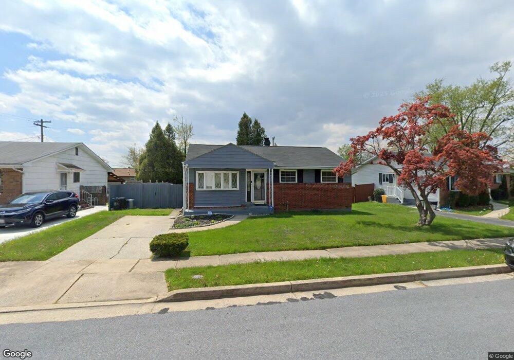
8833 Sigrid Rd Randallstown, MD 21133
Estimated Value: $254,826 - $356,000
--
Bed
1
Bath
1,044
Sq Ft
$292/Sq Ft
Est. Value
About This Home
This home is located at 8833 Sigrid Rd, Randallstown, MD 21133 and is currently estimated at $305,207, approximately $292 per square foot. 8833 Sigrid Rd is a home located in Baltimore County with nearby schools including Church Lane Elementary Technology School, Northwest Academy of Health Sciences, and Randallstown High School.
Ownership History
Date
Name
Owned For
Owner Type
Purchase Details
Closed on
Mar 19, 2012
Sold by
Sharp Charles H
Bought by
Sharp Nefertiri
Current Estimated Value
Purchase Details
Closed on
Nov 16, 1994
Sold by
Boose Leila M
Bought by
Sharp Charles H
Home Financials for this Owner
Home Financials are based on the most recent Mortgage that was taken out on this home.
Original Mortgage
$91,411
Interest Rate
8.9%
Create a Home Valuation Report for This Property
The Home Valuation Report is an in-depth analysis detailing your home's value as well as a comparison with similar homes in the area
Home Values in the Area
Average Home Value in this Area
Purchase History
| Date | Buyer | Sale Price | Title Company |
|---|---|---|---|
| Sharp Nefertiri | -- | None Available | |
| Sharp Charles H | $91,500 | -- |
Source: Public Records
Mortgage History
| Date | Status | Borrower | Loan Amount |
|---|---|---|---|
| Closed | Sharp Charles H | $91,411 |
Source: Public Records
Tax History Compared to Growth
Tax History
| Year | Tax Paid | Tax Assessment Tax Assessment Total Assessment is a certain percentage of the fair market value that is determined by local assessors to be the total taxable value of land and additions on the property. | Land | Improvement |
|---|---|---|---|---|
| 2025 | $2,802 | $240,133 | -- | -- |
| 2024 | $2,802 | $223,600 | $73,200 | $150,400 |
| 2023 | $1,381 | $207,100 | $0 | $0 |
| 2022 | $2,682 | $190,600 | $0 | $0 |
| 2021 | $2,817 | $174,100 | $55,200 | $118,900 |
| 2020 | $2,817 | $167,067 | $0 | $0 |
| 2019 | $2,543 | $160,033 | $0 | $0 |
| 2018 | $2,370 | $153,000 | $55,200 | $97,800 |
| 2017 | $2,184 | $145,367 | $0 | $0 |
| 2016 | $1,926 | $137,733 | $0 | $0 |
| 2015 | $1,926 | $130,100 | $0 | $0 |
| 2014 | $1,926 | $130,100 | $0 | $0 |
Source: Public Records
Map
Nearby Homes
- 3907 Roxanne Rd
- 8908 Meadow Heights Rd
- 4001 Starbrook Rd
- 8802 Falcon Ridge Dr
- 8541 Lucerne Rd
- 3921 Zurich Rd
- 4105 Kiwi Ct
- 8806 Gilly Way Unit D
- 9044 Allenswood Rd
- 4108 Century Towne Rd
- 9012 Allenswood Rd
- 3854 Terka Cir
- 3705 Allenswood Ct
- 4210 Mary Ridge Dr
- 20 Windy Meadow Ct
- 3805 Terka Cir
- 3821 Brownhill Rd
- 20 Sunrise Ct
- 28 Sunrise Ct
- 8513 Charlton Rd