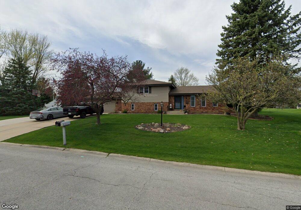
8834 Mathews St Crown Point, IN 46307
Estimated Value: $322,000 - $354,000
4
Beds
2
Baths
1,994
Sq Ft
$170/Sq Ft
Est. Value
About This Home
This home is located at 8834 Mathews St, Crown Point, IN 46307 and is currently estimated at $339,787, approximately $170 per square foot. 8834 Mathews St is a home located in Lake County with nearby schools including Hal E Clark Middle School, Peifer Elementary School, and Lake Central High School.
Ownership History
Date
Name
Owned For
Owner Type
Purchase Details
Closed on
Apr 12, 2018
Sold by
Olson David S
Bought by
Olson David S and Olson Lori A
Current Estimated Value
Home Financials for this Owner
Home Financials are based on the most recent Mortgage that was taken out on this home.
Original Mortgage
$177,600
Interest Rate
4.46%
Mortgage Type
New Conventional
Create a Home Valuation Report for This Property
The Home Valuation Report is an in-depth analysis detailing your home's value as well as a comparison with similar homes in the area
Home Values in the Area
Average Home Value in this Area
Purchase History
| Date | Buyer | Sale Price | Title Company |
|---|---|---|---|
| Olson David S | -- | Fidelity National Title Co |
Source: Public Records
Mortgage History
| Date | Status | Borrower | Loan Amount |
|---|---|---|---|
| Closed | Olson David S | $177,600 |
Source: Public Records
Tax History
| Year | Tax Paid | Tax Assessment Tax Assessment Total Assessment is a certain percentage of the fair market value that is determined by local assessors to be the total taxable value of land and additions on the property. | Land | Improvement |
|---|---|---|---|---|
| 2025 | $2,665 | $323,300 | $75,300 | $248,000 |
| 2024 | $5,940 | $308,500 | $75,300 | $233,200 |
| 2023 | $2,680 | $291,700 | $75,300 | $216,400 |
| 2022 | $2,680 | $266,200 | $75,300 | $190,900 |
| 2021 | $2,544 | $258,000 | $75,300 | $182,700 |
| 2020 | $2,531 | $251,200 | $75,300 | $175,900 |
| 2019 | $2,425 | $223,700 | $55,300 | $168,400 |
| 2018 | $2,281 | $214,200 | $55,300 | $158,900 |
| 2017 | $2,143 | $212,500 | $55,300 | $157,200 |
| 2016 | $2,005 | $201,000 | $55,300 | $145,700 |
| 2014 | $2,002 | $210,600 | $55,800 | $154,800 |
| 2013 | $1,983 | $205,500 | $55,800 | $149,700 |
Source: Public Records
Map
Nearby Homes
- 8748 Durbin Ln
- 8845 Clark Place
- 9017 Mathews St
- 8777 Burr Ridge Cir
- 5012 W 92nd Ave
- 5980 Wexford Way
- 6076 Wexford Way
- 9082 Dallas Place
- 9204 Wright St
- 6440 W 89th Ave
- 6308 W 91st Ave
- 2952 Freedom Cir
- 5547 Victoria Place
- 10406 Whitney Place
- 10444 Whitney Place
- 10474 Whitney Place
- 10467 Whitney Place
- 10475 Whitney Place
- 8109 Victoria Place
- 10920 Missouri Place
- 8808 Mathews St
- 5250 Hanley Ln
- 5210 Hanley Ln
- 8829 Durbin Ct
- 8772 Durbin Ln
- 8835 Mathews St
- 5290 Hanley Ln
- 8821 Mathews St
- 8807 Mathews St
- 8849 Mathews St
- 8839 Durbin Ct
- 5310 Hanley Ln
- 8863 Mathews St
- 5143 W 87th Ln
- 8760 Durbin Ln
- 8768 Mathews St
- 5117 W 87th Ln
- 8759 Mathews St
- 8819 Durbin Ct
- 5209 Hanley Ln
Your Personal Tour Guide
Ask me questions while you tour the home.