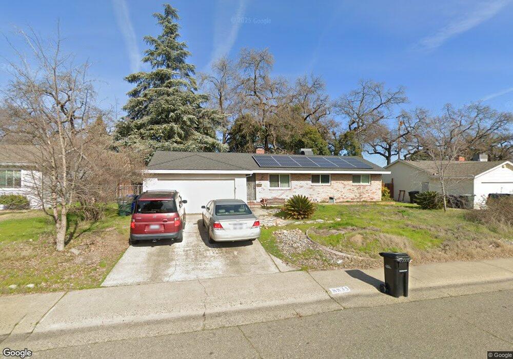
8835 Pershing Ave Orangevale, CA 95662
Estimated Value: $430,905 - $516,000
3
Beds
2
Baths
1,008
Sq Ft
$458/Sq Ft
Est. Value
About This Home
This home is located at 8835 Pershing Ave, Orangevale, CA 95662 and is currently estimated at $461,726, approximately $458 per square foot. 8835 Pershing Ave is a home located in Sacramento County with nearby schools including Pershing Elementary School, Andrew Carnegie Middle School, and Bella Vista High School.
Ownership History
Date
Name
Owned For
Owner Type
Purchase Details
Closed on
May 20, 2009
Sold by
Smith Michael Brooks and Estate Of Irene J Smith
Bought by
Regan Debra Sue
Current Estimated Value
Home Financials for this Owner
Home Financials are based on the most recent Mortgage that was taken out on this home.
Original Mortgage
$186,558
Outstanding Balance
$117,554
Interest Rate
4.8%
Mortgage Type
FHA
Estimated Equity
$344,172
Create a Home Valuation Report for This Property
The Home Valuation Report is an in-depth analysis detailing your home's value as well as a comparison with similar homes in the area
Home Values in the Area
Average Home Value in this Area
Purchase History
| Date | Buyer | Sale Price | Title Company |
|---|---|---|---|
| Regan Debra Sue | $190,000 | Chicago Title Company |
Source: Public Records
Mortgage History
| Date | Status | Borrower | Loan Amount |
|---|---|---|---|
| Open | Regan Debra Sue | $186,558 |
Source: Public Records
Tax History
| Year | Tax Paid | Tax Assessment Tax Assessment Total Assessment is a certain percentage of the fair market value that is determined by local assessors to be the total taxable value of land and additions on the property. | Land | Improvement |
|---|---|---|---|---|
| 2025 | $2,848 | $244,658 | $115,891 | $128,767 |
| 2024 | $2,848 | $239,862 | $113,619 | $126,243 |
| 2023 | $2,776 | $235,160 | $111,392 | $123,768 |
| 2022 | $2,760 | $230,550 | $109,208 | $121,342 |
| 2021 | $2,713 | $226,030 | $107,067 | $118,963 |
| 2020 | $2,663 | $223,714 | $105,970 | $117,744 |
| 2019 | $2,608 | $219,329 | $103,893 | $115,436 |
| 2018 | $2,577 | $215,029 | $101,856 | $113,173 |
| 2017 | $2,551 | $210,813 | $99,859 | $110,954 |
| 2016 | $2,384 | $206,680 | $97,901 | $108,779 |
| 2015 | $2,343 | $203,577 | $96,431 | $107,146 |
| 2014 | $2,293 | $199,591 | $94,543 | $105,048 |
Source: Public Records
Map
Nearby Homes
- 5817 Husker St
- 5630 Boltres St
- 8914 Aksarben Dr
- 8832 Canarsie Ave
- 8758 Corinne Dr
- 8805 Jonnie Way
- 6024 Mcneely Way
- 8754 Mellowdawn Way
- 8752 Mellowdawn Way
- 8859 Mohawk Way
- 8770 Greenback Ln
- 8814 Mohawk Way
- 8643 Monica Ave
- 5564 Fetz Ln
- 8626 Pershing Ave
- 5556 Fetz Ln
- 5540 Fetz Ln
- 5548 Fetz Ln
- 5596 Fetz Ln
- 8856 Venikov Place
- 8839 Pershing Ave
- 8831 Pershing Ave
- 8850 Nimbus Way
- 8843 Pershing Ave
- 8840 Nimbus Way
- 8825 Pershing Ave
- 8854 Nimbus Way
- 8836 Pershing Ave
- 8832 Pershing Ave
- 8830 Nimbus Way
- 8858 Nimbus Way
- 8828 Pershing Ave
- 8847 Pershing Ave
- 8844 Pershing Ave
- 8824 Pershing Ave
- 5709 Boltres St
- 8862 Nimbus Way
- 8820 Nimbus Way
- 8821 Pershing Ave
- 8851 Pershing Ave
Your Personal Tour Guide
Ask me questions while you tour the home.