


885 Alpine Rd Marion, IA 52302
Estimated payment $1,637/month
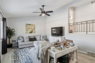
Highlights
- Vaulted Ceiling
- Great Room
- Patio
- Oak Ridge School Rated A-
- Eat-In Kitchen
- 5-minute walk to Donnelly Park
About This Home
Discover refined living in this beautifully updated 3-bedroom, 2.1-bath home, perfectly situated in one of Marion’s most sought-after neighborhoods. Thoughtful, high-quality updates span the interior, including new flooring throughout, elegantly remodeled bathrooms, and fresh designer paint. The kitchen has been tastefully refreshed, offering a clean, elevated aesthetic ideal for both everyday living and entertaining. Enjoy the comfort of a heated 2-car garage and the privacy of a fully fenced yard. A truly exceptional property that blends modern style with timeless comfort.
Home Details
Home Type
- Single Family
Est. Annual Taxes
- $3,852
Year Built
- Built in 1967
Lot Details
- 9,017 Sq Ft Lot
- Fenced
Parking
- 2 Car Garage
Home Design
- Split Level Home
- Poured Concrete
- Frame Construction
- Wood Siding
Interior Spaces
- Multi-Level Property
- Vaulted Ceiling
- Great Room
- Family Room
- Partial Basement
- Home Security System
Kitchen
- Eat-In Kitchen
- Range
- Microwave
- Dishwasher
- Disposal
Bedrooms and Bathrooms
- 3 Bedrooms
- Primary Bedroom Upstairs
Laundry
- Dryer
- Washer
Outdoor Features
- Patio
Schools
- Bowman Woods Elementary School
- Oak Ridge Middle School
- Linn Mar High School
Utilities
- Forced Air Heating and Cooling System
- Heating System Uses Gas
- Gas Water Heater
- Satellite Dish
Listing and Financial Details
- Assessor Parcel Number 113548400100000
Map
Home Values in the Area
Average Home Value in this Area
Tax History
| Year | Tax Paid | Tax Assessment Tax Assessment Total Assessment is a certain percentage of the fair market value that is determined by local assessors to be the total taxable value of land and additions on the property. | Land | Improvement |
|---|---|---|---|---|
| 2025 | $3,424 | $230,400 | $23,300 | $207,100 |
| 2024 | $3,240 | $199,600 | $23,300 | $176,300 |
| 2023 | $3,240 | $199,600 | $23,300 | $176,300 |
| 2022 | $3,086 | $154,900 | $23,300 | $131,600 |
| 2021 | $3,172 | $154,900 | $23,300 | $131,600 |
| 2020 | $3,172 | $140,800 | $23,300 | $117,500 |
| 2019 | $2,934 | $130,100 | $23,300 | $106,800 |
| 2018 | $2,632 | $130,100 | $23,300 | $106,800 |
| 2017 | $2,572 | $124,300 | $23,300 | $101,000 |
| 2016 | $2,682 | $124,300 | $23,300 | $101,000 |
| 2015 | $2,695 | $124,300 | $23,300 | $101,000 |
| 2014 | $2,486 | $124,300 | $23,300 | $101,000 |
| 2013 | $2,370 | $124,300 | $23,300 | $101,000 |
Property History
| Date | Event | Price | List to Sale | Price per Sq Ft |
|---|---|---|---|---|
| 12/03/2025 12/03/25 | For Sale | $250,000 | -- | $167 / Sq Ft |
Purchase History
| Date | Type | Sale Price | Title Company |
|---|---|---|---|
| Warranty Deed | $230,000 | None Listed On Document | |
| Interfamily Deed Transfer | -- | None Available |
Mortgage History
| Date | Status | Loan Amount | Loan Type |
|---|---|---|---|
| Open | $210,000 | New Conventional |
Source: Cedar Rapids Area Association of REALTORS®
MLS Number: 2509640
APN: 11354-84001-00000
Disclaimer: Certain information contained herein is derived from information provided by parties other than Homes.com. All information provided is deemed reliable, but is not guaranteed to be accurate and should be independently verified.
![]() IDX information is provided exclusively for personal, non-commercial use, and may not be used for any purpose other than to identify prospective properties consumers may be interested in purchasing.
IDX information is provided exclusively for personal, non-commercial use, and may not be used for any purpose other than to identify prospective properties consumers may be interested in purchasing.
Information is deemed reliable but not guaranteed.
- 915 W 10th Ave
- 1125 W 10th Ave
- 1310 Linnview Dr
- 823 Flight Dr
- 1074 Archer Dr
- 840 Longbow Ct
- 1080 Everdeen Ct
- 1089 Archer Dr
- 1110 Longview Dr
- 1013 Blairs Ferry R
- 2010 Newcastle Rd
- 1930 Bowstring Dr
- 1932 Bowstring Dr
- 332 Quiver Ct
- 2025 Newcastle Rd
- 1942 Bowstring Dr
- 905 Knollcrest Dr
- 1935 Bowstring Dr
- 334 Quiver Ct
- 1151 Plumwood Ct NE
- 1197 Blairs Ferry Rd
- 830 Blairs Ferry Rd
- 190-210 Ridge Dr
- 648 Marion Blvd
- 810-830 Bridgit Ln SE
- 4580 Tama St SE
- 600 Blairs Ferry Rd NE
- 600 Bentley Dr
- 4200 Armar Dr SE
- 959 10th St Unit 7
- 427 Ashton Place NE
- 6741 C Ave NE
- 635 Ashton Place NE
- 1107 7th Ave
- 1204 7th Ave Unit 201
- 140 40th Street Dr SE
- 944 14th St
- 1289 14th St
- 663 Boyson Rd NE
- 205 40th Street Dr SE
