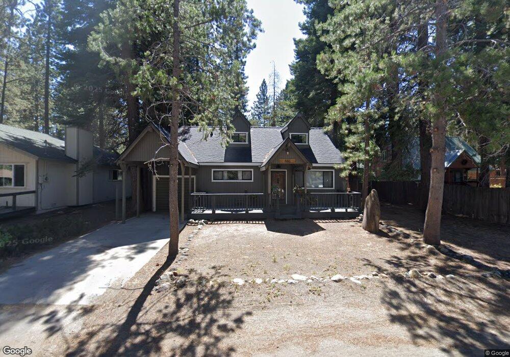
886 Tahoe Island Dr South Lake Tahoe, CA 96150
Estimated Value: $564,000 - $660,000
3
Beds
2
Baths
1,440
Sq Ft
$418/Sq Ft
Est. Value
About This Home
This home is located at 886 Tahoe Island Dr, South Lake Tahoe, CA 96150 and is currently estimated at $601,522, approximately $417 per square foot. 886 Tahoe Island Dr is a home located in El Dorado County with nearby schools including Tahoe Valley Elementary School, South Tahoe Middle School, and South Tahoe High School.
Ownership History
Date
Name
Owned For
Owner Type
Purchase Details
Closed on
Sep 25, 2023
Sold by
Johnson Residuary Trust
Bought by
Wolsfeld John and Wolsfeld Misty
Current Estimated Value
Purchase Details
Closed on
Apr 19, 2008
Sold by
Johnson Shirley J and Johnson Living Trust
Bought by
Johnson Shirley J and Johnson Residuary Trust
Purchase Details
Closed on
Sep 1, 1994
Sold by
Johnson Lloyd L and Johnson Shirley J
Bought by
Johnson Lloyd L and Johnson Shirley J
Create a Home Valuation Report for This Property
The Home Valuation Report is an in-depth analysis detailing your home's value as well as a comparison with similar homes in the area
Home Values in the Area
Average Home Value in this Area
Purchase History
| Date | Buyer | Sale Price | Title Company |
|---|---|---|---|
| Wolsfeld John | $500,000 | Chicago Title Company | |
| Johnson Shirley J | -- | None Available | |
| Johnson Lloyd L | -- | -- |
Source: Public Records
Tax History Compared to Growth
Tax History
| Year | Tax Paid | Tax Assessment Tax Assessment Total Assessment is a certain percentage of the fair market value that is determined by local assessors to be the total taxable value of land and additions on the property. | Land | Improvement |
|---|---|---|---|---|
| 2025 | $6,077 | $576,300 | $173,400 | $402,900 |
| 2024 | $6,077 | $565,000 | $170,000 | $395,000 |
| 2023 | $6,089 | $565,000 | $169,500 | $395,500 |
| 2022 | $1,488 | $129,781 | $19,497 | $110,284 |
| 2021 | $1,466 | $127,237 | $19,115 | $108,122 |
| 2020 | $1,445 | $125,933 | $18,919 | $107,014 |
| 2019 | $1,438 | $123,465 | $18,549 | $104,916 |
| 2018 | $1,407 | $121,045 | $18,186 | $102,859 |
| 2017 | $1,386 | $118,673 | $17,830 | $100,843 |
| 2016 | $1,359 | $116,347 | $17,481 | $98,866 |
| 2015 | $1,292 | $114,601 | $17,219 | $97,382 |
| 2014 | $1,292 | $112,358 | $16,883 | $95,475 |
Source: Public Records
Map
Nearby Homes
- 914 Tahoe Island Dr
- 776 Patricia Ln
- 2191 Butler Ave
- 741 Tahoe Island Dr
- 2244 Texas Ave
- 724 Tahoe Island Dr
- 2007 5th St Unit E
- 2007 5th St Unit A
- 803 Michael Dr
- 783 Michael Ct Unit Share B
- 783 Michael Ct
- 673 James Ave
- 2293 Eloise Ave Unit D
- 2337 Sky Meadows Ct
- 2071 Venice Dr Unit 294
- 2081 Venice Dr Unit 285
- 2081 Venice Dr Unit 280
- 2028 13th St
- 2185 Morro Dr
- 20149 U S 50
- 880 Tahoe Island Dr
- 890 Tahoe Island Dr
- 851 S Shore Dr
- 857 S Shore Dr
- 876 Tahoe Island Dr
- 894 Tahoe Island Dr
- 849 S Shore Dr
- 861 S Shore Dr
- 891 Tahoe Island Dr
- 881 Tahoe Island Dr
- 872 Tahoe Island Dr
- 847 S Shore Dr
- 895 Tahoe Island Dr
- 877 Tahoe Island Dr
- 868 Tahoe Island Dr
- 852 S Shore Dr
- 904 Tahoe Island Dr
- 873 Tahoe Island Dr
- 899 Tahoe Island Dr
- 856 S Shore Dr