Estimated Value: $265,801 - $298,000
3
Beds
2
Baths
1,732
Sq Ft
$162/Sq Ft
Est. Value
About This Home
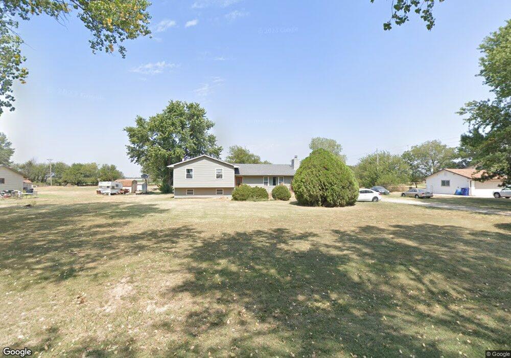
This home is located at 888 E 144th Ave N, Peck, KS 67120 and is currently estimated at $280,700, approximately $162 per square foot. 888 E 144th Ave N is a home located in Sumner County with nearby schools including Munson Primary School, Mulvane Grade School, and Mulvane Middle School.
Ownership History
Date
Name
Owned For
Owner Type
Purchase Details
Closed on
Jun 25, 2009
Sold by
O'Dell James L and O'Dell Donna J
Bought by
Lewis John T and Lewis Lori
Current Estimated Value
Home Financials for this Owner
Home Financials are based on the most recent Mortgage that was taken out on this home.
Original Mortgage
$117,551
Outstanding Balance
$74,828
Interest Rate
4.83%
Estimated Equity
$205,872
Purchase Details
Closed on
Mar 10, 2009
Sold by
First Federal Savings And Loan
Bought by
O'Dell James L and O'Dell Donna J
Purchase Details
Closed on
Dec 23, 2008
Sold by
Sheriff Of Sumner County Kansas
Bought by
First Federal Savings And Loan
Create a Home Valuation Report for This Property
The Home Valuation Report is an in-depth analysis detailing your home's value as well as a comparison with similar homes in the area
Purchase History
| Date | Buyer | Sale Price | Title Company |
|---|---|---|---|
| Lewis John T | -- | -- | |
| O'Dell James L | -- | -- | |
| First Federal Savings And Loan | $140,699 | -- |
Source: Public Records
Mortgage History
| Date | Status | Borrower | Loan Amount |
|---|---|---|---|
| Open | First Federal Savings And Loan | $117,551 |
Source: Public Records
Tax History
| Year | Tax Paid | Tax Assessment Tax Assessment Total Assessment is a certain percentage of the fair market value that is determined by local assessors to be the total taxable value of land and additions on the property. | Land | Improvement |
|---|---|---|---|---|
| 2025 | $3,275 | $27,101 | $4,983 | $22,118 |
| 2024 | $3,275 | $25,093 | $4,063 | $21,030 |
| 2023 | $2,986 | $22,811 | $1,840 | $20,971 |
| 2022 | $2,749 | $20,459 | $1,731 | $18,728 |
| 2021 | $2,508 | $18,246 | $1,639 | $16,607 |
| 2020 | $2,381 | $17,377 | $1,553 | $15,824 |
| 2019 | $2,361 | $16,571 | $1,214 | $15,357 |
| 2018 | $1,998 | $15,669 | $1,208 | $14,461 |
| 2017 | $2,052 | $15,669 | $1,208 | $14,461 |
| 2016 | $2,068 | $15,669 | $805 | $14,864 |
| 2015 | -- | $15,669 | $805 | $14,864 |
| 2014 | -- | $15,008 | $805 | $14,203 |
Source: Public Records
Map
Nearby Homes
- 00 E 119th St
- 00000 E 139th Ave N
- 1066 E 130th Ave N
- 704 E Gordon Bennett Dr
- 9160 S Broadway Ave
- 527 E Gordon Bennett Dr
- 0 Lot 22 Block 1 Gordon Bennett
- 1155 N Oliver Rd
- TBD S Bluff St
- 00000 N Pope Dr
- 1304 E 85th St S
- 1222 E 110th Ave N
- 420 E Nicole Cir
- 510 E Kirby St
- 0000 E 95th St S
- 8405 S Ida St
- 203 W Bridge St
- 8359 Victoria St
- 10100 S Rock Rd
- 217 E Filmore
- 884 E 144th Ave N
- 896 E 144th Ave N
- 874 E 144th Ave N
- 891 E 144th Ave N
- 870 E 144th Ave N
- 1442 N Crow Rd
- 869 E 144th Ave N
- 1441 N Crow Rd
- 868 E 144th Ave N
- 1438 N Crow Rd
- 1439 N Crow Rd
- 1434 N Estate Rd
- 1447 N Estate Rd
- 1445 N Estate Rd
- 1432 N Estate Rd
- 892 E 143rd Ave N
- 1437 N Crow Rd
- 1435 N Estate Rd
- 1430 N Estate Rd
- 1433 N Estate Rd
Your Personal Tour Guide
Ask me questions while you tour the home.