Estimated Value: $762,000 - $822,000
3
Beds
2
Baths
3,126
Sq Ft
$254/Sq Ft
Est. Value
About This Home
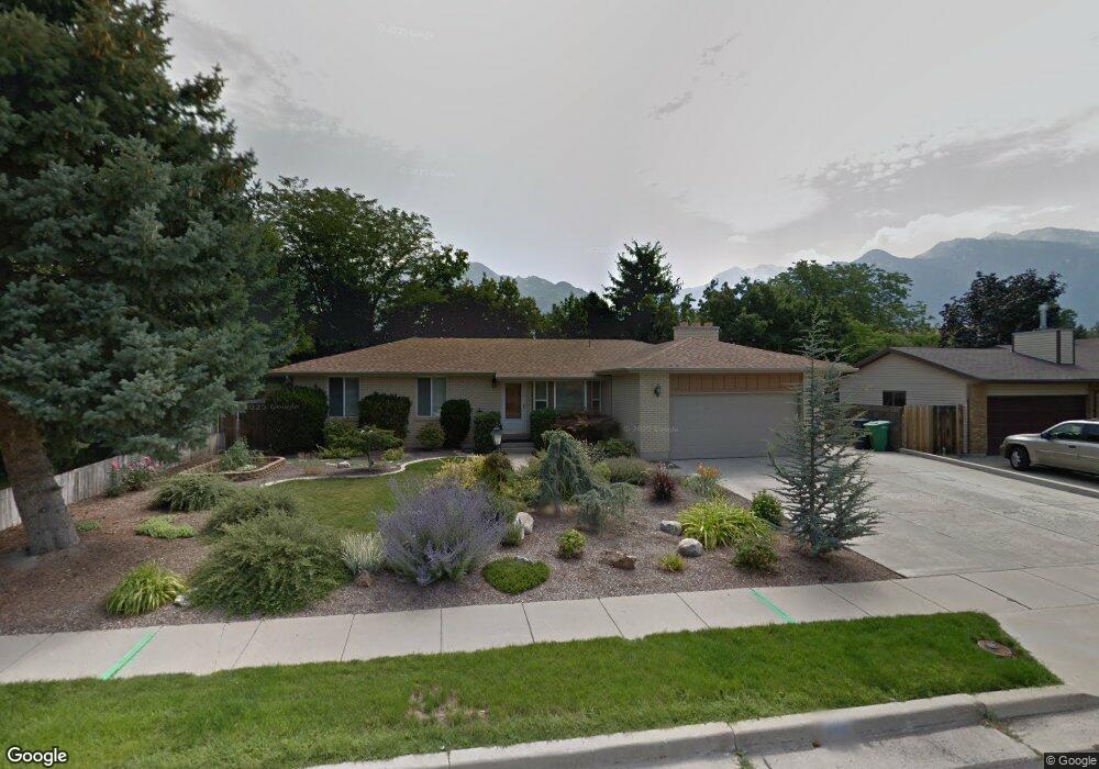
This home is located at 8889 Renegade Rd, Sandy, UT 84093 and is currently estimated at $795,481, approximately $254 per square foot. 8889 Renegade Rd is a home located in Salt Lake County with nearby schools including Quail Hollow Elementary School, Albion Middle School, and Brighton High School.
Ownership History
Date
Name
Owned For
Owner Type
Purchase Details
Closed on
Feb 17, 2023
Sold by
Mabey Patrick D
Bought by
Mabey Teresa and Phillips Deanne B
Current Estimated Value
Home Financials for this Owner
Home Financials are based on the most recent Mortgage that was taken out on this home.
Original Mortgage
$239,000
Outstanding Balance
$231,702
Interest Rate
6.48%
Mortgage Type
New Conventional
Estimated Equity
$563,779
Purchase Details
Closed on
Jun 20, 2013
Sold by
Buxton Catherine Michelle and Buxton Casey Lee
Bought by
Mabey Patrick D and Mabey Teresa
Home Financials for this Owner
Home Financials are based on the most recent Mortgage that was taken out on this home.
Original Mortgage
$292,000
Interest Rate
3.38%
Mortgage Type
New Conventional
Purchase Details
Closed on
Apr 2, 2008
Sold by
Buxton Catherine and Buxton Casey
Bought by
Buxton Catherine Michelle and Buxton Casey Lee
Home Financials for this Owner
Home Financials are based on the most recent Mortgage that was taken out on this home.
Original Mortgage
$331,000
Interest Rate
6.04%
Mortgage Type
New Conventional
Purchase Details
Closed on
Jun 7, 2006
Sold by
Willis Sandra D
Bought by
Buxton Casey and Buxton Catherine
Home Financials for this Owner
Home Financials are based on the most recent Mortgage that was taken out on this home.
Original Mortgage
$45,225
Interest Rate
6.21%
Mortgage Type
Stand Alone Second
Purchase Details
Closed on
Jan 16, 2002
Sold by
Willis Sandra D
Bought by
Willis Sandra D
Home Financials for this Owner
Home Financials are based on the most recent Mortgage that was taken out on this home.
Original Mortgage
$143,120
Interest Rate
6.63%
Purchase Details
Closed on
Nov 27, 2001
Sold by
Ward Ruth Sorenson
Bought by
Willis Sandra D
Home Financials for this Owner
Home Financials are based on the most recent Mortgage that was taken out on this home.
Original Mortgage
$143,120
Interest Rate
6.63%
Create a Home Valuation Report for This Property
The Home Valuation Report is an in-depth analysis detailing your home's value as well as a comparison with similar homes in the area
Home Values in the Area
Average Home Value in this Area
Purchase History
We collect this data history from publicly available records. To have your information removed, we recommend requesting removal directly through your county’s website.
| Date | Buyer | Sale Price | Title Company |
|---|---|---|---|
| Mabey Teresa | -- | Hickman Land Title Company | |
| Mabey Patrick D | -- | First American Title | |
| Buxton Catherine Michelle | -- | Security Title Ins Agency | |
| Buxton Casey | -- | Equity Title | |
| Willis Sandra D | -- | First American Title | |
| Willis Sandra D | -- | Sutherland Title |
Source: Public Records
Mortgage History
We collect this data history from publicly available records. To have your information removed, we recommend requesting removal directly through your county’s website.
| Date | Status | Borrower | Loan Amount |
|---|---|---|---|
| Open | Mabey Teresa | $239,000 | |
| Previous Owner | Mabey Patrick D | $292,000 | |
| Previous Owner | Buxton Catherine Michelle | $331,000 | |
| Previous Owner | Buxton Casey | $45,225 | |
| Previous Owner | Buxton Casey | $241,200 | |
| Previous Owner | Willis Sandra D | $143,120 |
Source: Public Records
Tax History
| Year | Tax Paid | Tax Assessment Tax Assessment Total Assessment is a certain percentage of the fair market value that is determined by local assessors to be the total taxable value of land and additions on the property. | Land | Improvement |
|---|---|---|---|---|
| 2025 | $4,106 | $777,200 | $225,600 | $551,600 |
| 2024 | $4,106 | $769,700 | $217,200 | $552,500 |
| 2023 | $3,850 | $720,400 | $208,800 | $511,600 |
| 2022 | $3,967 | $730,100 | $204,800 | $525,300 |
| 2021 | $3,572 | $559,700 | $155,400 | $404,300 |
| 2020 | $3,121 | $461,600 | $155,400 | $306,200 |
| 2019 | $3,018 | $435,500 | $146,600 | $288,900 |
| 2018 | $2,832 | $427,200 | $146,600 | $280,600 |
| 2017 | $2,816 | $406,500 | $146,600 | $259,900 |
| 2016 | $2,652 | $370,000 | $132,100 | $237,900 |
| 2015 | $2,755 | $356,400 | $146,600 | $209,800 |
| 2014 | $2,683 | $340,900 | $142,700 | $198,200 |
Source: Public Records
Map
Nearby Homes
- 2247 Willow Hills Dr
- 8752 Alta Cove Dr
- 2156 E Falcon Way
- 8649 Alta Cove Dr
- 8479 Escalante Dr
- 8585 Mount Majestic Rd
- 2774 Willow Wick Dr
- 1930 E Southbridge Way
- 2670 Bridger Blvd Unit 8
- 1924 E Viscounti Cove
- 8483 S Terrace Dr
- 8506 S Willow Creek Cove
- 8318 S Ridge Point Rd
- 8329 S Escalante Dr
- 1837 E Richard Rd
- 8291 Cravalan Cir
- 9510 S 2280 E
- 2152 E Creek Rd
- 8923 Cobble Crest Ln
- 8228 Set Point Cir
- 8888 Renegade Rd
- 8888 S Renegade Rd
- 2275 Renegade Rd
- 8891 N Forty Rd
- 8891 S Northforty Rd
- 8874 Renegade Rd
- 8891 Northforty Rd
- 8877 S Northforty Rd
- 2265 Renegade Rd
- 8901 Renegade Rd
- 2266 Willow Hills Dr
- 8889 S Renegade Rd
- 8875 S Renegade Rd
- 8875 Renegade Rd
- 2276 Renegade Rd
- 2275 E Willow Hills Dr
- 2275 Willow Hills Dr
- 8925 Northforty Rd
- 8925 S Northforty Rd
- 8890 Northforty Rd
Your Personal Tour Guide
Ask me questions while you tour the home.