
Seller's Agent in 2025
Marian Oost-Lievense
New Seabury Sotheby's International Realty
(203) 812-9570
80 in this area
120 Total Sales

Estimated Value: $1,083,000 - $1,126,680
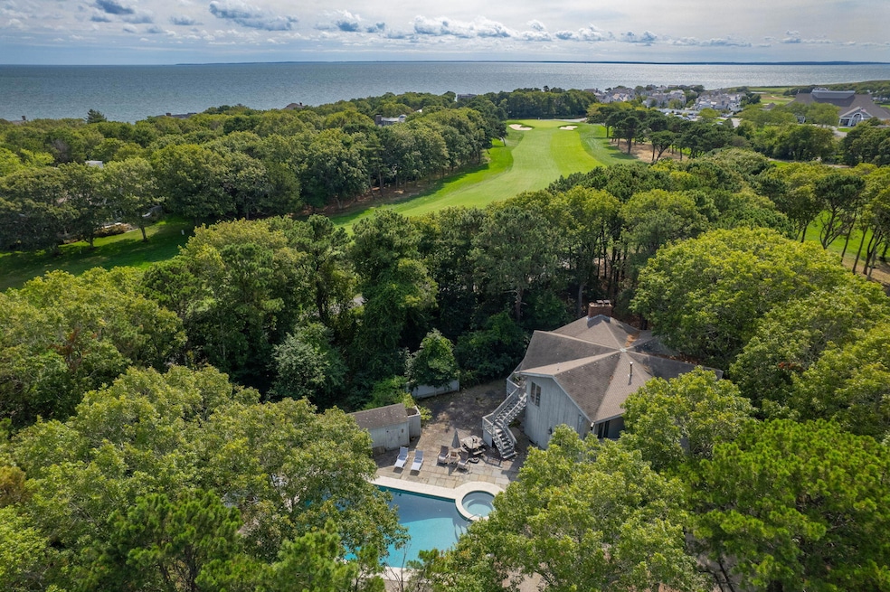
Have you been looking for the opportunity to create your dream home on the golf course? Would an oversized lot, approximately .7acre, alongside the 18th hole of the Ocean Course appeal to you? Have you been yearning to construct a home to enjoy for decades to come, creating lifetime memories as you watch your children grow, teach the grandkids golf, or just spend time with treasured friends? If this sounds enticing, you have come to the right place! This location is also conveniently located to the Clubhouse, as well as the Popponesset Inn and Marketplace. The home presently on the property is being sold as is. There is also a pool on site, and ample parking. This homesite provides a rare opportunity and is worth exploring! Come for a visit and let your imagination go to work!
Last Agent to Sell the Property
New Seabury Sotheby's International Realty License #9555091 Listed on: 09/15/2025
We collect this data history from publicly available records. To have your information removed, we recommend requesting removal directly through your county’s website.
| Date | Buyer | Sale Price | Title Company |
|---|---|---|---|
| Crocker Peter | $1,100,000 | -- | |
| Gildea Edward | -- | -- | |
| Gildea-Butler Mary | -- | -- | |
| Gildea Edward J | -- | -- |
We collect this data history from publicly available records. To have your information removed, we recommend requesting removal directly through your county’s website.
| Date | Status | Borrower | Loan Amount |
|---|---|---|---|
| Previous Owner | Gildea Edward J | $633,750 |
| Date | Event | Price | List to Sale | Price per Sq Ft |
|---|---|---|---|---|
| 12/15/2025 12/15/25 | Sold | $1,100,000 | +99999900.0% | $442 / Sq Ft |
| 09/21/2025 09/21/25 | Pending | -- | -- | -- |
| 09/15/2025 09/15/25 | For Sale | $1 | -- | $0 / Sq Ft |
| Year | Tax Paid | Tax Assessment Tax Assessment Total Assessment is a certain percentage of the fair market value that is determined by local assessors to be the total taxable value of land and additions on the property. | Land | Improvement |
|---|---|---|---|---|
| 2025 | $8,012 | $1,210,300 | $663,200 | $547,100 |
| 2024 | $6,739 | $1,048,100 | $526,400 | $521,700 |
| 2023 | $6,540 | $933,000 | $501,300 | $431,700 |
| 2022 | $6,142 | $751,800 | $392,700 | $359,100 |
| 2021 | $7,238 | $671,000 | $353,800 | $317,200 |
| 2020 | $5,883 | $647,200 | $340,200 | $307,000 |
| 2019 | $5,718 | $631,800 | $340,200 | $291,600 |
| 2018 | $6,678 | $629,600 | $359,500 | $270,100 |
| 2017 | $6,503 | $606,800 | $359,500 | $247,300 |
| 2016 | $5,881 | $636,500 | $404,400 | $232,100 |
| 2015 | $5,966 | $654,900 | $430,100 | $224,800 |
| 2014 | $6,056 | $644,900 | $422,700 | $222,200 |
Seller's Agent in 2025
Marian Oost-Lievense
New Seabury Sotheby's International Realty
(203) 812-9570
80 in this area
120 Total Sales
Seller Co-Listing Agent in 2025
Richard Coleman
New Seabury Sotheby's International Realty
(508) 233-3169
83 in this area
119 Total Sales
Source: Cape Cod & Islands Association of REALTORS®
MLS Number: 22504580
APN: MASH-000127-000027
Disclaimer: Certain information contained herein is derived from information provided by parties other than Homes.com. All information provided is deemed reliable, but is not guaranteed to be accurate and should be independently verified.
![]() All data relating to real estate for sale on this page comes from the Broker Reciprocity (BR) of the Cape Cod & Islands Multiple Listing Service, Inc. Detailed information about real estate listings held by brokerage firms other than CC&I Assoc. of REALTORS®, Inc. includes the name of the listing company. Neither the listing company nor CC&I Assoc. of REALTORS®, Inc. shall be responsible for any typographical errors, misinformation, misprints and shall be held totally harmless. The Broker providing this data believes it to be correct, but advises interested parties to confirm any item before relying on it in a purchase decision. All properties are subject to prior sale, changes, or withdrawal. Copyright 2026 © Cape Cod & Islands Multiple Listing Service, Inc. All rights reserved.
All data relating to real estate for sale on this page comes from the Broker Reciprocity (BR) of the Cape Cod & Islands Multiple Listing Service, Inc. Detailed information about real estate listings held by brokerage firms other than CC&I Assoc. of REALTORS®, Inc. includes the name of the listing company. Neither the listing company nor CC&I Assoc. of REALTORS®, Inc. shall be responsible for any typographical errors, misinformation, misprints and shall be held totally harmless. The Broker providing this data believes it to be correct, but advises interested parties to confirm any item before relying on it in a purchase decision. All properties are subject to prior sale, changes, or withdrawal. Copyright 2026 © Cape Cod & Islands Multiple Listing Service, Inc. All rights reserved.
Ask me questions while you tour the home.