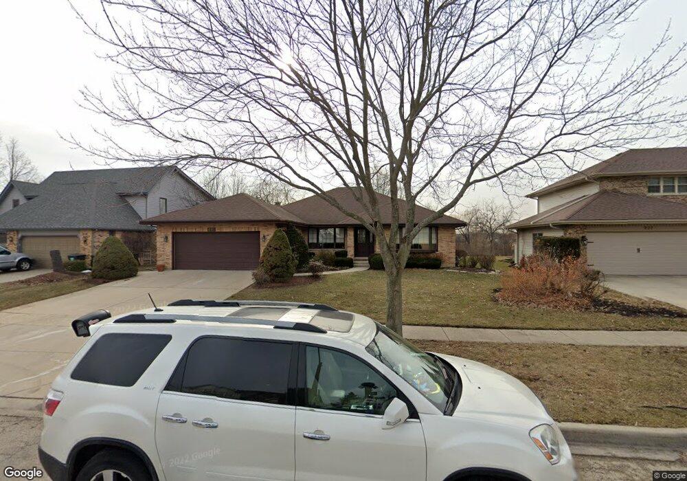
890 N Dexter Ln Hoffman Estates, IL 60169
South Hoffman Estates NeighborhoodEstimated Value: $529,000 - $594,000
4
Beds
2
Baths
2,250
Sq Ft
$245/Sq Ft
Est. Value
About This Home
This home is located at 890 N Dexter Ln, Hoffman Estates, IL 60169 and is currently estimated at $550,996, approximately $244 per square foot. 890 N Dexter Ln is a home located in Cook County with nearby schools including Hoover Math And Science Academy, Dwight D Eisenhower Junior High School, and Hoffman Estates High School.
Ownership History
Date
Name
Owned For
Owner Type
Purchase Details
Closed on
Jul 24, 2012
Sold by
Larouche Judith A
Bought by
Larouche Judith A and Judith A Larouche Living Trust
Current Estimated Value
Purchase Details
Closed on
Apr 13, 2012
Sold by
Larouche Judith A
Bought by
Larouche Judith A
Home Financials for this Owner
Home Financials are based on the most recent Mortgage that was taken out on this home.
Original Mortgage
$213,600
Interest Rate
3.9%
Mortgage Type
New Conventional
Purchase Details
Closed on
May 25, 2005
Sold by
Larouche David A J and Larouche Judith A
Bought by
Larouche David A J and Larouche Judith A
Purchase Details
Closed on
Jun 16, 2004
Sold by
Larouche David A J and Larouche Judith A
Bought by
Larouche David A J and Larouche Judith A
Create a Home Valuation Report for This Property
The Home Valuation Report is an in-depth analysis detailing your home's value as well as a comparison with similar homes in the area
Home Values in the Area
Average Home Value in this Area
Purchase History
| Date | Buyer | Sale Price | Title Company |
|---|---|---|---|
| Larouche Judith A | -- | None Available | |
| Larouche Judith A | -- | None Available | |
| Larouche David A J | -- | -- | |
| Larouche David A J | -- | -- |
Source: Public Records
Mortgage History
| Date | Status | Borrower | Loan Amount |
|---|---|---|---|
| Closed | Larouche Judith A | $213,600 |
Source: Public Records
Tax History
| Year | Tax Paid | Tax Assessment Tax Assessment Total Assessment is a certain percentage of the fair market value that is determined by local assessors to be the total taxable value of land and additions on the property. | Land | Improvement |
|---|---|---|---|---|
| 2025 | $8,086 | $47,000 | $9,910 | $37,090 |
| 2024 | $8,086 | $39,000 | $8,258 | $30,742 |
| 2023 | $9,754 | $39,000 | $8,258 | $30,742 |
| 2022 | $9,754 | $39,000 | $8,258 | $30,742 |
| 2021 | $8,645 | $32,463 | $5,780 | $26,683 |
| 2020 | $8,795 | $32,463 | $5,780 | $26,683 |
| 2019 | $8,753 | $36,070 | $5,780 | $30,290 |
| 2018 | $9,191 | $34,369 | $4,954 | $29,415 |
| 2017 | $9,061 | $34,369 | $4,954 | $29,415 |
| 2016 | $8,964 | $34,369 | $4,954 | $29,415 |
| 2015 | $9,034 | $30,750 | $4,335 | $26,415 |
| 2014 | $8,891 | $30,750 | $4,335 | $26,415 |
| 2013 | $8,646 | $30,750 | $4,335 | $26,415 |
Source: Public Records
Map
Nearby Homes
- 1300 Chatsworth Ln
- 1365 Newcastle Ln
- 845 Harmon Blvd
- 712 Scarbrough Cir Unit 126
- 1975 Leiter Way Unit 12002
- 1982 Leiter Way Unit 13004
- 1985 Leiter Way Unit 1102
- 1988 Leiter Way Unit 13001
- 1979 Leiter Way Unit 12004
- 1981 Leiter Way Unit 12005
- 1994 Leiter Way Unit 14003
- 1977 Leiter Way Unit 12003
- 1986 Leiter Way Unit 13002
- 1989 Leiter Way Unit 11004
- 1335 Blair Ln
- 1103 Southbridge Ln
- 658 Claridge Cir Unit 99
- 1708 Southbridge Ct
- 426 Argyll Ln
- 1360 Devonshire Ln
- 900 N Dexter Ln
- 880 N Dexter Ln
- 910 N Dexter Ln
- 895 N Dexter Ln
- 905 N Dexter Ln
- 885 N Dexter Ln
- 915 N Dexter Ln
- 920 N Dexter Ln
- 875 N Dexter Ln
- 860 N Dexter Ln
- 925 N Dexter Ln
- 865 N Dexter Ln
- 930 N Dexter Ln
- 900 N Dovington Dr
- 850 N Dexter Ln
- 890 N Dovington Dr
- 920 N Dovington Dr
- 855 N Dexter Ln
- 880 N Dovington Dr
- 935 N Dexter Ln
Your Personal Tour Guide
Ask me questions while you tour the home.