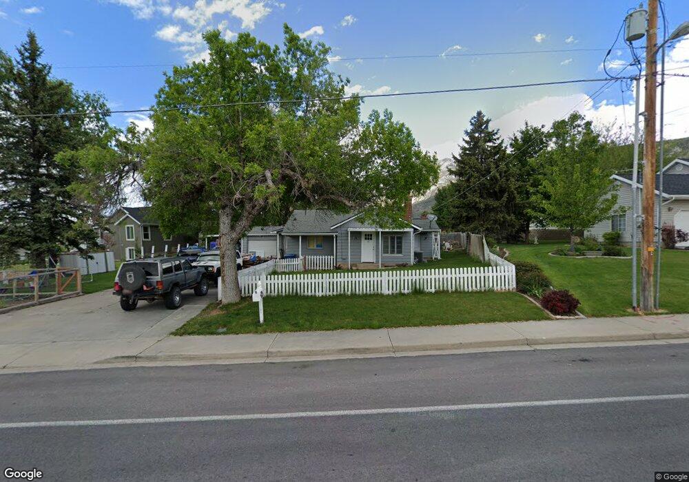
891 E 900 S Pleasant Grove, UT 84062
Estimated Value: $399,000 - $484,000
2
Beds
1
Bath
1,652
Sq Ft
$267/Sq Ft
Est. Value
About This Home
This home is located at 891 E 900 S, Pleasant Grove, UT 84062 and is currently estimated at $440,445, approximately $266 per square foot. 891 E 900 S is a home located in Utah County with nearby schools including Central Elementary School, Oak Canyon Junior High School, and Pleasant Grove High School.
Ownership History
Date
Name
Owned For
Owner Type
Purchase Details
Closed on
Mar 24, 2021
Sold by
Rosas Richard and Rosas Militza
Bought by
Rosas Richard and Rosas Militza
Current Estimated Value
Home Financials for this Owner
Home Financials are based on the most recent Mortgage that was taken out on this home.
Original Mortgage
$225,500
Outstanding Balance
$202,247
Interest Rate
2.73%
Mortgage Type
New Conventional
Estimated Equity
$238,198
Purchase Details
Closed on
Jul 20, 2018
Sold by
Hymas John Curtis and Hymas Desiree
Bought by
Rosas Richard and Mariscal Militza
Home Financials for this Owner
Home Financials are based on the most recent Mortgage that was taken out on this home.
Original Mortgage
$231,830
Interest Rate
4.5%
Mortgage Type
New Conventional
Purchase Details
Closed on
Jul 30, 2015
Sold by
Mcdonald Stanley T and Mcdonald Heather M
Bought by
Hymas John Curtis and Hymas Desiree
Home Financials for this Owner
Home Financials are based on the most recent Mortgage that was taken out on this home.
Original Mortgage
$162,011
Interest Rate
3.87%
Mortgage Type
FHA
Purchase Details
Closed on
May 13, 2009
Sold by
Zollinger Kathy M
Bought by
Mcdonald Stanley T and Mcdonald Heather M
Home Financials for this Owner
Home Financials are based on the most recent Mortgage that was taken out on this home.
Original Mortgage
$131,474
Interest Rate
4.8%
Mortgage Type
FHA
Purchase Details
Closed on
Nov 19, 2004
Sold by
Zollinger Kathy M
Bought by
Zollinger Kathy M
Home Financials for this Owner
Home Financials are based on the most recent Mortgage that was taken out on this home.
Original Mortgage
$100,300
Interest Rate
5.72%
Mortgage Type
New Conventional
Purchase Details
Closed on
Aug 26, 1999
Sold by
Zotti Patrick and Zotti Tina
Bought by
Zollinger Kathy M
Home Financials for this Owner
Home Financials are based on the most recent Mortgage that was taken out on this home.
Original Mortgage
$87,600
Interest Rate
7.47%
Purchase Details
Closed on
Mar 26, 1997
Sold by
Johnston Douglas F and Johnston Lowell Phillip
Bought by
Zotti Patrick and Zotti Tina
Home Financials for this Owner
Home Financials are based on the most recent Mortgage that was taken out on this home.
Original Mortgage
$68,175
Interest Rate
7.56%
Create a Home Valuation Report for This Property
The Home Valuation Report is an in-depth analysis detailing your home's value as well as a comparison with similar homes in the area
Home Values in the Area
Average Home Value in this Area
Purchase History
We collect this data history from publicly available records. To have your information removed, we recommend requesting removal directly through your county’s website.
| Date | Buyer | Sale Price | Title Company |
|---|---|---|---|
| Rosas Richard | -- | Utah First Title Insurance A | |
| Rosas Richard | -- | Vanguard Title Insurance Age | |
| Hymas John Curtis | -- | Cottonwood Title Ins Ag | |
| Mcdonald Stanley T | -- | Empire Land Title Inc | |
| Zollinger Kathy M | -- | Affiliated First Title Comp | |
| Zollinger Kathy M | -- | Meridian Title | |
| Zotti Patrick | -- | -- |
Source: Public Records
Mortgage History
We collect this data history from publicly available records. To have your information removed, we recommend requesting removal directly through your county’s website.
| Date | Status | Borrower | Loan Amount |
|---|---|---|---|
| Open | Rosas Richard | $225,500 | |
| Closed | Rosas Richard | $231,830 | |
| Previous Owner | Hymas John Curtis | $162,011 | |
| Previous Owner | Mcdonald Stanley T | $131,474 | |
| Previous Owner | Zollinger Kathy M | $100,300 | |
| Previous Owner | Zollinger Kathy M | $87,600 | |
| Previous Owner | Zotti Patrick | $68,175 |
Source: Public Records
Tax History
| Year | Tax Paid | Tax Assessment Tax Assessment Total Assessment is a certain percentage of the fair market value that is determined by local assessors to be the total taxable value of land and additions on the property. | Land | Improvement |
|---|---|---|---|---|
| 2025 | $1,461 | $185,955 | -- | -- |
| 2024 | $1,461 | $174,460 | $0 | $0 |
| 2023 | $1,442 | $176,165 | $0 | $0 |
| 2022 | $1,426 | $173,305 | $0 | $0 |
| 2021 | $1,182 | $218,800 | $126,800 | $92,000 |
| 2020 | $1,081 | $196,100 | $113,200 | $82,900 |
| 2019 | $1,006 | $188,800 | $105,900 | $82,900 |
| 2018 | $1,023 | $181,500 | $98,600 | $82,900 |
| 2017 | $951 | $89,870 | $0 | $0 |
| 2016 | $968 | $88,275 | $0 | $0 |
| 2015 | $980 | $84,645 | $0 | $0 |
| 2014 | $933 | $79,805 | $0 | $0 |
Source: Public Records
Map
Nearby Homes
- 826 S 875 E
- 1500 E 1000 S
- 795 S Locust Ave
- 710 S Locust Ave
- 793 E Orchard Dr
- 341 W 600 N
- 696 S Locust Ave
- 433 N Locust Ave
- 848 Apple Grove Ln
- 1022 E 450 S
- 517 N 80 W
- 1017 E 450 S
- 1172 E Murdock Dr
- 558 Harvest Moon Dr
- 628 N 120 E
- 1176 E 470 S
- 897 E 200 S Unit 10
- 180 S 950 E
- 1285 Mohican Cir
- 461 W 490 N
Your Personal Tour Guide
Ask me questions while you tour the home.