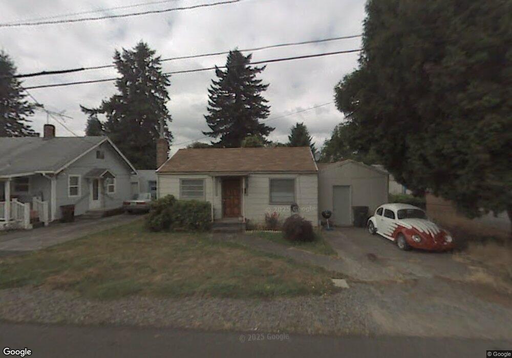
891 NW Mignonette Ave Gresham, OR 97030
Downtown Gresham NeighborhoodEstimated Value: $272,829 - $326,000
2
Beds
1
Bath
520
Sq Ft
$553/Sq Ft
Est. Value
About This Home
This home is located at 891 NW Mignonette Ave, Gresham, OR 97030 and is currently estimated at $287,707, approximately $553 per square foot. 891 NW Mignonette Ave is a home located in Multnomah County with nearby schools including Highland Elementary School, Clear Creek Middle School, and Gresham High School.
Ownership History
Date
Name
Owned For
Owner Type
Purchase Details
Closed on
Nov 30, 2009
Sold by
Coleman Jonni Lou
Bought by
Leckron David A and Leckron Carol J
Current Estimated Value
Purchase Details
Closed on
Jul 10, 1997
Sold by
Leckron Carol J
Bought by
Leckron David A and Leckron Carol J
Purchase Details
Closed on
May 30, 1995
Sold by
Leckron Carol Jean and Mcclinton John Lewis
Bought by
Leckron Carol Jean and Coleman Jonni Lou
Create a Home Valuation Report for This Property
The Home Valuation Report is an in-depth analysis detailing your home's value as well as a comparison with similar homes in the area
Home Values in the Area
Average Home Value in this Area
Purchase History
| Date | Buyer | Sale Price | Title Company |
|---|---|---|---|
| Leckron David A | $42,500 | None Available | |
| Leckron David A | -- | -- | |
| Leckron Carol Jean | -- | -- |
Source: Public Records
Tax History
| Year | Tax Paid | Tax Assessment Tax Assessment Total Assessment is a certain percentage of the fair market value that is determined by local assessors to be the total taxable value of land and additions on the property. | Land | Improvement |
|---|---|---|---|---|
| 2025 | $2,145 | $105,420 | -- | -- |
| 2024 | $2,054 | $102,350 | -- | -- |
| 2023 | $1,871 | $99,370 | $0 | $0 |
| 2022 | $1,819 | $96,480 | $0 | $0 |
| 2021 | $1,773 | $93,670 | $0 | $0 |
| 2020 | $1,668 | $90,950 | $0 | $0 |
| 2019 | $1,625 | $88,310 | $0 | $0 |
| 2018 | $1,549 | $85,740 | $0 | $0 |
| 2017 | $1,486 | $83,250 | $0 | $0 |
| 2016 | $1,311 | $80,830 | $0 | $0 |
Source: Public Records
Map
Nearby Homes
- 54 NW 13th St
- 0 NE 5th St
- 210 NE 5th St
- 318 NE Roberts Ave Unit 308
- 318 NE Roberts Ave Unit 203
- 660 NE 9th St
- 491 NE Elliott Ave
- 894 NE Linden Ave
- 1783 1791 NE Beech Place
- 349 NE 18th St
- 994 NW Wallula Ave
- 1325 NW 9th St
- 450 NE 22nd St
- 1113 W Powell Blvd
- 234 NE Cleveland Ave
- 159 SW Florence Ave Unit 64
- 159 SW Florence Ave
- 415 SE Roberts Ave
- 417 SE Roberts Ave
- 0 NE 6th St
- 845 NW Mignonette Ave
- 200 NW Division St
- 856 NW Victoria Ave
- 831 NW Mignonette Ave
- 914 NW Victoria Ave Unit 918
- 846 NW Victoria Ave
- 936 NW Victoria Ave
- 834 NW Victoria Ave
- 136 NW 10th Dr
- 890 NW Mignonette Ave Unit 892
- 823 NW Mignonette Ave
- 146 NW 10th Dr Unit Lower
- 840 NW Mignonette Ave
- 811 NW Mignonette Ave
- 124 NW 10th Dr
- 809 NW Mignonette Ave
- 822 NW Victoria Ave
- 824 NW Mignonette Ave
- 807 NW Mignonette Ave
- 911 NW Victoria Ave Unit 913
Your Personal Tour Guide
Ask me questions while you tour the home.