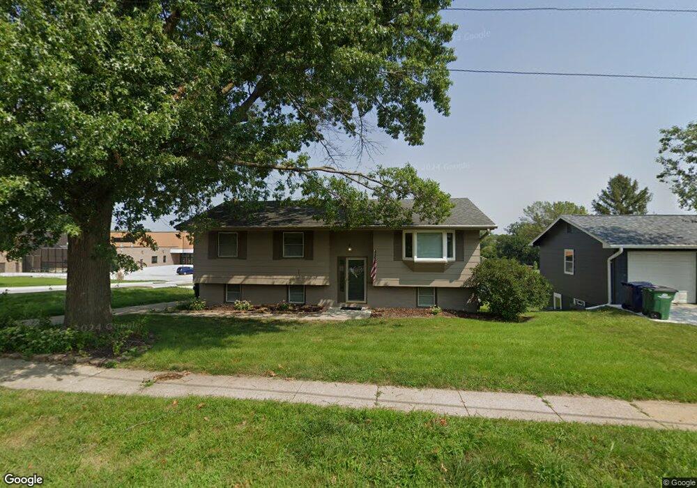
8913 Boston Ave Urbandale, IA 50322
Estimated Value: $251,729 - $275,000
2
Beds
2
Baths
1,101
Sq Ft
$239/Sq Ft
Est. Value
About This Home
This home is located at 8913 Boston Ave, Urbandale, IA 50322 and is currently estimated at $263,182, approximately $239 per square foot. 8913 Boston Ave is a home located in Polk County with nearby schools including Valerius Elementary School, Urbandale Middle School, and Urbandale High School.
Ownership History
Date
Name
Owned For
Owner Type
Purchase Details
Closed on
Sep 27, 2002
Sold by
Bell Allen A and Bell Dawn M
Bought by
Moore Joshua K and Moore Allison J
Current Estimated Value
Home Financials for this Owner
Home Financials are based on the most recent Mortgage that was taken out on this home.
Original Mortgage
$123,068
Outstanding Balance
$51,710
Interest Rate
6.32%
Mortgage Type
FHA
Estimated Equity
$211,472
Purchase Details
Closed on
Apr 8, 1999
Sold by
Munro Kenneth Robert and Munro Mary Lynne
Bought by
Bell Allen A and Bell Dawn M
Home Financials for this Owner
Home Financials are based on the most recent Mortgage that was taken out on this home.
Original Mortgage
$113,118
Interest Rate
7%
Mortgage Type
VA
Create a Home Valuation Report for This Property
The Home Valuation Report is an in-depth analysis detailing your home's value as well as a comparison with similar homes in the area
Home Values in the Area
Average Home Value in this Area
Purchase History
| Date | Buyer | Sale Price | Title Company |
|---|---|---|---|
| Moore Joshua K | $124,500 | -- | |
| Bell Allen A | $110,500 | -- |
Source: Public Records
Mortgage History
| Date | Status | Borrower | Loan Amount |
|---|---|---|---|
| Open | Moore Joshua K | $123,068 | |
| Previous Owner | Bell Allen A | $113,118 |
Source: Public Records
Tax History Compared to Growth
Tax History
| Year | Tax Paid | Tax Assessment Tax Assessment Total Assessment is a certain percentage of the fair market value that is determined by local assessors to be the total taxable value of land and additions on the property. | Land | Improvement |
|---|---|---|---|---|
| 2025 | $4,052 | $252,300 | $70,400 | $181,900 |
| 2024 | $4,052 | $223,700 | $61,600 | $162,100 |
| 2023 | $4,090 | $223,700 | $61,600 | $162,100 |
| 2022 | $4,042 | $190,600 | $53,800 | $136,800 |
| 2021 | $4,060 | $190,600 | $53,800 | $136,800 |
| 2020 | $3,992 | $181,700 | $51,300 | $130,400 |
| 2019 | $3,654 | $181,700 | $51,300 | $130,400 |
| 2018 | $3,522 | $158,900 | $44,000 | $114,900 |
| 2017 | $3,254 | $158,900 | $44,000 | $114,900 |
| 2016 | $3,174 | $144,300 | $39,600 | $104,700 |
| 2015 | $3,174 | $144,300 | $39,600 | $104,700 |
| 2014 | $2,766 | $138,600 | $37,400 | $101,200 |
Source: Public Records
Map
Nearby Homes
- 4517 90th St
- 4505 90th St
- 4500 90th St
- 37 89th St
- Lot 1 Hillsdale Dr
- 2908 88th Ct
- 3889 92nd Dr
- 8178 Dellwood Dr Unit 8178
- 3320 Patricia Dr
- 3808 Mary Lynn Dr
- 3805 Melanie Cir
- 1630 Parkside Ln
- 1600 Parkside Ln
- 1590 Parkside Ln
- 1550 Parkside Ln
- 3957 92nd Dr
- 8047 Dellwood Dr
- 3916 Greenview Dr
- 3900 Rolling Green Dr
- 8505 Airline Ave