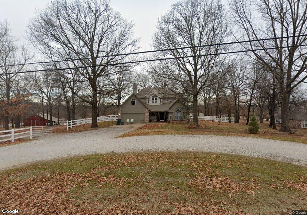
8917 W 157th St N Skiatook, OK 74070
Estimated Value: $370,813 - $453,000
4
Beds
3
Baths
2,212
Sq Ft
$182/Sq Ft
Est. Value
About This Home
This home is located at 8917 W 157th St N, Skiatook, OK 74070 and is currently estimated at $402,203, approximately $181 per square foot. 8917 W 157th St N is a home located in Osage County with nearby schools including Marrs Elementary School, Newman Middle School, and Skiatook High School.
Ownership History
Date
Name
Owned For
Owner Type
Purchase Details
Closed on
Jul 22, 2025
Sold by
Boyd David Michael and Boyd Glenda Annette
Bought by
Mike & Annette Boyd Family Trust and Boyd
Current Estimated Value
Purchase Details
Closed on
Jun 3, 2002
Sold by
Comeau Paul A Etal
Bought by
Boyd David M and Boyd Glenda A
Purchase Details
Closed on
Jul 23, 1999
Sold by
Oleo Jerry R and Oleo Sandra K
Bought by
Comeau Paul A Etal
Purchase Details
Closed on
Apr 4, 1995
Sold by
Skiatook Lake Dev Inc Etal
Bought by
Oleo Jerry R and Oleo Sandra K
Create a Home Valuation Report for This Property
The Home Valuation Report is an in-depth analysis detailing your home's value as well as a comparison with similar homes in the area
Home Values in the Area
Average Home Value in this Area
Purchase History
| Date | Buyer | Sale Price | Title Company |
|---|---|---|---|
| Mike & Annette Boyd Family Trust | -- | None Listed On Document | |
| Mike & Annette Boyd Family Trust | -- | None Listed On Document | |
| Boyd David M | $175,000 | -- | |
| Comeau Paul A Etal | $164,500 | -- | |
| Oleo Jerry R | $19,000 | -- |
Source: Public Records
Tax History Compared to Growth
Tax History
| Year | Tax Paid | Tax Assessment Tax Assessment Total Assessment is a certain percentage of the fair market value that is determined by local assessors to be the total taxable value of land and additions on the property. | Land | Improvement |
|---|---|---|---|---|
| 2025 | $2,842 | $29,562 | $2,784 | $26,778 |
| 2024 | $2,765 | $28,701 | $2,784 | $25,917 |
| 2023 | $2,765 | $27,865 | $2,784 | $25,081 |
| 2022 | $2,661 | $27,865 | $2,784 | $25,081 |
| 2021 | $2,670 | $27,865 | $2,784 | $25,081 |
| 2020 | $2,675 | $27,865 | $2,784 | $25,081 |
| 2019 | $2,626 | $27,021 | $2,784 | $24,237 |
| 2018 | $2,615 | $26,942 | $2,784 | $24,158 |
| 2017 | $2,574 | $26,157 | $2,784 | $23,373 |
| 2016 | $2,505 | $25,396 | $2,784 | $22,612 |
| 2015 | $2,410 | $24,656 | $2,784 | $21,872 |
| 2014 | $2,291 | $24,656 | $2,784 | $21,872 |
| 2013 | $2,388 | $24,656 | $2,784 | $21,872 |
Source: Public Records
Map
Nearby Homes
- 12470 Shoreline
- 0 N Choctaw Unit 2545995
- 14500 N Siddiki
- 9 Shoreline
- 6 Cross Oaks
- 9742 Oklahoma 20
- 505 S Buffalo
- 10054 W 159th St N
- 18053 N Lombard
- 0 Destiny Unit 2506609
- 8362 W Valley View Dr
- 8759 W Rogers Blvd
- 10939 State Highway 20
- 0 Lake Rd Unit 2527555
- 12 Oklahoma 20
- 10 E Highway 20
- 7 Oklahoma 20
- 69 E Highway 20
- 0000 Oklahoma 20
- 22 Cross Oaks Ct
- 8945 W 157th St N
- 8855 W 157th St N
- 8900 W 157th St N
- 8850 W 157th St N
- 0 W 157th St N
- null W 157th St N
- 9050 W 157th St N
- 9055 W 157th St N
- 9055 E 157th
- 8755 W 157th St N
- 15847 N 88th West Place
- 9074 W 157th St N
- 8750 W 157th St N
- 15815 N 88th Place W
- 8860 W 159th Place N
- 15815 N 88th West Place
- 9018 W 159th Place N
- 15745 N 92nd West Ave
- 9055 W 155th St N
- 8970 W 159th Place N