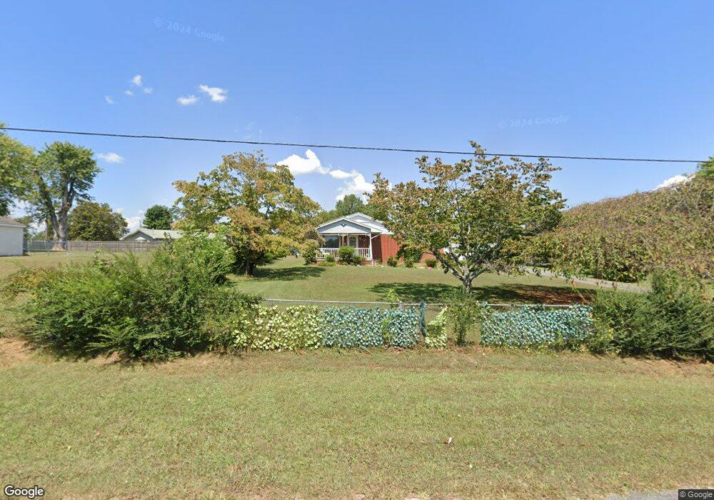
892 Forest Cir Sparta, TN 38583
Estimated Value: $190,000 - $272,000
--
Bed
2
Baths
1,456
Sq Ft
$157/Sq Ft
Est. Value
About This Home
This home is located at 892 Forest Cir, Sparta, TN 38583 and is currently estimated at $228,904, approximately $157 per square foot. 892 Forest Cir is a home located in White County with nearby schools including Doyle Elementary School, White County Middle School, and White County High School.
Ownership History
Date
Name
Owned For
Owner Type
Purchase Details
Closed on
Jul 1, 2003
Sold by
Kay Haddin
Bought by
Patrick Henry and Patrick Paula
Current Estimated Value
Home Financials for this Owner
Home Financials are based on the most recent Mortgage that was taken out on this home.
Original Mortgage
$85,000
Interest Rate
5.81%
Purchase Details
Closed on
May 8, 2003
Sold by
Ronald Pittman and Ronald Janice
Bought by
Lynita Sherrer
Home Financials for this Owner
Home Financials are based on the most recent Mortgage that was taken out on this home.
Original Mortgage
$85,000
Interest Rate
5.81%
Purchase Details
Closed on
Jun 18, 1986
Bought by
Pittman Ronald H and Pittman Janice L
Purchase Details
Closed on
May 18, 1986
Purchase Details
Closed on
Jan 1, 1979
Purchase Details
Closed on
Jan 2, 1900
Create a Home Valuation Report for This Property
The Home Valuation Report is an in-depth analysis detailing your home's value as well as a comparison with similar homes in the area
Home Values in the Area
Average Home Value in this Area
Purchase History
| Date | Buyer | Sale Price | Title Company |
|---|---|---|---|
| Patrick Henry | $65,000 | -- | |
| Lynita Sherrer | $80,000 | -- | |
| Pittman Ronald H | -- | -- | |
| -- | $41,000 | -- | |
| -- | $34,000 | -- | |
| -- | -- | -- |
Source: Public Records
Mortgage History
| Date | Status | Borrower | Loan Amount |
|---|---|---|---|
| Previous Owner | Not Available | $85,000 |
Source: Public Records
Tax History Compared to Growth
Tax History
| Year | Tax Paid | Tax Assessment Tax Assessment Total Assessment is a certain percentage of the fair market value that is determined by local assessors to be the total taxable value of land and additions on the property. | Land | Improvement |
|---|---|---|---|---|
| 2025 | $620 | $51,300 | $0 | $0 |
| 2024 | $620 | $30,225 | $3,375 | $26,850 |
| 2023 | $620 | $30,225 | $3,375 | $26,850 |
| 2022 | $620 | $30,225 | $3,375 | $26,850 |
| 2021 | $560 | $30,225 | $3,375 | $26,850 |
| 2020 | $560 | $27,325 | $3,375 | $23,950 |
| 2019 | $434 | $21,150 | $3,125 | $18,025 |
| 2018 | $434 | $21,150 | $3,125 | $18,025 |
| 2017 | $434 | $21,150 | $3,125 | $18,025 |
| 2016 | $434 | $21,150 | $3,125 | $18,025 |
| 2015 | $391 | $21,150 | $3,125 | $18,025 |
| 2014 | -- | $21,150 | $3,125 | $18,025 |
| 2013 | -- | $22,600 | $3,125 | $19,475 |
Source: Public Records
Map
Nearby Homes
- 0 Forest Cir
- 351 Forest Cir
- 570 Forest Cir
- 375 Golden Herren Rd
- 285 Middle Dr
- 1062 Pleasant Hill Rd
- 845 McMinnville Hwy
- 2190 Sullivan Knowles Rd
- 00 Loyalty Ln
- 0 Loyalty Ln
- 149 Central Cir
- 476 Sunset Dr
- 128 N Turner Dr
- 899 Messenger Rd
- 00 Hickory Valley Rd
- 1462 Franks Ferry Rd
- 1165 Sullivan Knowles Rd
- 241 Sparta Ave
- 116 Haley Ave
- 33.58 AC E Bethlehem Rd