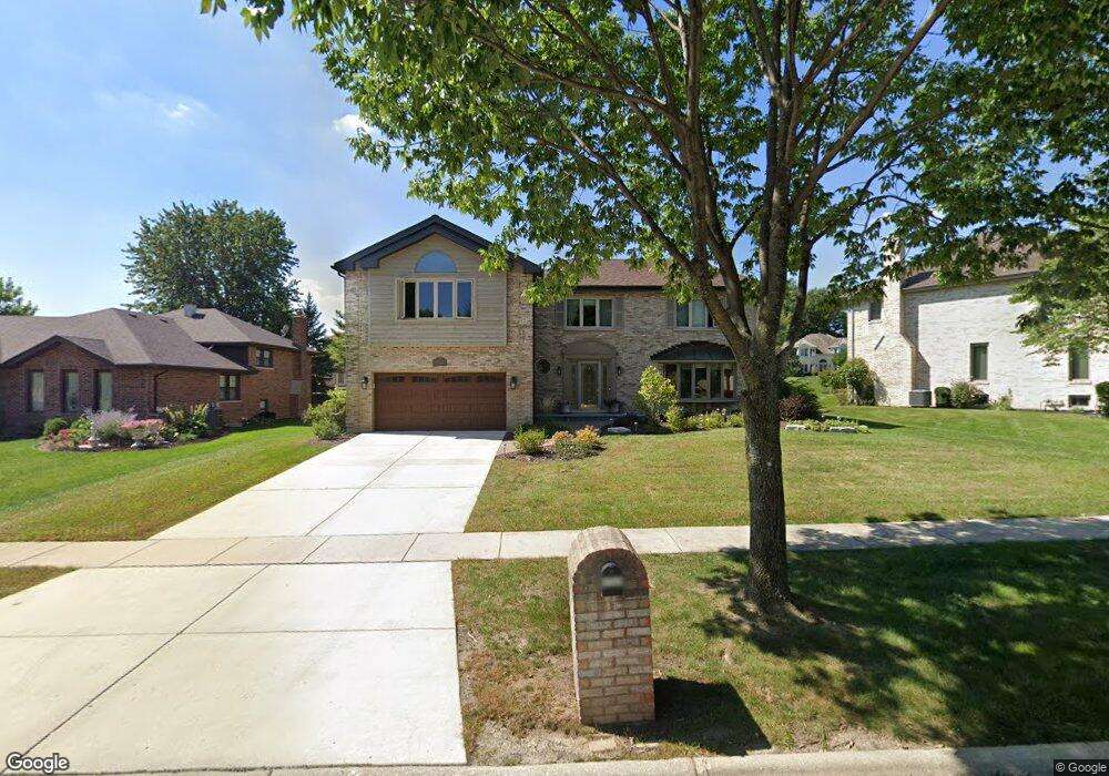
8928 Brandon Rd Darien, IL 60561
Estimated Value: $719,441 - $807,000
5
Beds
4
Baths
2,954
Sq Ft
$256/Sq Ft
Est. Value
About This Home
This home is located at 8928 Brandon Rd, Darien, IL 60561 and is currently estimated at $756,110, approximately $255 per square foot. 8928 Brandon Rd is a home located in DuPage County with nearby schools including Concord Elementary School, Cass Jr High School, and Hinsdale South High School.
Ownership History
Date
Name
Owned For
Owner Type
Purchase Details
Closed on
Jun 24, 2010
Sold by
Daugherty Eric and Daugherty Karen
Bought by
Derousse David and Derousse Laura
Current Estimated Value
Purchase Details
Closed on
Apr 17, 2006
Sold by
Waitley David W and Waitley Gail J
Bought by
Daugherty Eric and Daugherty Karen
Home Financials for this Owner
Home Financials are based on the most recent Mortgage that was taken out on this home.
Original Mortgage
$417,000
Interest Rate
6.48%
Mortgage Type
Fannie Mae Freddie Mac
Create a Home Valuation Report for This Property
The Home Valuation Report is an in-depth analysis detailing your home's value as well as a comparison with similar homes in the area
Home Values in the Area
Average Home Value in this Area
Purchase History
| Date | Buyer | Sale Price | Title Company |
|---|---|---|---|
| Derousse David | $485,000 | Atg | |
| Daugherty Eric | $552,000 | Ticor Title |
Source: Public Records
Mortgage History
| Date | Status | Borrower | Loan Amount |
|---|---|---|---|
| Previous Owner | Daugherty Eric | $417,000 |
Source: Public Records
Tax History Compared to Growth
Tax History
| Year | Tax Paid | Tax Assessment Tax Assessment Total Assessment is a certain percentage of the fair market value that is determined by local assessors to be the total taxable value of land and additions on the property. | Land | Improvement |
|---|---|---|---|---|
| 2024 | $11,750 | $189,887 | $61,733 | $128,154 |
| 2023 | $11,283 | $174,560 | $56,750 | $117,810 |
| 2022 | $10,771 | $166,900 | $54,260 | $112,640 |
| 2021 | $10,001 | $165,000 | $53,640 | $111,360 |
| 2020 | $9,825 | $161,730 | $52,580 | $109,150 |
| 2019 | $9,451 | $155,180 | $50,450 | $104,730 |
| 2018 | $9,483 | $158,830 | $50,180 | $108,650 |
| 2017 | $9,266 | $152,840 | $48,290 | $104,550 |
| 2016 | $10,188 | $163,480 | $46,090 | $117,390 |
| 2015 | $9,994 | $153,800 | $43,360 | $110,440 |
| 2014 | $9,837 | $149,540 | $42,160 | $107,380 |
| 2013 | $9,482 | $148,840 | $41,960 | $106,880 |
Source: Public Records
Map
Nearby Homes
- 8937 Tara Hill Rd
- 454 Andrus Rd
- 8825 Robert Rd
- 2221 Donegal Dr
- 8826 Carlisle Ct
- 8620 Washington St
- 19W047 Deerpath Ln
- 960 86th St
- 8511 Kearney Rd
- 8428 Creekside Ln
- 2845 87th St
- 9005 Gloucester Rd
- 9032 Lemont Rd
- 8557 Sandalwood Dr
- 1133 Central Ave
- 9014 Gloucester Rd
- Fremont Plan at Farmingdale Village
- Eden Plan at Farmingdale Village
- Danbury Plan at Farmingdale Village
- Calysta Plan at Farmingdale Village
- 8920 Brandon Rd
- 8932 Brandon Rd
- 8925 Middleton Rd
- 8936 Brandon Rd Unit 2
- 8912 Brandon Rd
- 8929 Middleton Rd
- 8929 Brandon Rd
- 8925 Brandon Rd
- 8933 Middleton Rd
- 8933 Brandon Rd
- 9000 Brandon Rd
- 8917 Brandon Rd
- 9001 Middleton Rd
- 9001 Brandon Rd
- 8913 Brandon Rd
- 8920 Middleton Rd
- 8916 Middleton Rd
- 9004 Brandon Rd
- 8909 Brandon Rd
- 8928 Kilkenny Dr