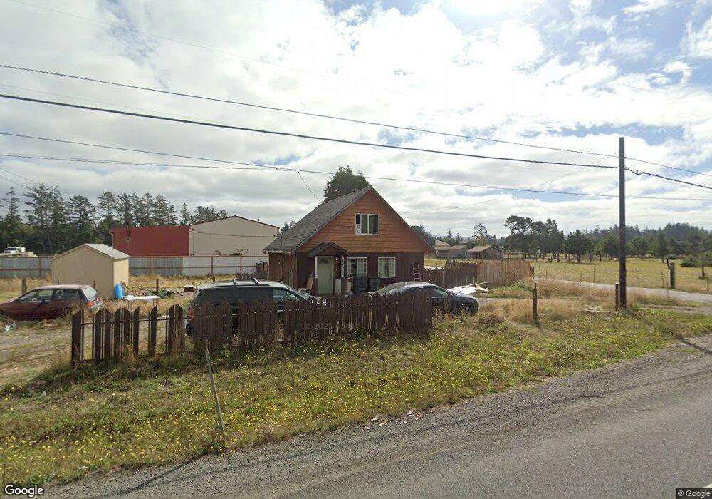
89611 Highway 101 Warrenton, OR 97146
Estimated Value: $304,000 - $507,000
3
Beds
1
Bath
833
Sq Ft
$507/Sq Ft
Est. Value
About This Home
This home is located at 89611 Highway 101, Warrenton, OR 97146 and is currently estimated at $422,197, approximately $506 per square foot. 89611 Highway 101 is a home located in Clatsop County with nearby schools including Seaside High School.
Ownership History
Date
Name
Owned For
Owner Type
Purchase Details
Closed on
Jul 2, 2018
Sold by
Hunter Katherine
Bought by
Shepherd Robert E and Shepherd Ashley M
Current Estimated Value
Home Financials for this Owner
Home Financials are based on the most recent Mortgage that was taken out on this home.
Original Mortgage
$207,070
Interest Rate
4.5%
Mortgage Type
New Conventional
Purchase Details
Closed on
Aug 18, 2015
Sold by
Hunter Alta M
Bought by
Hunter Katherine
Purchase Details
Closed on
Mar 2, 2006
Sold by
Cope Alexandra
Bought by
Hunter Alta M
Home Financials for this Owner
Home Financials are based on the most recent Mortgage that was taken out on this home.
Original Mortgage
$60,300
Interest Rate
6.08%
Mortgage Type
Stand Alone Second
Purchase Details
Closed on
Dec 7, 2004
Sold by
Wayne Bob
Bought by
Cope Alexandra
Create a Home Valuation Report for This Property
The Home Valuation Report is an in-depth analysis detailing your home's value as well as a comparison with similar homes in the area
Home Values in the Area
Average Home Value in this Area
Purchase History
| Date | Buyer | Sale Price | Title Company |
|---|---|---|---|
| Shepherd Robert E | $205,000 | Ticor Title | |
| Hunter Katherine | -- | None Available | |
| Hunter Alta M | $201,000 | Ticor Title Ins Co | |
| Cope Alexandra | $78,500 | Pacific Title Company |
Source: Public Records
Mortgage History
| Date | Status | Borrower | Loan Amount |
|---|---|---|---|
| Previous Owner | Shepherd Robert E | $207,070 | |
| Previous Owner | Hunter Alta M | $60,300 | |
| Previous Owner | Hunter Alta M | $140,700 |
Source: Public Records
Tax History Compared to Growth
Tax History
| Year | Tax Paid | Tax Assessment Tax Assessment Total Assessment is a certain percentage of the fair market value that is determined by local assessors to be the total taxable value of land and additions on the property. | Land | Improvement |
|---|---|---|---|---|
| 2024 | $2,293 | $179,848 | -- | -- |
| 2023 | $2,222 | $174,611 | $0 | $0 |
| 2022 | $2,165 | $169,526 | $0 | $0 |
| 2021 | $2,117 | $164,589 | $0 | $0 |
| 2020 | $2,065 | $159,796 | $0 | $0 |
| 2019 | $1,955 | $155,142 | $0 | $0 |
| 2018 | $1,920 | $150,624 | $0 | $0 |
| 2017 | $1,849 | $146,238 | $0 | $0 |
| 2016 | $1,557 | $141,979 | $56,374 | $85,605 |
| 2015 | $1,493 | $137,845 | $54,733 | $83,112 |
| 2014 | $1,470 | $133,831 | $0 | $0 |
| 2013 | -- | $129,934 | $0 | $0 |
Source: Public Records
Map
Nearby Homes
- 33467 SW Old Pine Dr
- 0 Seales Rd
- 0 Dellmoor Loop
- 000 Dellmoor Loop
- 89728 Ocean Dr
- 80654 Polo Ridge Rd
- 80654 Polo Ridge Rd
- 0 Vacant Lot Manion Dr
- 90023 Manion Dr
- VL Hawkins Rd
- 0 Hawkins Rd
- 33765 Lake Front Dr
- 90114 Manion Dr
- 33455 Bing Ln
- 90214 Hobie Rd
- 89026 Ocean Dr
- 90238 Hobie Rd
- 90250 Hobie Rd
- 89062 Pinehurst Rd
- 89611 Hwy 101
- 89635 Highway 101
- 89635 Hwy 101
- 89635 Oregon Coast Hwy
- 89652 Westlake Acres Dr
- 89652 W Lake Acres Rd
- 89603 Highway 101
- 89603 Hwy 101
- 89657 Highway 101
- 89657 Hwy 101
- 89657 U S 101
- 89595 Highway 101
- 89654 Dellmoor Loop Unit 89646
- 89563 Highway 101
- 33484 Westlake Ln
- 89547 Highway 101
- 89532 Hwy 101
- 33485 SW Old Pine Dr
- 89665 Dellmoor Loop
- 89527 Highway 101