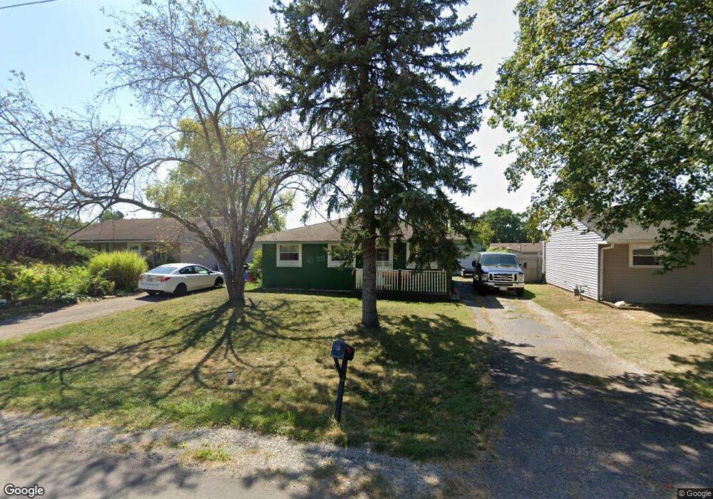
897 Hilock Rd Columbus, OH 43207
Obetz-Lockbourne NeighborhoodEstimated Value: $152,000 - $161,000
3
Beds
1
Bath
896
Sq Ft
$175/Sq Ft
Est. Value
About This Home
This home is located at 897 Hilock Rd, Columbus, OH 43207 and is currently estimated at $157,152, approximately $175 per square foot. 897 Hilock Rd is a home located in Franklin County with nearby schools including Parsons Elementary School, Buckeye Middle School, and Marion-Franklin High School.
Ownership History
Date
Name
Owned For
Owner Type
Purchase Details
Closed on
Jun 25, 2015
Sold by
Fultz Dorothy Irene and Fultz Dorothy I
Bought by
Devine Kenneth L
Current Estimated Value
Home Financials for this Owner
Home Financials are based on the most recent Mortgage that was taken out on this home.
Original Mortgage
$63,050
Outstanding Balance
$24,024
Interest Rate
3.86%
Mortgage Type
New Conventional
Estimated Equity
$133,128
Purchase Details
Closed on
Nov 27, 1961
Bought by
Fultz William T
Create a Home Valuation Report for This Property
The Home Valuation Report is an in-depth analysis detailing your home's value as well as a comparison with similar homes in the area
Home Values in the Area
Average Home Value in this Area
Purchase History
| Date | Buyer | Sale Price | Title Company |
|---|---|---|---|
| Devine Kenneth L | $65,000 | None Available | |
| Fultz William T | -- | -- |
Source: Public Records
Mortgage History
| Date | Status | Borrower | Loan Amount |
|---|---|---|---|
| Open | Devine Kenneth L | $63,050 |
Source: Public Records
Tax History Compared to Growth
Tax History
| Year | Tax Paid | Tax Assessment Tax Assessment Total Assessment is a certain percentage of the fair market value that is determined by local assessors to be the total taxable value of land and additions on the property. | Land | Improvement |
|---|---|---|---|---|
| 2024 | $2,100 | $46,800 | $16,240 | $30,560 |
| 2023 | $2,074 | $46,795 | $16,240 | $30,555 |
| 2022 | $1,151 | $22,190 | $8,680 | $13,510 |
| 2021 | $1,153 | $22,190 | $8,680 | $13,510 |
| 2020 | $1,154 | $22,190 | $8,680 | $13,510 |
| 2019 | $1,174 | $19,360 | $7,560 | $11,800 |
| 2018 | $926 | $19,360 | $7,560 | $11,800 |
| 2017 | $1,174 | $19,360 | $7,560 | $11,800 |
| 2016 | $1,329 | $20,060 | $4,310 | $15,750 |
| 2015 | $680 | $20,060 | $4,310 | $15,750 |
| 2014 | $682 | $20,060 | $4,310 | $15,750 |
| 2013 | $367 | $21,105 | $4,515 | $16,590 |
Source: Public Records
Map
Nearby Homes
- 884 Bruckner Rd
- 1138 Hilock Rd
- 1138 Hilock Rd Unit 35
- 860 Basswood Rd
- 3302 Hilock Place
- 780 Basswood Rd
- 1124 Rumsey Rd
- 1085 Williams Rd
- 0 Williams Rd
- 696 Williams Rd
- 1633-1635 E Greenway Ave
- 1292 Moundview Ave
- 3573 S Champion Ave
- 1118 Maplewood Rd
- 3551 Groveport Rd
- 1068 Tobi Dr
- 1382 Southfield Dr S
- 3161 Lewis Rd
- 3018 Woodway Rd
- 1450 Felix Dr