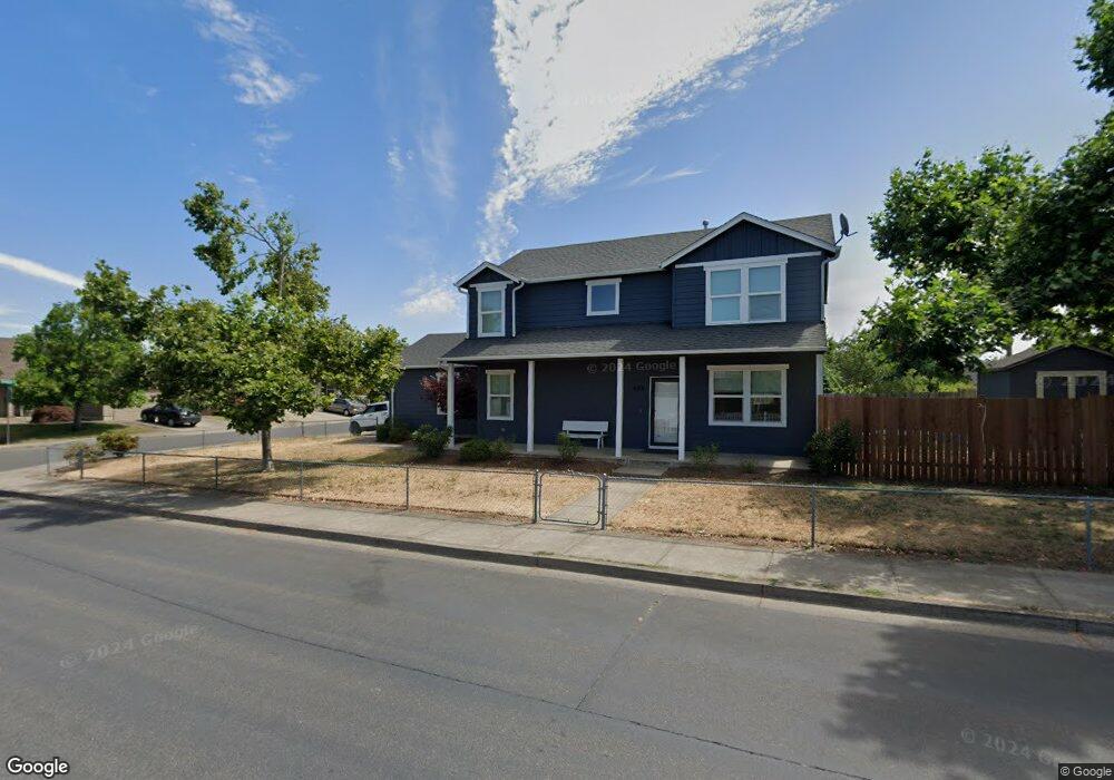
898 N 1st St Creswell, OR 97426
Estimated Value: $381,000 - $515,000
3
Beds
3
Baths
2,052
Sq Ft
$225/Sq Ft
Est. Value
About This Home
This home is located at 898 N 1st St, Creswell, OR 97426 and is currently estimated at $461,801, approximately $225 per square foot. 898 N 1st St is a home located in Lane County with nearby schools including Creslane Elementary School, Creswell Middle School, and Creswell High School.
Ownership History
Date
Name
Owned For
Owner Type
Purchase Details
Closed on
Oct 24, 2016
Sold by
The Bank Of New York Mellon
Bought by
Seiber Andrew J and Seiber Camille M
Current Estimated Value
Home Financials for this Owner
Home Financials are based on the most recent Mortgage that was taken out on this home.
Original Mortgage
$199,500
Outstanding Balance
$159,302
Interest Rate
3.42%
Mortgage Type
New Conventional
Estimated Equity
$302,499
Purchase Details
Closed on
Mar 10, 2016
Sold by
Hodge Carola M and Hodge Jerry L
Bought by
The Bank Of New York Mellon and The Bank Of New York
Purchase Details
Closed on
Oct 13, 2005
Sold by
Ganleany Lawrence E and Ganleany Delanie M
Bought by
Hodge Jerry L and Hodge Carola M
Home Financials for this Owner
Home Financials are based on the most recent Mortgage that was taken out on this home.
Original Mortgage
$22,500
Interest Rate
5.63%
Mortgage Type
Credit Line Revolving
Create a Home Valuation Report for This Property
The Home Valuation Report is an in-depth analysis detailing your home's value as well as a comparison with similar homes in the area
Home Values in the Area
Average Home Value in this Area
Purchase History
| Date | Buyer | Sale Price | Title Company |
|---|---|---|---|
| Seiber Andrew J | $210,000 | Fidelity Natl Title Of Or | |
| The Bank Of New York Mellon | $200,000 | Accommodation | |
| Hodge Jerry L | $225,000 | First American |
Source: Public Records
Mortgage History
| Date | Status | Borrower | Loan Amount |
|---|---|---|---|
| Open | Seiber Andrew J | $199,500 | |
| Previous Owner | Hodge Jerry L | $22,500 | |
| Previous Owner | Hodge Jerry L | $180,000 |
Source: Public Records
Tax History Compared to Growth
Tax History
| Year | Tax Paid | Tax Assessment Tax Assessment Total Assessment is a certain percentage of the fair market value that is determined by local assessors to be the total taxable value of land and additions on the property. | Land | Improvement |
|---|---|---|---|---|
| 2025 | $4,126 | $251,392 | -- | -- |
| 2024 | $3,086 | $244,070 | -- | -- |
| 2023 | $3,086 | $236,962 | $0 | $0 |
| 2022 | $3,324 | $230,061 | $0 | $0 |
| 2021 | $3,211 | $223,361 | $0 | $0 |
| 2020 | $3,166 | $216,856 | $0 | $0 |
| 2019 | $3,096 | $210,540 | $0 | $0 |
| 2018 | $3,053 | $198,454 | $0 | $0 |
| 2017 | $2,962 | $198,454 | $0 | $0 |
| 2016 | $3,033 | $192,674 | $0 | $0 |
| 2015 | $2,924 | $187,062 | $0 | $0 |
| 2014 | $2,899 | $181,614 | $0 | $0 |
Source: Public Records
Map
Nearby Homes
- 83354 N Pacific Hwy
- 692 N 1st St
- 689 Blue Jay Loop
- 156 N 1st St
- 368 Hillegas Ave
- 700 N Mill St Unit 109
- 700 N Mill St
- 33465 Irish Ln
- 460 Meadow Ln
- 491 Ironwood Loop
- 685 St Andrews Loop
- 589 Mary Neal Ln
- 375 Sunday Dr
- 336 Sunday Dr
- 316 Sunday Dr
- 521 S 7th St
- 0 Holbrook Ln Unit 339588620
- 370 Magnolia Dr
- 1 Queens Ave Unit 1
- 645 Boulder Loop