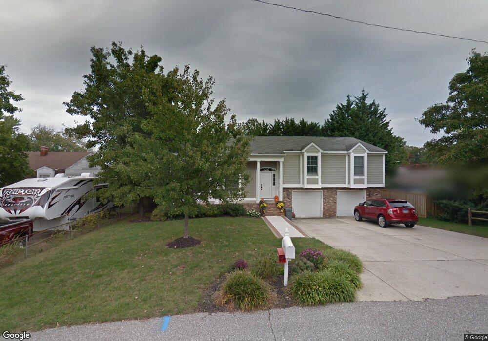
899 Wilson Rd Arnold, MD 21012
Estimated Value: $500,000 - $617,000
Studio
3
Baths
1,680
Sq Ft
$325/Sq Ft
Est. Value
About This Home
This home is located at 899 Wilson Rd, Arnold, MD 21012 and is currently estimated at $546,253, approximately $325 per square foot. 899 Wilson Rd is a home located in Anne Arundel County with nearby schools including Belvedere Elementary School, Severn River Middle School, and Broadneck High School.
Ownership History
Date
Name
Owned For
Owner Type
Purchase Details
Closed on
Nov 15, 1991
Sold by
Chisholm & Sons Inc
Bought by
Chisholm Robert K and Chisholm Sandra L
Current Estimated Value
Home Financials for this Owner
Home Financials are based on the most recent Mortgage that was taken out on this home.
Original Mortgage
$111,585
Interest Rate
8.69%
Purchase Details
Closed on
Jul 16, 1991
Sold by
Kruppa Wm S
Bought by
Chisholm & Sons Inc
Create a Home Valuation Report for This Property
The Home Valuation Report is an in-depth analysis detailing your home's value as well as a comparison with similar homes in the area
Home Values in the Area
Average Home Value in this Area
Purchase History
| Date | Buyer | Sale Price | Title Company |
|---|---|---|---|
| Chisholm Robert K | $110,000 | -- | |
| Chisholm & Sons Inc | $30,000 | -- |
Source: Public Records
Mortgage History
| Date | Status | Borrower | Loan Amount |
|---|---|---|---|
| Closed | Chisholm Robert K | $111,585 |
Source: Public Records
Tax History
| Year | Tax Paid | Tax Assessment Tax Assessment Total Assessment is a certain percentage of the fair market value that is determined by local assessors to be the total taxable value of land and additions on the property. | Land | Improvement |
|---|---|---|---|---|
| 2025 | $3,373 | $418,833 | -- | -- |
| 2024 | $3,373 | $397,800 | $231,000 | $166,800 |
| 2023 | $3,270 | $380,667 | $0 | $0 |
| 2022 | $3,050 | $363,533 | $0 | $0 |
| 2020 | $2,893 | $337,200 | $0 | $0 |
| 2019 | $2,844 | $328,000 | $0 | $0 |
| 2018 | $3,233 | $318,800 | $162,000 | $156,800 |
| 2017 | $2,682 | $313,567 | $0 | $0 |
| 2016 | -- | $308,333 | $0 | $0 |
| 2015 | -- | $303,100 | $0 | $0 |
| 2014 | -- | $303,100 | $0 | $0 |
Source: Public Records
Map
Nearby Homes
- 805 Barrett Ave
- 319 Alameda Pkwy
- 413 Ridgeview Ct
- 856 Imperial Rd
- 859 Birchwood Ct
- 854 Imperial Rd
- 852 Birchwood Ct
- 308 Clifton Ave
- 406 Elmwood Ct
- 404 Alameda Pkwy
- 876 Nancy Lynn Ln
- 930 Whitstable Blvd
- 797 David Dr
- 1050 Brightleaf Dr
- 792 Match Point Dr
- 1108 Silverleaf Dr
- 243 and 245 Haverton Rd
- 303 Ternwing Dr
- 1078 Brightleaf Ct
- 1082 Brightleaf Ct
- 402 Broadwater Rd
- 897 Wilson Rd
- 789 Harmony Ave
- 791 Harmony Ave
- 895 Wilson Rd
- 787 Harmony Ave
- 340 Broadwater Rd
- 801 Harmony Ave
- 800 Barrett Ave
- 785 Harmony Ave
- 803 Harmony Ave
- 800A Barrett Ave
- 893 Wilson Rd
- 800A Barrett Avenue A
- 783 Harmony Ave
- 805 Harmony Ave
- 800 Harmony Ave
- 790 Harmony Ave
- 788 Harmony Ave
- 801 Barrett Ave
Your Personal Tour Guide
Ask me questions while you tour the home.