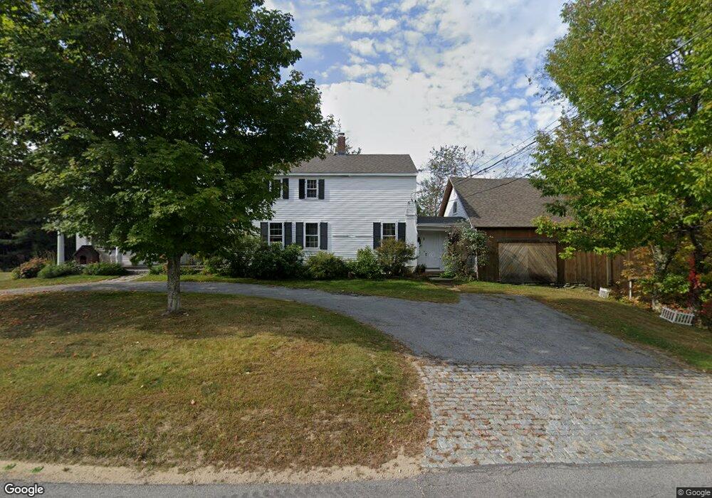
9 1st Crown Point Rd Strafford, NH 03884
Estimated Value: $541,695 - $917,000
5
Beds
3
Baths
3,772
Sq Ft
$182/Sq Ft
Est. Value
About This Home
This home is located at 9 1st Crown Point Rd, Strafford, NH 03884 and is currently estimated at $687,174, approximately $182 per square foot. 9 1st Crown Point Rd is a home located in Strafford County with nearby schools including Strafford School and Coe-Brown Northwood Academy.
Ownership History
Date
Name
Owned For
Owner Type
Purchase Details
Closed on
Jan 7, 2013
Sold by
Zullo-Moreno Laurie A
Bought by
Laurie Zullo Moreno Re and Zullo-Moreno Laurie
Current Estimated Value
Home Financials for this Owner
Home Financials are based on the most recent Mortgage that was taken out on this home.
Original Mortgage
$212,000
Outstanding Balance
$147,266
Interest Rate
3.35%
Mortgage Type
Purchase Money Mortgage
Estimated Equity
$539,908
Create a Home Valuation Report for This Property
The Home Valuation Report is an in-depth analysis detailing your home's value as well as a comparison with similar homes in the area
Home Values in the Area
Average Home Value in this Area
Purchase History
| Date | Buyer | Sale Price | Title Company |
|---|---|---|---|
| Laurie Zullo Moreno Re | -- | -- |
Source: Public Records
Mortgage History
| Date | Status | Borrower | Loan Amount |
|---|---|---|---|
| Open | Laurie Zullo Moreno Re | $212,000 |
Source: Public Records
Tax History Compared to Growth
Tax History
| Year | Tax Paid | Tax Assessment Tax Assessment Total Assessment is a certain percentage of the fair market value that is determined by local assessors to be the total taxable value of land and additions on the property. | Land | Improvement |
|---|---|---|---|---|
| 2024 | $7,145 | $361,600 | $69,000 | $292,600 |
| 2023 | $6,740 | $361,600 | $69,000 | $292,600 |
| 2022 | $6,194 | $361,600 | $69,000 | $292,600 |
| 2021 | $6,673 | $361,500 | $69,000 | $292,500 |
| 2020 | $7,633 | $297,600 | $64,900 | $232,700 |
| 2019 | $6,985 | $297,600 | $64,900 | $232,700 |
| 2018 | $6,917 | $292,700 | $64,900 | $227,800 |
| 2016 | $6,220 | $292,700 | $64,900 | $227,800 |
| 2015 | $6,214 | $284,900 | $78,800 | $206,100 |
| 2014 | $6,598 | $284,900 | $78,800 | $206,100 |
| 2013 | $6,462 | $284,900 | $78,800 | $206,100 |
| 2012 | $6,376 | $284,900 | $78,800 | $206,100 |
Source: Public Records
Map
Nearby Homes
- 948 Strafford Rd
- 345 Dry Hill Rd
- 243 Second Crown Point Rd
- 86 Long Shores Dr
- 68 Berry River Rd
- 38 Strafford Rd
- 0 Long Shores Dr Unit 5057687
- 83 Sloper Rd
- 0 Sloper Rd Unit 6
- 272 Walnut St
- 217-13 Washington St
- 212-0003-01 Washington St
- 207-002 Washington St
- 40 Dry Hill Rd Unit Lot 0250/0006/0000
- 10 Blue Hills Dr
- 00 Squire Rd
- 8 Juniper Ln
- Map 220 Lot 16 Four Rod Rd
- 395 Greenhill Rd
- 81 Hansonville Rd
- 201 Strafford Rd
- 6 Kristie Ln
- 292 Pond Hill Rd
- 0 Strafford Rd
- 00 1st Crown Point Rd
- 0 1st Crown Point Rd
- 500 Pond Hill Rd
- 7 Jodi Ln
- 743 Strafford Rd
- 14 Kristie Ln
- 501 Pond Hill Rd
- Map 16 Lot 1 Strafford Rd
- 740 Strafford Rd
- 22 Kristie Ln
- 201-13-1 Strafford Route 202a Rd
- 734 Strafford
- 25 Jodi Ln
- 481 Pond Hill Rd
- 727 Strafford Rd
- 29 Jodi Ln