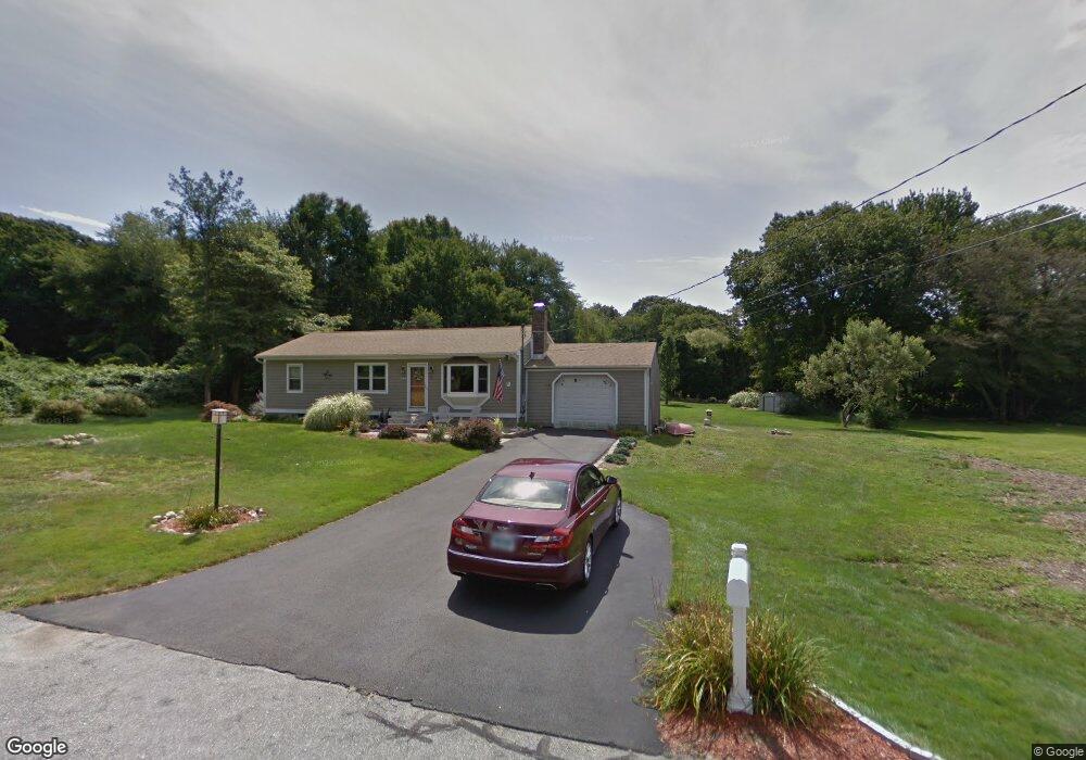
9 Barone Rd Niantic, CT 06357
Estimated Value: $606,851 - $693,000
3
Beds
3
Baths
1,943
Sq Ft
$327/Sq Ft
Est. Value
About This Home
This home is located at 9 Barone Rd, Niantic, CT 06357 and is currently estimated at $634,713, approximately $326 per square foot. 9 Barone Rd is a home located in New London County with nearby schools including East Lyme Middle School, East Lyme High School, and The Light House Voc-Ed Center.
Ownership History
Date
Name
Owned For
Owner Type
Purchase Details
Closed on
May 16, 2001
Sold by
Finucan Matthew T
Bought by
Degraff Steven H and Degraff Lisa J
Current Estimated Value
Purchase Details
Closed on
Sep 28, 1998
Sold by
Cushman James K and Cushman Jean P
Bought by
Finucan Matthew T
Purchase Details
Closed on
Dec 21, 1995
Sold by
Donatello James E and Donatello Katherine F
Bought by
Cushman James K and Cushman Jean P
Create a Home Valuation Report for This Property
The Home Valuation Report is an in-depth analysis detailing your home's value as well as a comparison with similar homes in the area
Home Values in the Area
Average Home Value in this Area
Purchase History
| Date | Buyer | Sale Price | Title Company |
|---|---|---|---|
| Degraff Steven H | $154,000 | -- | |
| Finucan Matthew T | $126,900 | -- | |
| Cushman James K | $117,000 | -- | |
| Degraff Steven H | $154,000 | -- | |
| Finucan Matthew T | $126,900 | -- | |
| Cushman James K | $117,000 | -- |
Source: Public Records
Mortgage History
| Date | Status | Borrower | Loan Amount |
|---|---|---|---|
| Open | Cushman James K | $60,000 | |
| Open | Cushman James K | $187,000 |
Source: Public Records
Tax History
| Year | Tax Paid | Tax Assessment Tax Assessment Total Assessment is a certain percentage of the fair market value that is determined by local assessors to be the total taxable value of land and additions on the property. | Land | Improvement |
|---|---|---|---|---|
| 2025 | $7,568 | $270,200 | $90,580 | $179,620 |
| 2024 | $7,120 | $270,200 | $90,580 | $179,620 |
| 2023 | $6,723 | $270,200 | $90,580 | $179,620 |
| 2022 | $6,442 | $270,200 | $90,580 | $179,620 |
| 2021 | $5,614 | $196,910 | $86,450 | $110,460 |
| 2020 | $5,584 | $196,910 | $86,450 | $110,460 |
| 2019 | $5,551 | $196,910 | $86,450 | $110,460 |
| 2018 | $5,385 | $196,910 | $86,450 | $110,460 |
| 2017 | $5,151 | $196,910 | $86,450 | $110,460 |
| 2016 | $5,070 | $199,920 | $107,030 | $92,890 |
| 2015 | $4,475 | $181,090 | $107,030 | $74,060 |
| 2014 | $4,352 | $181,090 | $107,030 | $74,060 |
Source: Public Records
Map
Nearby Homes
- 26 Mohawk Dr
- 36 Attawan Rd
- 127 Black Point Rd Unit 7
- 19 Sapia Dr
- 42 S Washington Ave
- 61 Whitecap Rd
- 12 Spinnaker Dr
- 18 Compass Ct
- 31 Regatta Dr
- 15 Griswold Rd
- 43 Village Crossing Unit 43
- 47 Village Crossing Unit 47
- 97 W Main St Unit 36
- 468 Main St Unit 318
- 468 Main St Unit 111
- 46 Village Crossing Unit 46
- 55 Corey Ln
- 43 Roxbury Ct
- 37 Stoneywood Dr
- 185 Main St Unit 301
- 7 Barone Rd
- 5 Barone Rd
- 10 Barone Rd
- 6 Barone Rd
- 3 Barone Rd
- 22 Indian Rock Rd
- 24 Indian Rock Rd
- 4 Barone Rd
- 12 Birch St
- 18 Indian Rock Rd
- 16 Indian Rock Rd
- 11 Birch St
- 10 Indian Rock Rd
- 26 Old Black Point Rd
- 8 Indian Rock Rd
- 17 Indian Rock Rd
- 9 Birch St
- 30 Old Black Point Rd
- 6 Indian Rock Rd
- 13 Indian Rock Rd
Your Personal Tour Guide
Ask me questions while you tour the home.