K
Landlord's Agent in 2025
Kienda Sims
Sterling REALTORS
(860) 805-5729
9 Total Sales
Estimated Value: $330,000 - $379,000
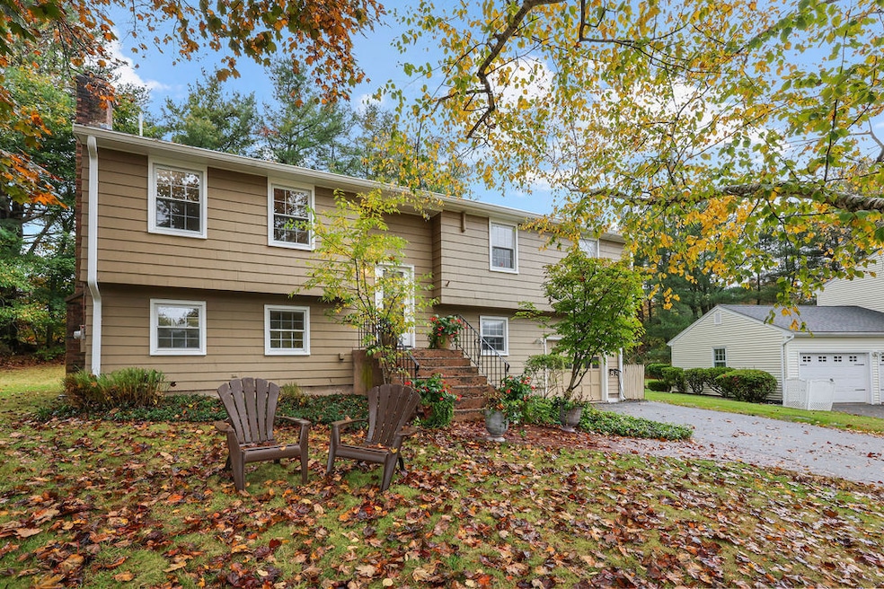
This single-family home awaits you. Conveniently located on a cul de sac near the university. Home includes three bedrooms and 1 1/2 bathrooms with a finished basement. One of the bedrooms is currently used as an office but can be easily used as a bedroom. The basement boasts an additional living space with fireplace and half bath with a washer and dryer for ease of use. Off of the kitchen you will find a beautiful deck to enjoy sitting outside on those fall nights or relaxing in the sun in the summer. Off of the attached one car garage you will find two EV charging stations to charge your electric vehicles. Home is equipped with solar panels to save on your electricity bill. Property can be rented furnished or unfurnished. Owners are open to pets with a pet deposit. Inquire with any pet questions. This one won't last long. Move in before Christmas.
Last Agent to Rent the Property
Sterling REALTORS Brokerage Phone: (860) 343-3820 License #RES.0786221 Listed on: 11/10/2025
| Date | Buyer | Sale Price | Title Company |
|---|---|---|---|
| Landers Richard T | $220,000 | -- | |
| Hassett Michael P | $126,000 | -- | |
| Hertler William C | $157,000 | -- |
| Date | Status | Borrower | Loan Amount |
|---|---|---|---|
| Open | Hertler William C | $264,000 | |
| Closed | Hertler William C | $184,000 | |
| Closed | Hertler William C | $176,000 |
| Date | Event | Price | List to Sale | Price per Sq Ft |
|---|---|---|---|---|
| 12/20/2025 12/20/25 | Rented | $2,700 | 0.0% | -- |
| 11/10/2025 11/10/25 | For Rent | $2,700 | -- | -- |
| Year | Tax Paid | Tax Assessment Tax Assessment Total Assessment is a certain percentage of the fair market value that is determined by local assessors to be the total taxable value of land and additions on the property. | Land | Improvement |
|---|---|---|---|---|
| 2025 | $6,984 | $179,530 | $57,940 | $121,590 |
| 2024 | $6,607 | $179,530 | $57,940 | $121,590 |
| 2023 | $6,302 | $179,530 | $57,940 | $121,590 |
| 2022 | $5,968 | $135,630 | $42,920 | $92,710 |
| 2021 | $5,968 | $135,630 | $42,920 | $92,710 |
| 2020 | $5,995 | $135,630 | $42,920 | $92,710 |
| 2019 | $6,022 | $135,630 | $42,920 | $92,710 |
| 2018 | $5,927 | $135,630 | $42,920 | $92,710 |
| 2017 | $5,754 | $135,700 | $49,870 | $85,830 |
| 2016 | $5,475 | $132,880 | $49,870 | $83,010 |
| 2015 | $5,262 | $132,880 | $49,870 | $83,010 |
| 2014 | $5,315 | $132,880 | $49,870 | $83,010 |
K
Landlord's Agent in 2025
Kienda Sims
Sterling REALTORS
(860) 805-5729
9 Total Sales

Tenant's Agent in 2025
Susan Sinnott
William Raveis Real Estate
(860) 301-4044
21 Total Sales
Source: SmartMLS
MLS Number: 24139379
APN: MTWN-000030-000000-000077
Disclaimer: Certain information contained herein is derived from information provided by parties other than Homes.com. All information provided is deemed reliable, but is not guaranteed to be accurate and should be independently verified.
![]() IDX information is provided exclusively for personal, non-commercial use, and may not be used for any purpose other than to identify prospective properties consumers may be interested in purchasing. Information is deemed reliable but not guaranteed.
IDX information is provided exclusively for personal, non-commercial use, and may not be used for any purpose other than to identify prospective properties consumers may be interested in purchasing. Information is deemed reliable but not guaranteed.
Ask me questions while you tour the home.